
This map is an amazing survival. I thought it would be helpful if I explained its value. Its index number is MAN 1613 SAX. I have seen the map posted on social media recently, but without provenance. I am delighted in the considerable interest in Bradford history that has emerged on-line over the last few years, but it is always helpful to readers if posters give references to the origin of any books, maps or photographs employed. I think it is also courteous to acknowledge any help provided by the Local Studies Library or Bradford Archives. They have certainly assisted me on more occasions than I can easily count, and it is hard to imagine undertaking serious local history research without their support.
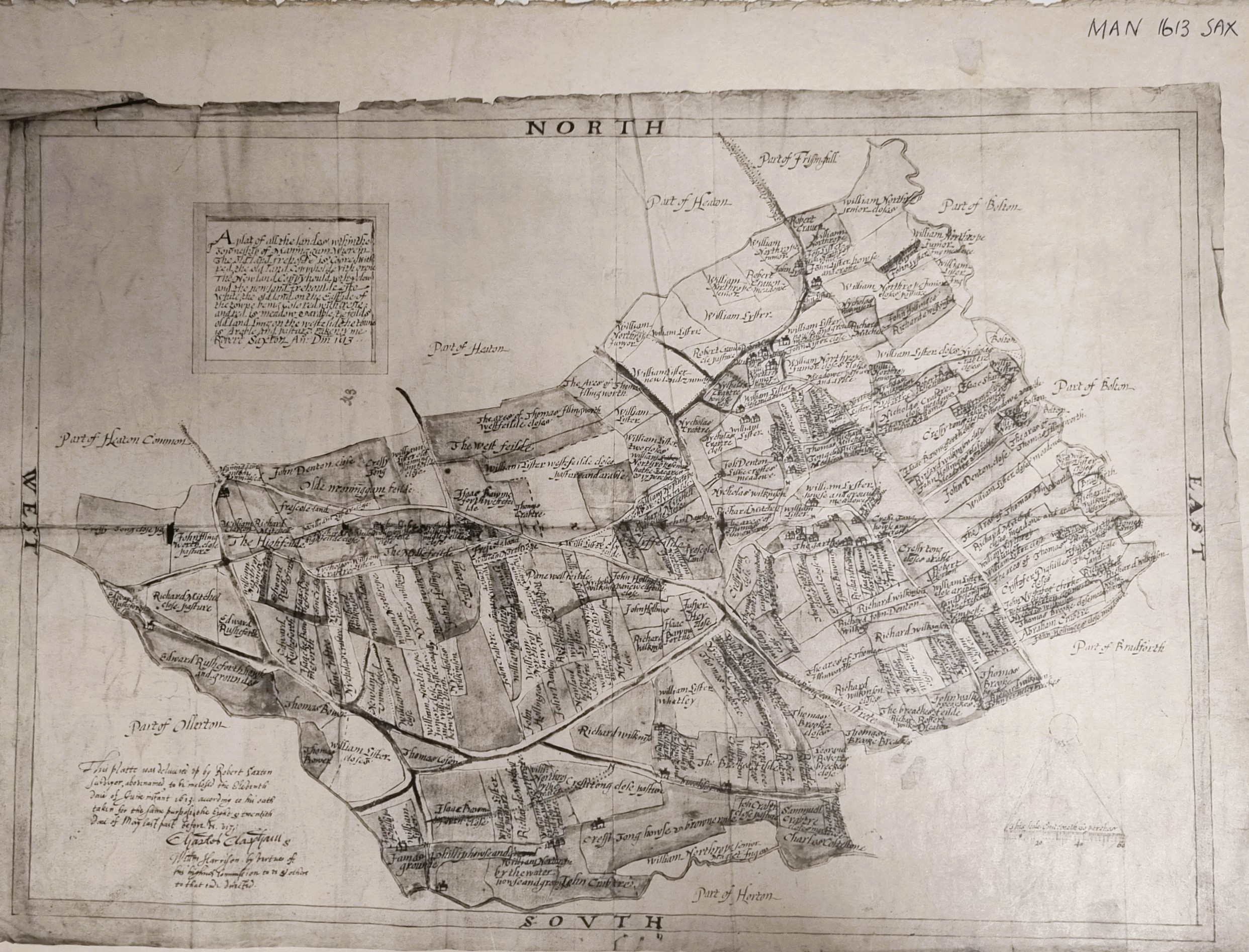
The map is essentially a survey produced by Robert Saxton, son of the more famous Christopher Saxton, in 1613. An investigation of the Local Studies Library map index with members of staff revealed that the LSL has two versions, a coloured facsimile, but also a monochrome photograph or photocopy. The West Yorkshire Archives (Bradford) have confirmed that the original map is in the National Archives at Kew. I have seen it reproduced occasionally. One example of this use is in the excellent English Heritage booklet on Manningham: Character and Diversity in a Bradford Suburb by Simon Taylor and Kathryn Gibson (2010).
In the LSL there are several other detailed maps of Manningham, including two of 1811, which makes the history of this suburb relatively easy to track. Returning to the Saxton copies, both versions are kept in the basement stores. The staff would happily retrieve them if you wanted to study them yourselves, but please be patient if the library is busy. The question of the accuracy of such an early map naturally arises, and here again we are very fortunate. David I Bower has published a most detailed study of this topic entitled: The accuracy of Robert Saxton’s survey and map of Manningham, dated 1613. This recent and well-referenced work is easily available on-line. The Saxton map is generally reliable but does have some inconsistencies which the author makes clear.
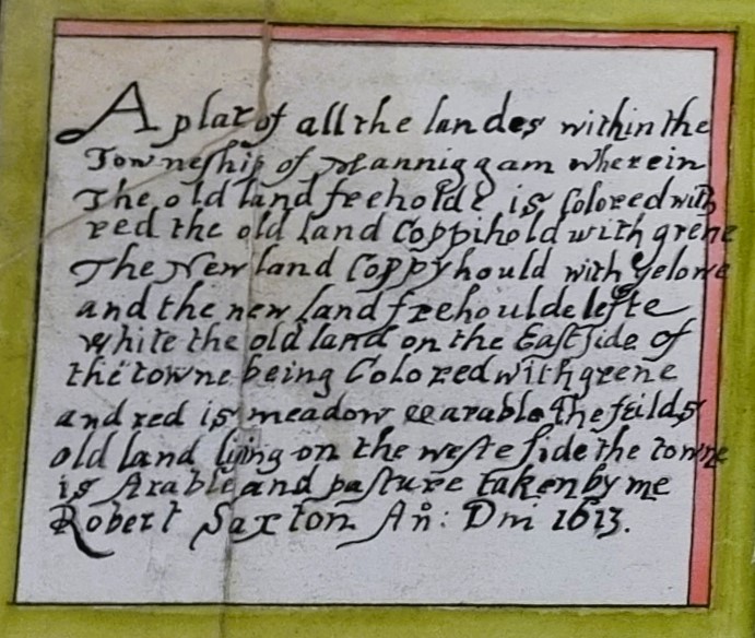
I often complain that old maps are undated, and that their purpose remains unclear. The last figure demonstrates that this is not the case here. The true value of the Saxton map to the local historian emerges when it is studied in detail.

The road running diagonally across the image follows the approximate line of the future Manningham Lane and Keighley Road. The red tinted V-shaped area is the approximate position of the future Lister Park, and it ends at the Carr Syke, a beck which in this location forms the boundary between Manningham and Heaton. To the left of this V-shape there is an untinted area annotated as ‘new land enclosed’. I have often puzzled over the date of land enclosures in Heaton Royds and Northcliffe Park, Shipley, which were clearly much earlier than the Enclosure Acts of 1780-1820. Here there is piece of reliable evidence reflecting on the early alteration of the status of common land.
I have long been interested in the history of Lister Park in the years before it was acquired by Bradford Council and the subsequent building of Cartwright Hall. The approximate position of Cartwright Hall, and its predecessor Manningam Hall, is occupied by the house and meadow of ‘William Lyster’. According to Bradford historian John James this William Lister died in the English Civil War. Surprisingly perhaps his remote descendants were Ellis and Samuel Cunliffe Lister still living in the area by the nineteenth century. Manningham village itself is described as ‘the garthe’.

What a fantastic map. Thanks so much for sharing and for the information on the articles about it and Manningham. LSL is always so helpful and goes the extra mile to find information if it can. Long may we have LSL in Bradford and elesewhere.
LikeLike