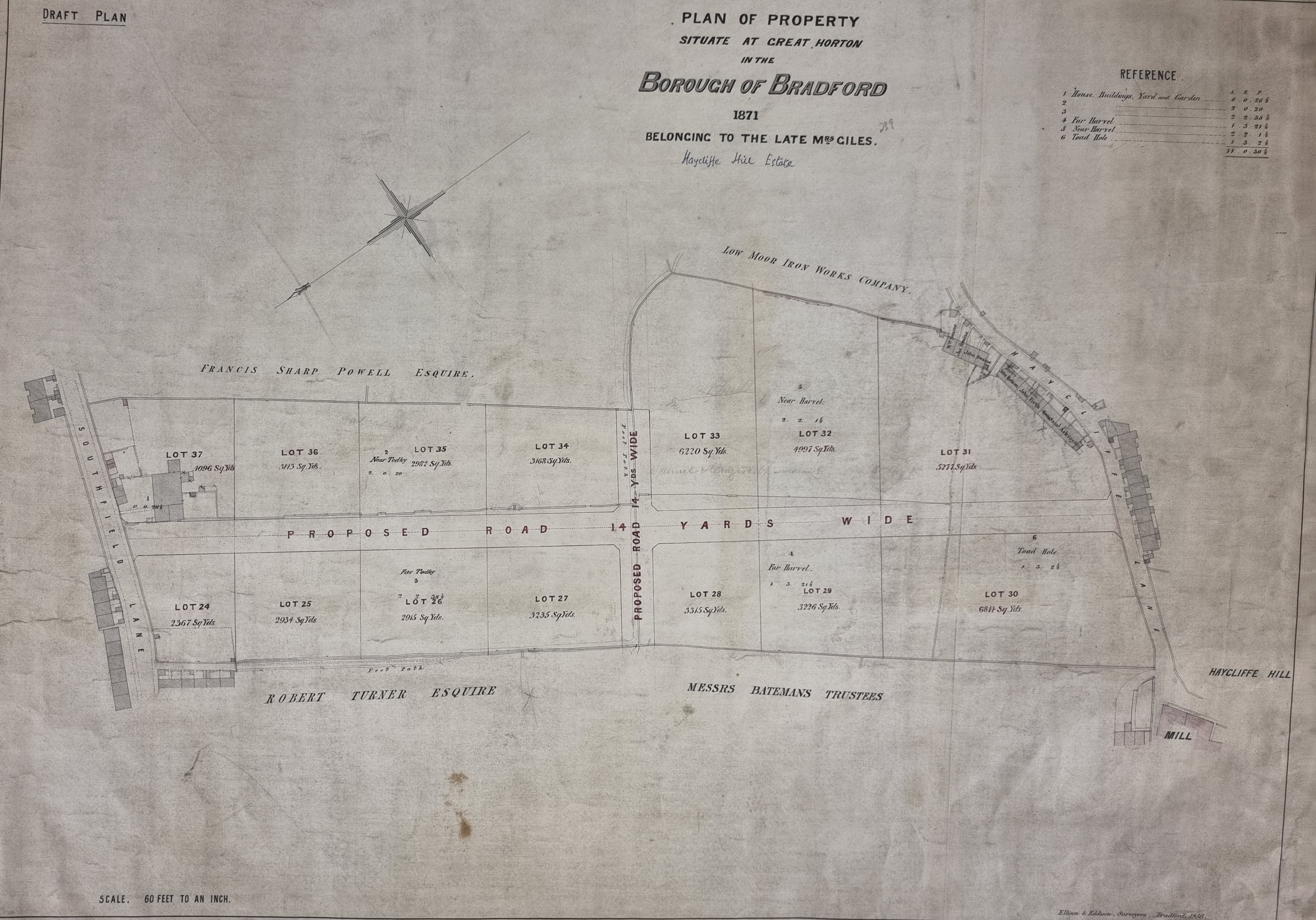
I have found a second plan showing the Haycliffe Hill area of Horton, drawn a year after the last one I included in 1871. Rotating it 90 degrees clockwise gives a better fit to the orientation of a modern OS map. Evidently a large Bradford landowner ‘Mrs Giles’ has died and they are selling off her estate.
Mrs Giles was Ann Giles who possessed much property in Great Horton including Haycliffe Hill and Southfield Lane with the fields in between. The means by which she acquired her estate was quite complicated. Hannah Gilpin Sharp (1743-1823) of Horton Hall bequeathed her mansion, with all her land in Bradford, to her nephew, Captain Thomas Gilpin and in ‘default of issue’ to her niece Ann Kitchen. Captain Gilpin died at Madeira in the year 1826 without ever having been married. So, Ann Kitchen came into the property. In 1828 she married a clerk in Somerset House, Edmund Giles. Their son, another Edmund, was baptised the following year. Ann’s husband died in 1832 leaving his infant son as heir to the Horton estates. At the age of 25 this son Edmund went to Australia, being enamoured of sea life, but only lived three days after landing in the colony. So all the property was Ann’s again. In 1839 an Act had been passed for disposing of the Giles estate at Horton, owing to the great increase of buildings in the immediate vicinity. Land belonging to ‘Mrs Giles’ are common on maps of Bradford and Horton. Her daughter by her first marriage, Ann Haines, was ultimately to inherit her estate. Ann Giles died in 1855 so that trustees must have managed her property for 25 years.
A number of landowners are mentioned in addition. The Low Moor Iron Company owned a good deal of property. Their interest was normally the ironstone and coking coal under it. Francis Sharp Powell (1827-1911) became an MP in 1857. In 1892, he was created a Baronet and consequently became ‘Sir Francis’. He must have been a large landowner, and his name frequently appears on our maps.
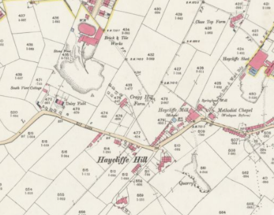
The second figure is from the 25” 1890 OS map of the area. If you can identify Haycliffe Mill on both maps you can see that immediately west of the first mapped area was a most important Horton brickworks and quarry operated by the Bradford Brick & Tile Co. Ltd. This company was founded in the late 19th century, and operated several Bradford brick-kilns in the 1880s. This works were still open in 1927 but closed by the time of the 1938 map, with the company moving operations to its Leeds Road kilns. In 1904 the BB&T Co (in the person of their energetic secretary James Priestley, Daisy Field, Haycliffe Lane) generously gave Bradford Corporation tens of thousands of stones from their Great Horton works to make the bridges and retaining walls of Brownroyd Hill Road (St Enoch’s Road) then being constructed to Wibsey (Parker 1904: 183). This gift suggests that they were quarrying stone, or that stones were a unwanted biproduct of a fireclay or mudstone quarry.
The site later occupied by these works are in fact mentioned by Cudworth (1876): ‘at Close Top Farm, Southfield Lane, John Smith, grandfather of the present occupier, employed many hand wool-combers, and made tops for the trade around Great Horton. Cragg Farm belonged in 1800 to Mr. Gorton, having been previously a portion of the Brooksbank estate, and was occupied by Samuel White, who not only followed the occupation of farming, but was the shoemaker for the district. The land upon which New Harrogate is built formerly belonged to this farm. Benjamin Knight, the cotton spinner, bought the property of Mr. Gorton, and on his bankruptcy the late Mr. George Hadfield, once a candidate for the Parliamentary representation of Bradford, took possession of Cragg Farm, it was said, for the legal expenses incurred by Knight. A portion of the land has turned out valuable, the Bradford Brick and Tile Company having opened it out for brickworks.‘

Aligning the initial image (the Plan) with the 25-inch OS map from the 1930s, shows the following:
(a) The horizontal ‘Proposed Road’ was not built on that alignment. However,
Haycliffe Road was built parallel to it but slightly lower down the ‘Plan’ diagram.
(b) The vertical ‘Proposed Road’ is Clover Street.
(c) The old footpaths remained.
(d) The Salvation Army Citadel on Southfield Lane was built in the top left corner of ‘Lot 37’.
(e) The gap between the houses on Southfield Lane on the very left of the ‘plan’ is where
Hudson Avenue curved off, making for Cross Lane.
LikeLike