
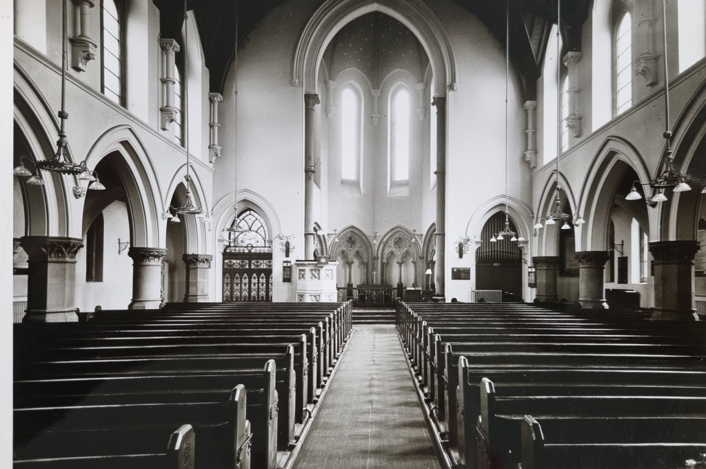
Many of these places of worship I have described individually in the past, but I thought it might be helpful to local historians if I gathered my conclusions together in one place. The C of E is represented by St John’s Church which was opened in 1839 at the bottom of Manchester Road.

I know that any early success for the new church was vitiated by a quarrel between the incumbent and the Vicar of Bradford (and whaling captain) Dr Scoresby. The building was demolished after about 30 years.
The oldest non-conformist chapel is the building that gave its name to Chapel Street (Toad Lane) in the old town centre. I have heard this chapel described as Presbyterian, Independent and finally Unitarian. I can track a Unitarian Chapel on this site as late as the 1934 25” OS map, but I believe it was finally demolished in the late 1960s.

The Local Studies Library has some photographs which are part of the Wade Hustwick collection; they are labelled ‘Chapel Lane chapel’ and show the interior. One useful pointer is that in one there is a visible memorial plaque to Samuel Copeland Kell (d.1869) of North Lodge Manningham (a stuff merchant of Kell & Co). He was buried at Undercliffe but was definitely the son of a Unitarian minister (Robert Kell), according to contemporary press reports. This would suggest that the labelling of the photos is correct.

Horton Lane Independent Chapel was over the border in Horton close to Rands Mill. I know that it became a popular and hugely influential Congregational Church. It was constructed in the 1780s and I have heard that those involved were part of the Chapel Lane Chapel congregation who could not tolerate Unitarianism.
The chapel was famously attended by the first Bradford mayor Robert Milligan, and Titus Salt. Scruton’s Pen & Pencil Sketches of Old Bradford contains an image, but the building itself was also demolished in the late 1960s I believe. The next image originally appeared in the Bradford T&A.
The last two images would suggest that Horton Lane Chapel was radically rebuilt at some stage.
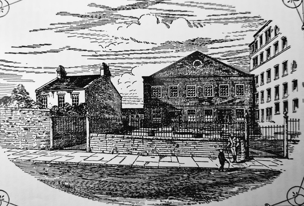
The main body of the Methodist Church built an Octagon Chapel in Horton Lane which opened in 1776; the picture is taken from Scruton’s book, but the building lasted little longer than St John’s Church,

After that the Methodists moved to Eastbrook Chapel. The original Eastbrook Hall or Chapel was built in 1825 on land purchased from banker Charles Harris. This chapel is shown well on a mid-century map which locates it close to the Parish Church and the first Mechanics Institute. The chapel this was replaced in 1903 by the more familiar Edwardian building.
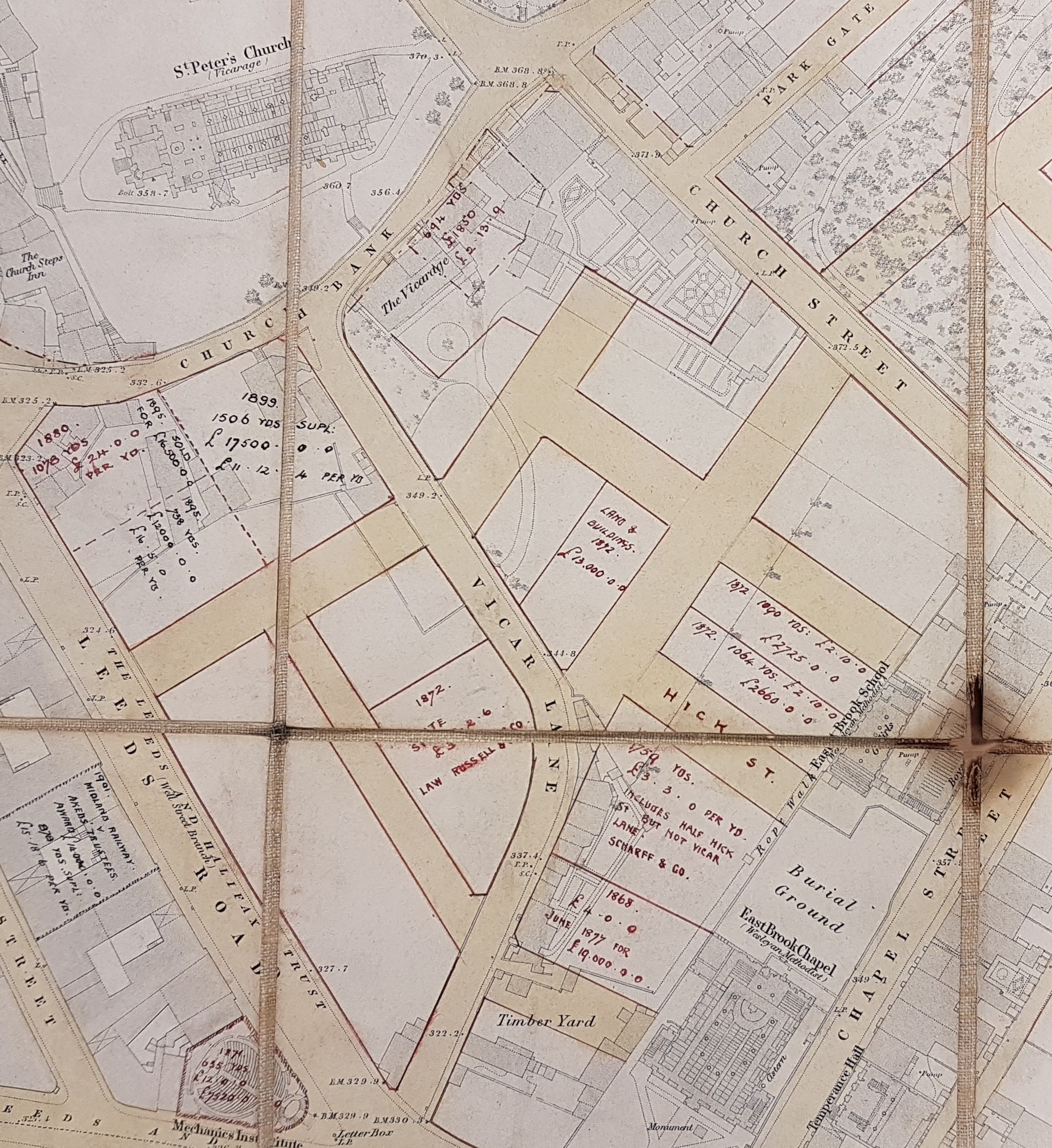
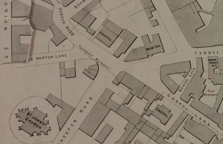
I believe that we have two other city centre Methodist chapels to locate. Organisational, and perhaps theological, differences within the church meant that there were also Primitive Methodists. They built a chapel at the end of Manchester Road (1824). A second group, called the ‘New Connexion Methodists’, were to build the Ebenezer Chapel at the bottom of Horton Lane in 1839, on land sold by Rev. Godfrey Wright. They are both on this detail of this Milnes & France 1876 town centre plan.
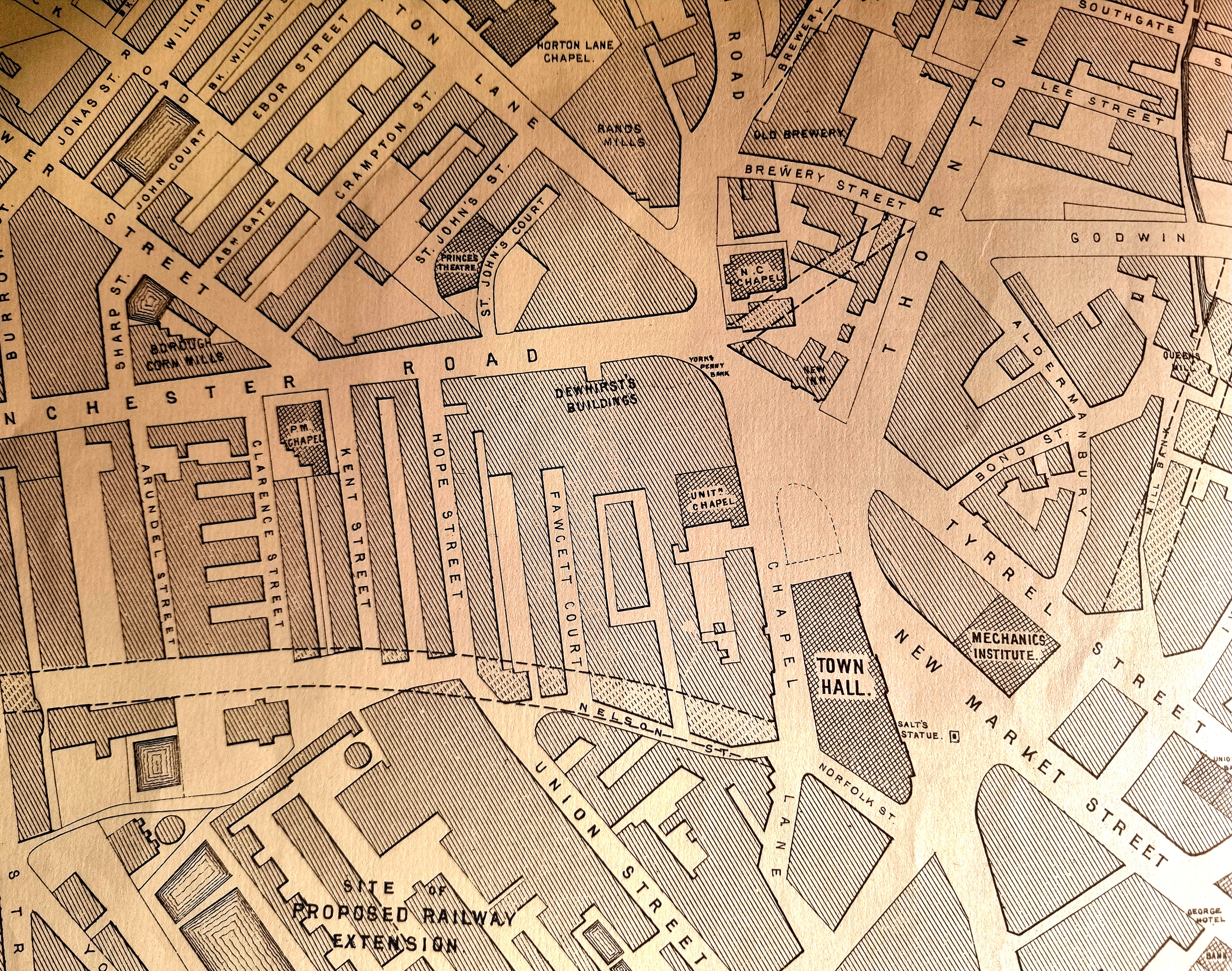
If you travel upwards from the new Town Hall, you soon pass the Unitarian Chapel and above the New Inn is the NC Chapel. NC must = New Connection. Turning left along Manchester Road we pass the site of the now demolished St John’s Church and come to the PM Chapel on Kent Street. PM must = Primitive Methodist.
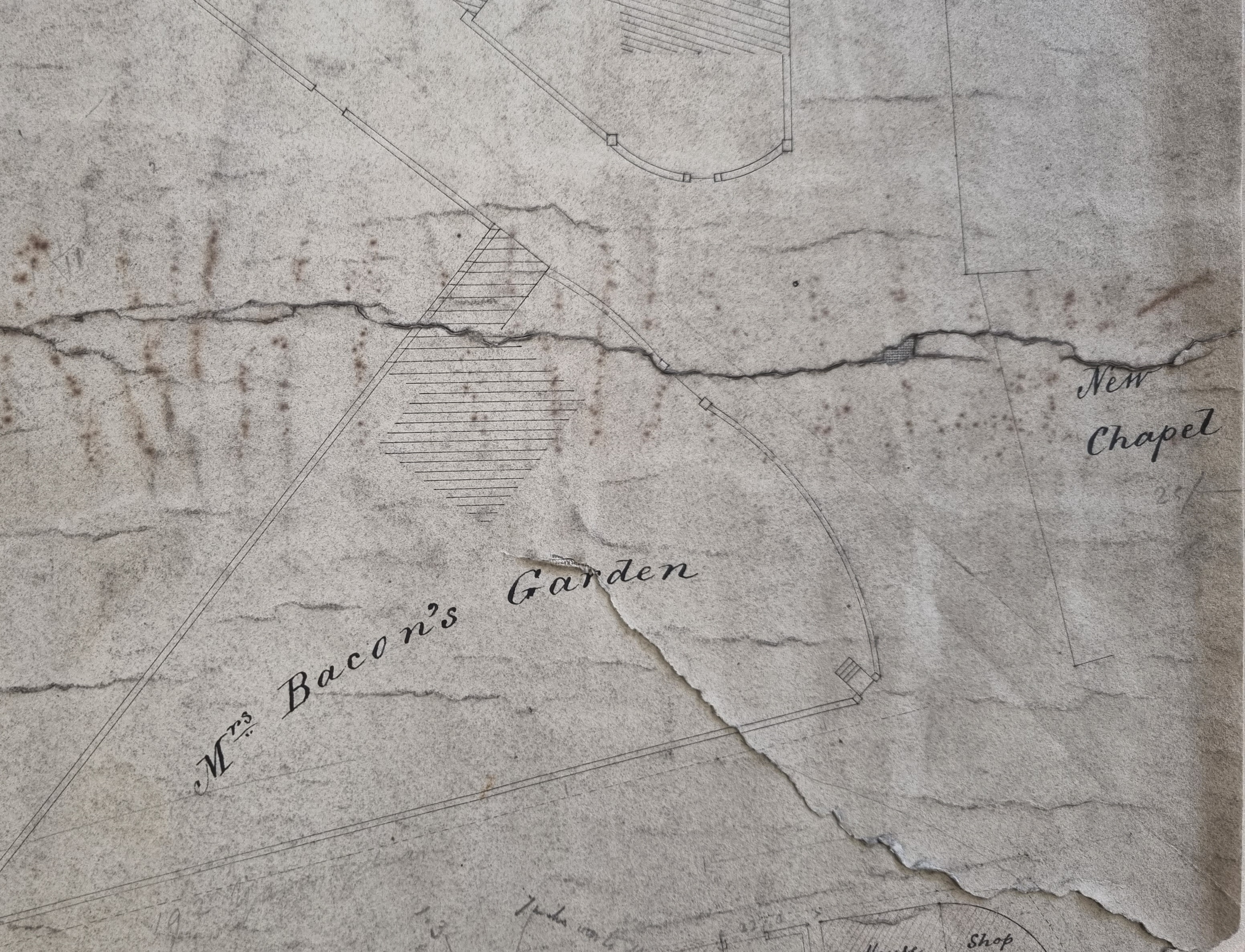
Finally, there is this 1830s map that I have used before. It shows a ‘New Chapel’ building opposite Mrs Bacon’s property. Rather inconveniently, since the church embraced temperance, it was then next to a wine and spirit warehouse though this is not drawn, but it must be the New Connection chapel.

The next religious group whose nineteenth century location I can identify is Society of Friends (Quakers). In 1832 a Quaker School was built near the Methodists in Chapel Street on land given by banker Charles Harris. This was opposite the first Temperance Hall built in 1837 (again on land given by Harris). A piece of contemporary literature from the Local Studies Library suggests that the Quakers were as opposed to the ‘demon drink’ as Methodists and Salvationists. The Quaker Meeting House and burial ground was, at this period, in Wakefield Road. The Local Studies Library has this map that clearly identifies its location. Scruton relates that this Goodman’s End Meeting House had been rebuilt and extended on the same site on several occasions. Finally, it was consumed in the expansion of the Yorkshire & Lancashire Railway. The land adjacent was owned by the Wesleyan Association and before long another chapel was built there.

The main group of non-conformists I have not yet mentioned so far are the Baptists. I understand that the Baptists had a presence in Bradford from the mid-eighteenth century although they may have been active in Heaton at an even earlier date. John James in his History of Bradford reports that there were Particular Baptists and General Baptists. Seemingly General Baptists did not then hold ‘Calvinistic views’. Westgate chapel was founded in 1753-55, and described by William Cudworth as the Top o’ t’ Town chapel. it seems to have belonged to the General Baptists. William Scruton adds the additional detail that they initially used the Mill Goit at the bottom of Silsbridge Lane for baptisms. The Local Studies Library reserve collection of maps has this detailed descriptive plan of the Westgate Chapel, which, together with a Sunday school and burial ground, was once situated between Westgate and Long Lands Street. The Sunday or Sabbath School was clearly a flourishing institution. The Bradford Observer reported in June 1840 that it had 910 scholars, and had to be enlarged. The boys and girls had separate yards, and separate privies! The minister in the early nineteenth century was the Rev. William Steadman D.D who died in 1837 after a pastorate of more than thirty years. A memoir of his life by his son Thomas was published in 1838 and reviewed in the Bradford Observer. I believe the chapel was demolished in the early twentieth century and that the Westgate Baptist Chapel, Carlisle Road, Manningham was built, or rather rebuilt, around 1900 to replace it.
On Bridge Street near St George’s Hall was the Zion or Sion Chapel. Scruton says this was Baptist, and an early minister was Benjamin Godwin. By 1912 a Sion Chapel was at Harris Street / Peckover Street in Little Germany. Higher up Westgate was the Zoar Chapel (Strict Baptists), and nearby was Hallfield Road Chapel, Manningham an offshoot of Sion Chapel.

This detail from a map in the Local Studies Library closely resembles the 1832 Bradford Plan and shows land near the present city centre divided up for sale or auction. Internal evidence suggests that it continued in use for 15 years or so with additions and annotations. Since I am presently exploring central non-conformist places of worship you will understand that I was most intrigued by the Ranters (Providence) Chapel. I cannot find out a great deal about the Ranters, who were seemingly named for their passionate style of worship, except that they broke away from the Wesleyan Methodists around 1810. This portion of the map shows Bowling Lane, which before long acquired the name Manchester Road. If you follow the Bowling Lane you will see Croft Street, Croft House (home of the famous solicitor Samuel Hailstone), Miss Hartley’s land, Samuel Hailstone’s office which may well have generated this map, Clarence Street, Providence Chapel, and King Street. Above this, surprisingly, is a Malt Kiln. In the original map I can follow the Bowling Lane to its end: a property block, Hope Street, Odd Fellows Arms, then 3380 sq yards sold in 1848 for £3150 to Richard Waddington, then a stable, blacksmith’s, small house and shop.
Opposite, at the corner with Horton Lane, is ‘Mrs Bacon’s garden’ again. I believe that this was the widow Mary Bacon (1770-1853) who lived at Spring House, Little Horton. Thanks to William Scruton we do know a little about her. Writing in the late nineteenth century he said that her house would be remembered by many, but even if that were not the case, the good deeds of the occupant would be recalled ‘for she spent her life in acts of kindness’. Across the road from Mrs Bacon was the New Connection Methodist Chapel, but just before you reached her property there was a huge empty piece of land belonging to Rev. Godfrey Wright, Bradford’s biggest land-owner in the early 19th century. Into much of this space was built St John’s Anglican Church, which I have already mentioned (1839). By this time Mr Waddington had erected a convenient city centre foundry opposite: sacred and profane in mid-19th century Bradford.
Where are we in today’s city? Croft Street remains and Hope Street must have run across Jacobs Well (now a car park since the demolition of the office building). A parallel road to Hope Street placed just off the bottom of our map is Kent Street. Remarkably this road has survived the vicissitudes of the 19th and 20th centuries until the present day, with the Jacobs Well Pub (1830) being its last surviving building. The Providence Chapel seems to have ended in car-park which would have certainly given the congregation something to rant about.
Have I omitted anybody? The answer is several groups. To fully understand the changes of belief, and changes of place over time, would need very serious research indeed. I shall illustrate this with some contemporary literature from Bradford Local Studies Library.

The original Christ Church was CofE and built in 1815. It, and its replacement, are long gone. In south Bradford, the Wesleyans constructed a chapel near the Quakers on Wakefield Road. This survived until the 20th century. In Manchester Road (Kent Street) by 1912 was the Primitive Methodist Central Hall. In Westgate, opposite the Infirmary on Holmes Street is a WM Chapel and there are others off Tumbling Hill Street and Carlisle Street, Manningham. I assume WM = Wesleyan Methodist
The Quakers themselves moved to Fountain Street in 1877, where the broken portico of their building stands to this day.
In streets around St Luke’s Hospital there was a Moravian Church, All Saints Church (CofE), a Wesleyan Reform Chapel and ‘Centenary Chapel’. On your way back into Bradford you would pass Trinity Chapel and school (Baptist).
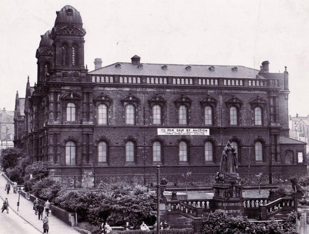
In Manor Row was the famous Salem Chapel which served the Congregationalists under its famous minister Rev. JC Miall. ‘Salem’ is a shortened form of Jerusalem and was a popular name for non-Conformist places of worship. This classical revival building was constructed in 1835-6 using ashlar sandstone. It was one of the earliest designs of the Lockwood & Mawson architectural partnership who later moved on to design St George’s Hall and the Town Hall. A new chapel was opened in Oak Lane in 1888 after which the Manor Row building was reused as school board offices, and a school clinic for many years. It still exists as Kenburgh House.
Near Copy Quarry are the Westgate Baptists who were mentioned previously, but in Simes Street is a ‘Scotch Kirk’ which survived into the 1912 map. There was another chapel in Infirmary Street which I believe was for the Presbyterian Church of England (1849). Was this called the Bethel Chapel? There was also a Swedenborgian ‘New Church’ in Drewton Street which had previously been a school room. In Darfield Road was quite a large Methodist chapel. In Longlands, an area popular with Irish immigrants, was St Thomas’s Church, a RC School, and a RC Chapel. Towards the end of my period the first Bradford Jewish Synagogue was constructed. There has long been a Salvation Army Citadel in Leeds Road: was this the first in Bradford? There was a Ryan Street Congregational Church: was this the Ryan Street in Wibsey?

As to the affiliations of the Rehoboth Chapel in Bowling Old Lane I must pass, and although I have the name ‘Mount Carmel Chapel, Little Horton Lane’ I know nothing more of it as yet. That’s enough for now from me: now over to you!

I wonder if you are able to identify Brierley Fields located along Bowling Lane, It was bought by my 5x Great Grandfather, Matthew Harrison; from Mary Stead and Martha Stead both of Tong, spinsters, daughters and coheirs of Robert Stead, late of Tong, schoolmaster, deceased in 1810?
LikeLike