3.023 BRA 1837 PLA BHM 567 B9
Material: paper Scale: unk
Size: 110 *76 cm Condition: poor
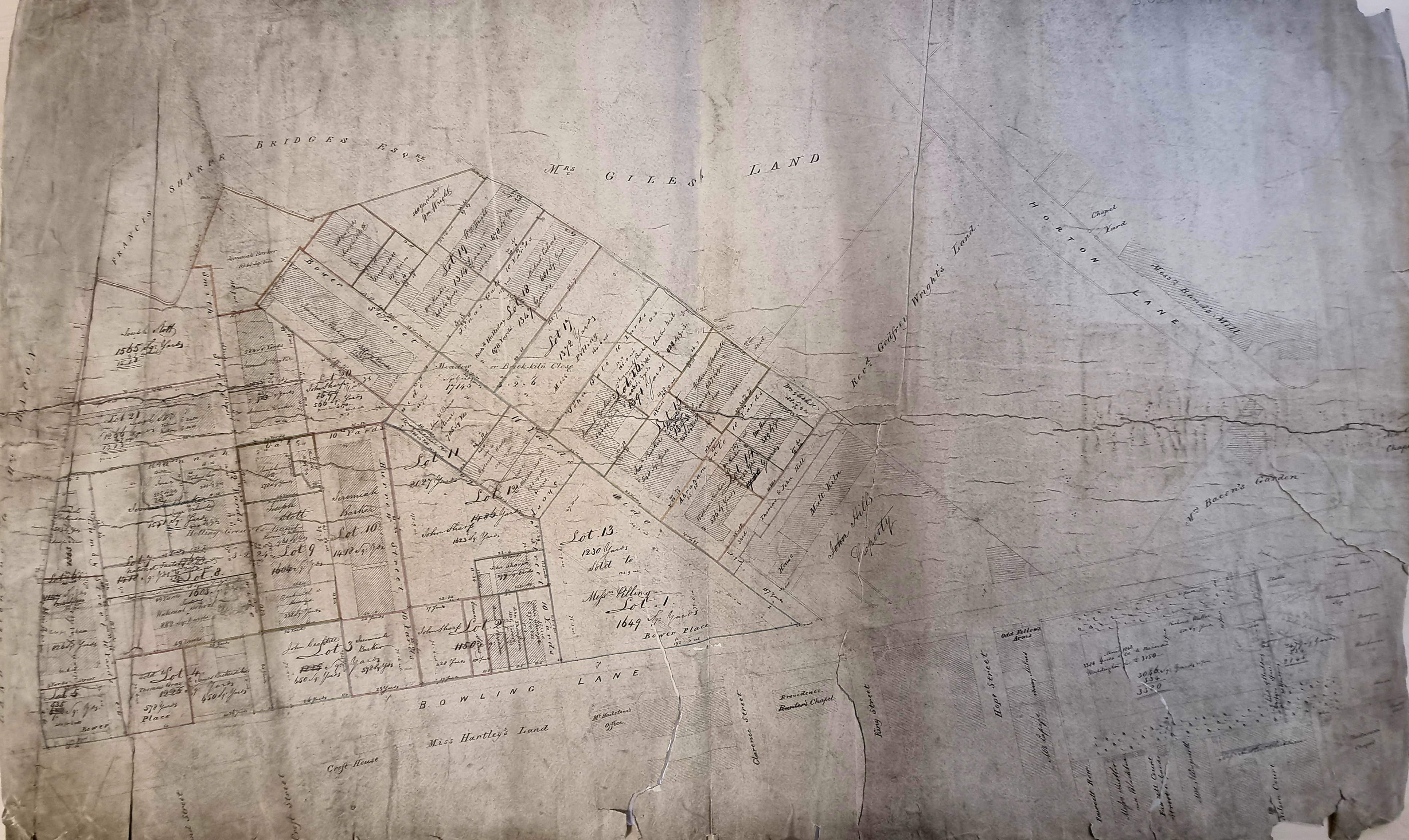
I have used this plan on several occasions before, since its careful study reveals a huge amount of Bradford history. It shows a large parcel of land around the junction between Horton Lane (now Little Horton Lane) and Bowling Lane (now Manchester Road). It is clearly a sale plan for a large estate divided into over 20 lots. It illustrates the expansion of urban Bradford at this date. Modern ‘smart’ phones usually include a camera with a wide-angle lens. This means than for the first time I can provide an image of the entire map. The plan is hand drawn with many corrections and additions in both ink and pencil. Having said that, it is not easy to read the handwriting in this format, so I shall revert to magnified details. Worse still, you may think, I shall have to pull in details from other contemporary maps to give a full view of the topography of this area.
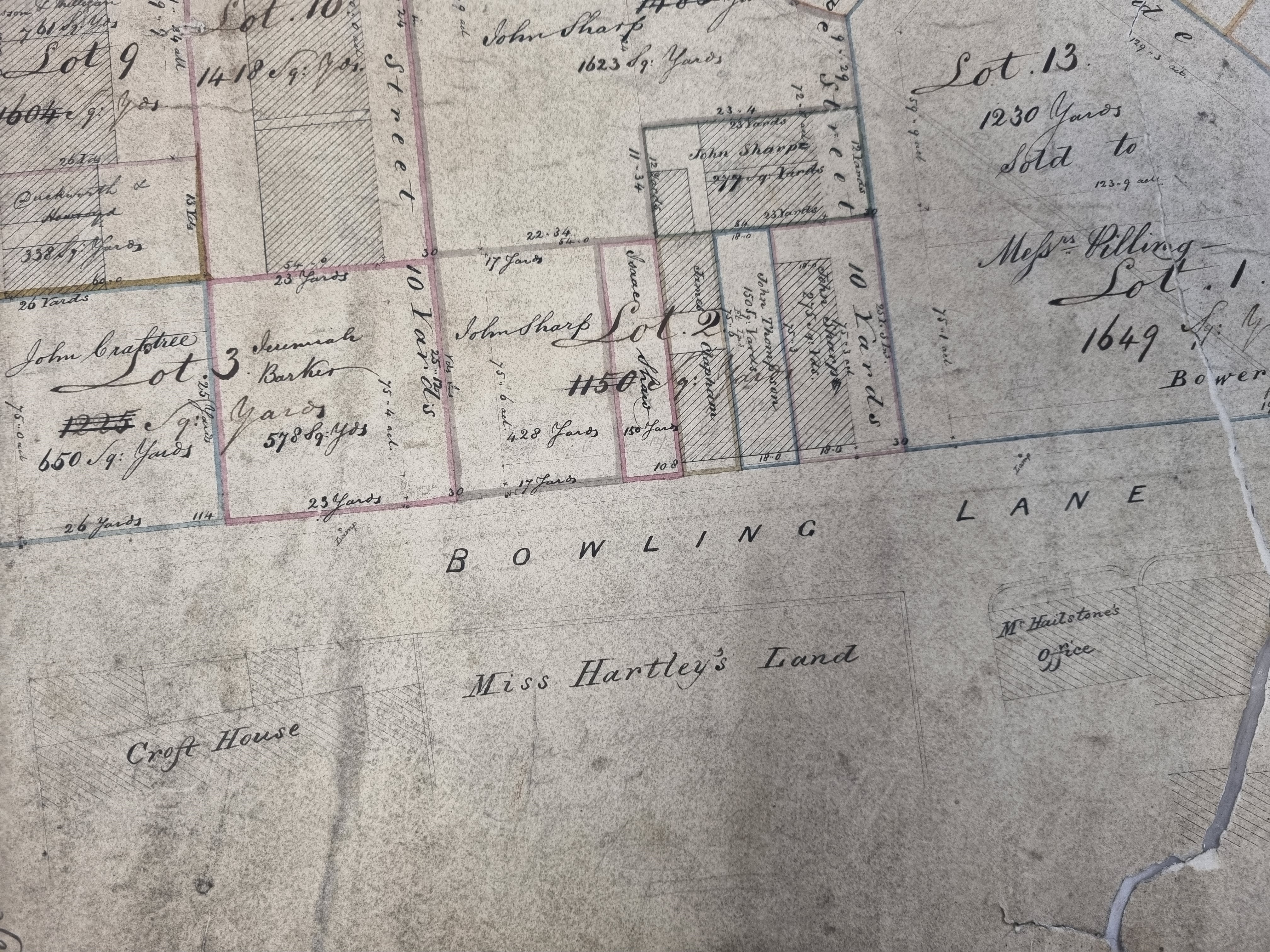
The map was presumably used in the office of the solicitor or agent responsible for the handling the sale. The man involved in the sale was almost certainly Samuel Hailstone (1768-1851) for both his house (Croft House) and place of business are included. There is a second plan, definitely dated 1837, showing that he was also offering for sale land between Croft Street & Bridge Street. This land was further south but stylistically the maps are very similar, and I am acting on the assumption these two plans are temporally linked.
Samuel Hailstone was born in Hoxton, London but his family soon moved to York. He became articled to John Hardy, a Bradford solicitor, and Hardy & Hailstone eventually became partners. I understand that Samuel and John Hardy were the moving spirits behind the 1803 Bradford Improvement Act. More than forty years before Bradford became a borough this act established commissioners with a variety of local government powers such as street cleaning, lighting, and water provision. Samuel continued to practise as a solicitor and was later in partnership with the Thomas Mason, who became a director of the Bolling Iron Company and lived at Bolling Hall. Samuel Hailstone was the classic example of a wealthy, and highly successful, professional man. His politics were Liberal and, slightly unusually for largely non-conformist Bradford, he was an Anglican. He purchased the Bolton House estate although he never resided there.

I shall start by looking at some landowners. Who was Mrs Bacon and her garden? I assume this was the widow Mary Bacon (1770-1853) who lived at Spring House, Little Horton (represented by a hatched block). Thanks to William Scruton we do know a little about her. Writing in the late nineteenth century he said that her house would be remembered by many, but even if that were not the case, the good deeds of the occupant would be recalled ‘for she spent her life in acts of kindness’. We shall come back to the ‘New Chapel’ placed opposite her property.
Rev Godfrey Wright lived at Bilham House, near Doncaster. Until he died, in 1862, he was the largest landowner in Bradford having been left an enormous legacy by Charles Swaine Booth Sharp of Horton Hall. Wright made a fortune selling off land for developments such as the Mechanics Institute, St George’s Hall, The Old Court House, and the location eventually occupied by Little Germany.
Ann Giles who possessed much property in Great Horton, including the St Luke’s Hospital site, Haycliffe Hill, and Southfield Lane with the surrounding fields. The means by which she acquired her estate was quite complicated. Hannah Gilpin Sharp (1743-1823) of Horton Hall was the wife of Charles Swain Booth Sharp who was so generous to Godfrey Wright. As his widow she bequeathed her mansion, with all her land in Bradford, to her nephew, Captain Thomas Gilpin, and in ‘default of issue’ to her niece Ann Kitchen. Captain Gilpin died at Madeira in the year 1826 without ever having been married. So, Ann Kitchen came into the property. In 1828 she married a clerk in Somerset House, as her second husband, a man called Edmund Giles. Their son, another Edmund, was baptised the following year. Ann’s husband died in 1832 leaving his infant son as heir to the Horton estates. At the age of 25 this son Edmund eventually went to Australia, being enamoured of sea life, but only lived three days after landing in the colony. In 1839 an Act had been passed for disposing of the Giles estate at Horton, owing to the great increase of buildings in the immediate vicinity. Land belonging to ‘Mrs Giles’ are common on maps of Bradford and Horton although I imagine everything was handled through trustees.
Francis Sharp Bridges (1766-1844) of Horton Old Hall was a bachelor who was, Cudworth recorded, tall, erect and portly. He lived an extremely quiet life. His only excursion was to dine weekly with his sisters at Hallfield Hall, Mannington. He was extremely wealthy but had no servants except ‘an antiquated housekeeper’ called Mrs Mallinson and a kitchen girl. He died in 1844 aged 78 years.

This area was notable for its places of worship. The Anglicans were represented by St John’s Church which was opened in 1839 at the bottom of Wakefield Road. The church, and its relationship to Mrs Bacon’s Garden, the Primitive Methodist chapel, and the Rand Mill, is shown well in this detail from another contemporary map. I know that any early success the new church was vitiated by a quarrel between the incumbent and the Vicar of Bradford (and whaling captain) Dr Scoresby. The building was demolished after about 30 years.
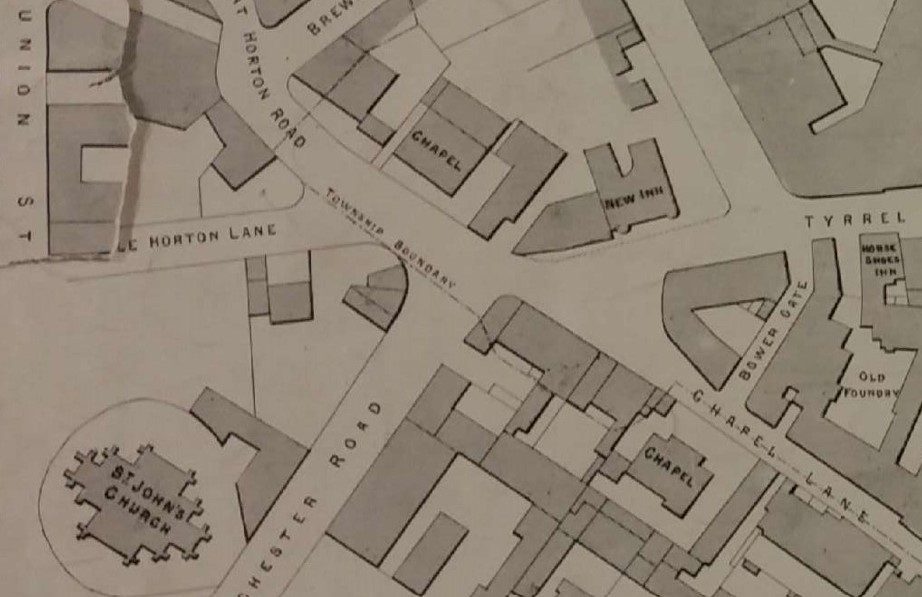
Several places of non-conformist worship appear on the map. Please let me know if I have made any errors. It is not always easy to be totally certain of the identification. Some of the chapels moved their position, and not all the denominations that met in them survived unchanged to the present day. The oldest is believed to building that gave its name to Chapel Street (Toad Lane) in the old town centre. I have heard this described as Presbyterian or Congregationalist. I have used a detail from a later map which clearly shows the placement of the chapel in relation to St John’s.
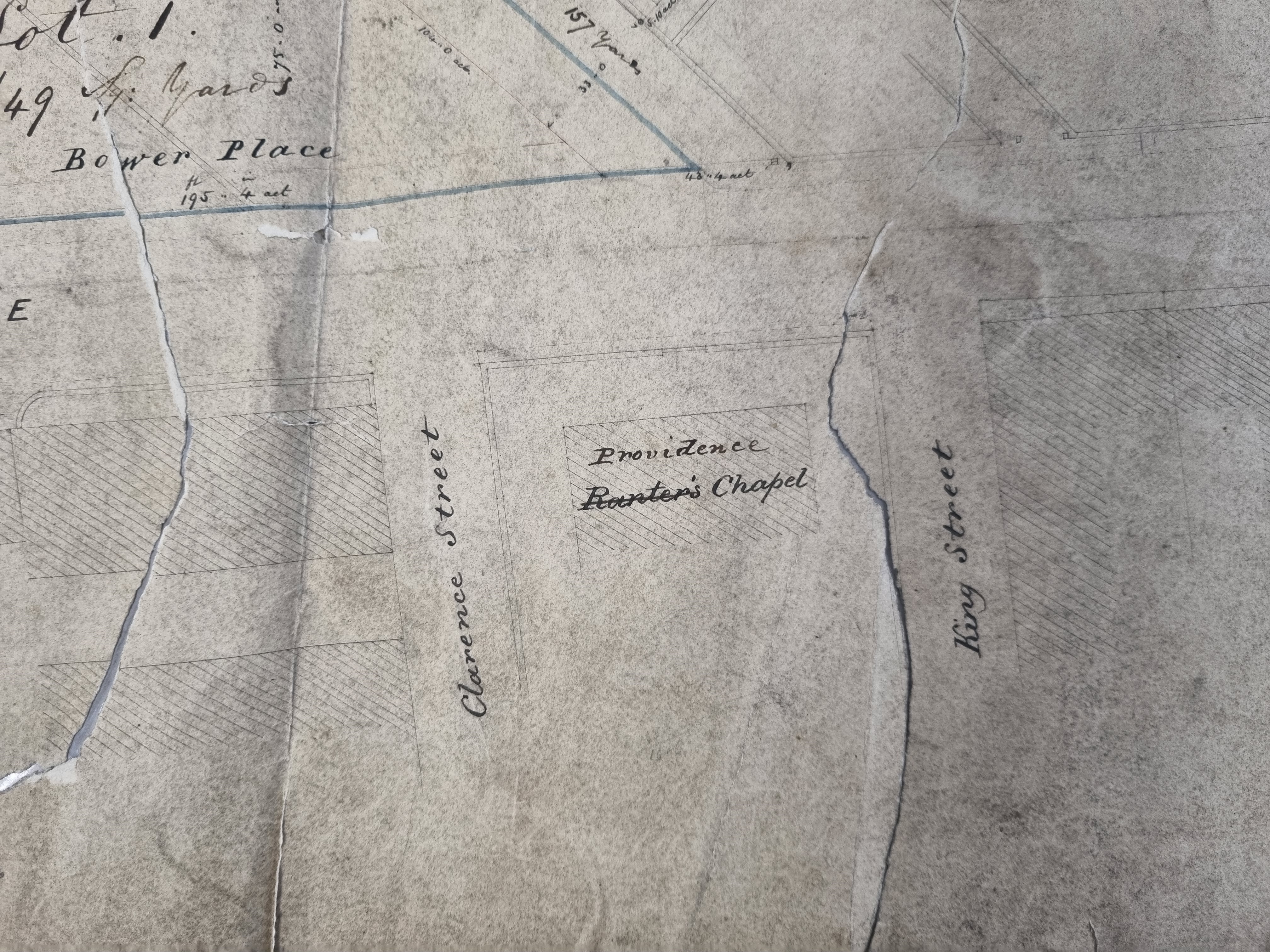
You will understand that I was most intrigued by the Ranters (Providence) Chapel. The Ranters, who were seemingly named for their passionate style of worship, broke away from the Wesleyans (Methodists) around 1810.
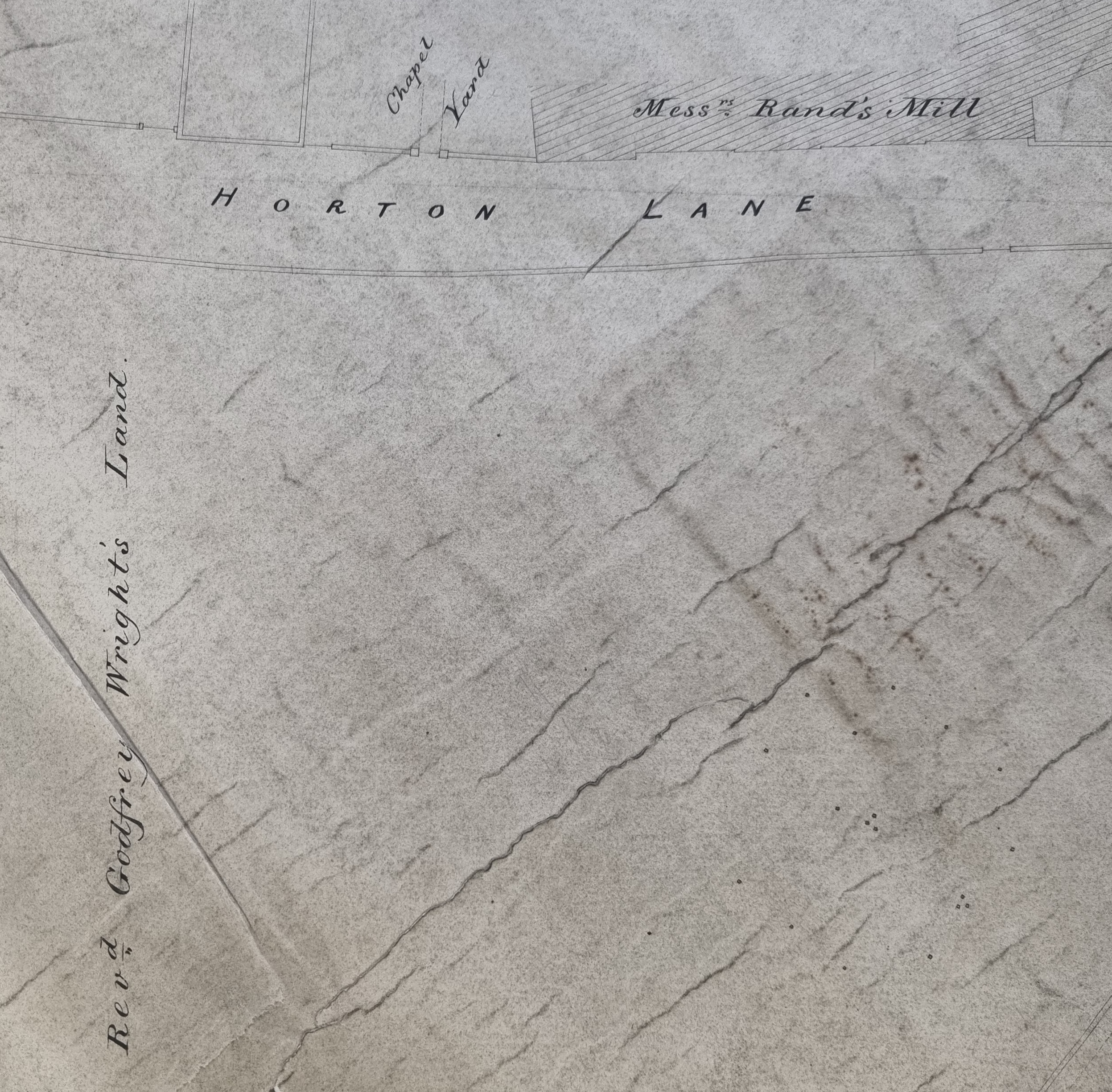


Horton Lane Independent Chapel just features on our main map, next to the Rand worsted mill. Scruton’s Pen & Pencil Pictures of Old Bradford provides an illustration, and I have a better map detail which I have included. This was a popular Congregational Church constructed in the 1780s.
The main body of the Methodist Church built an Octagon Chapel in Horton Lane which opened in 1776, but it lasted little longer than St John’s. After this the Methodists moved to Eastbrook Chapel (1825). Organisational, and perhaps theological differences meant that there were also Primitive Methodists. They built a chapel at the end of Manchester Road (1824). I believe that this is the New Chapel building opposite Mrs Bacon’s house and garden which is shown in Fig.2. ‘New Connexion Methodists’ were to build the Ebenezer Chapel at the bottom of Horton Lane in 1839, on land sold by Rev. Godfrey Wright.
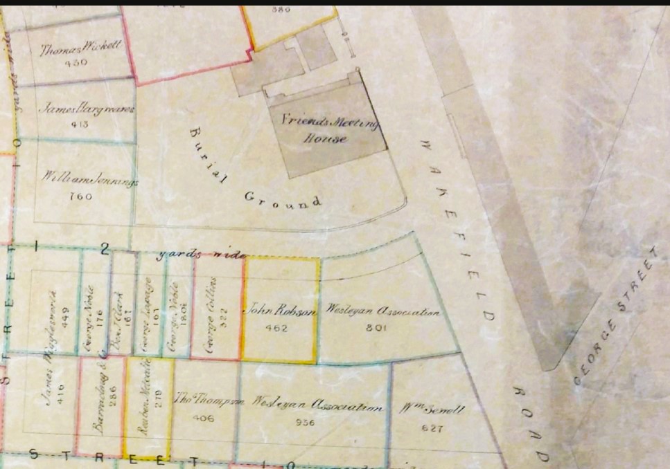
The Friends (Quaker) Meeting House and burial ground was, at this period, in Wakefield Road.
Among the industries represented on the map is Rand’s Mill. John & William Rand founded their company, an early worsted mill, in 1803. The fame of the name is largely the responsibility of John Rand jnr. (1793-1873) whose father died around the time of the plan. He was a noted businessman and philanthropist, living at Wheatley House and other locations in Manningham.

The name ‘Brick Kiln close’ is a good indication of this former industry. Before settled brick works developed bricks were hand-made and fired in clamps. Such places were located where surface clay was suitable and could easily be dug. These locations were called brick grounds. I know that in 1793 an area of Horton on Manchester Road, opposite the Primitive Methodist Church was known as ‘brick kiln field’. Later, at this site, a Mr John Buckley wanted to build a mill but was prevented by local opposition (Bradford Observer 27 October 1859).

The fact that a Malt kiln could be located so close to the town centre is a good indication of life before the development of the railways. Malt is dried germinating barley and is the starting point for the beer brewing process. I haven’t investigated the customers of this kiln but Thompson’s brewery was very close by, and at this period many public houses brewed in their own cellars.

Thank you for this fascinating article. The Chapel mentioned which was at Chapel Lane/Toad Lane was of the Unitarian denomination. Unitarian beliefs were illegal until the passing of the ‘Doctrine of the Trinity Act’ in 1813 hence the congregation may have held Unitarian beliefs but did not do so openly and were called Presbyterian after their polity. ‘Presbyterian’ congregations largely split into the Unitarian and Congregational denominations after the passing of the Trinity Act. Thanks again for a very interesting read.
LikeLike