X77 BRA c.1850 BRA
Size: 23” * 17” Material: tracing paper
Scale: 30’ to 1” Condition: good
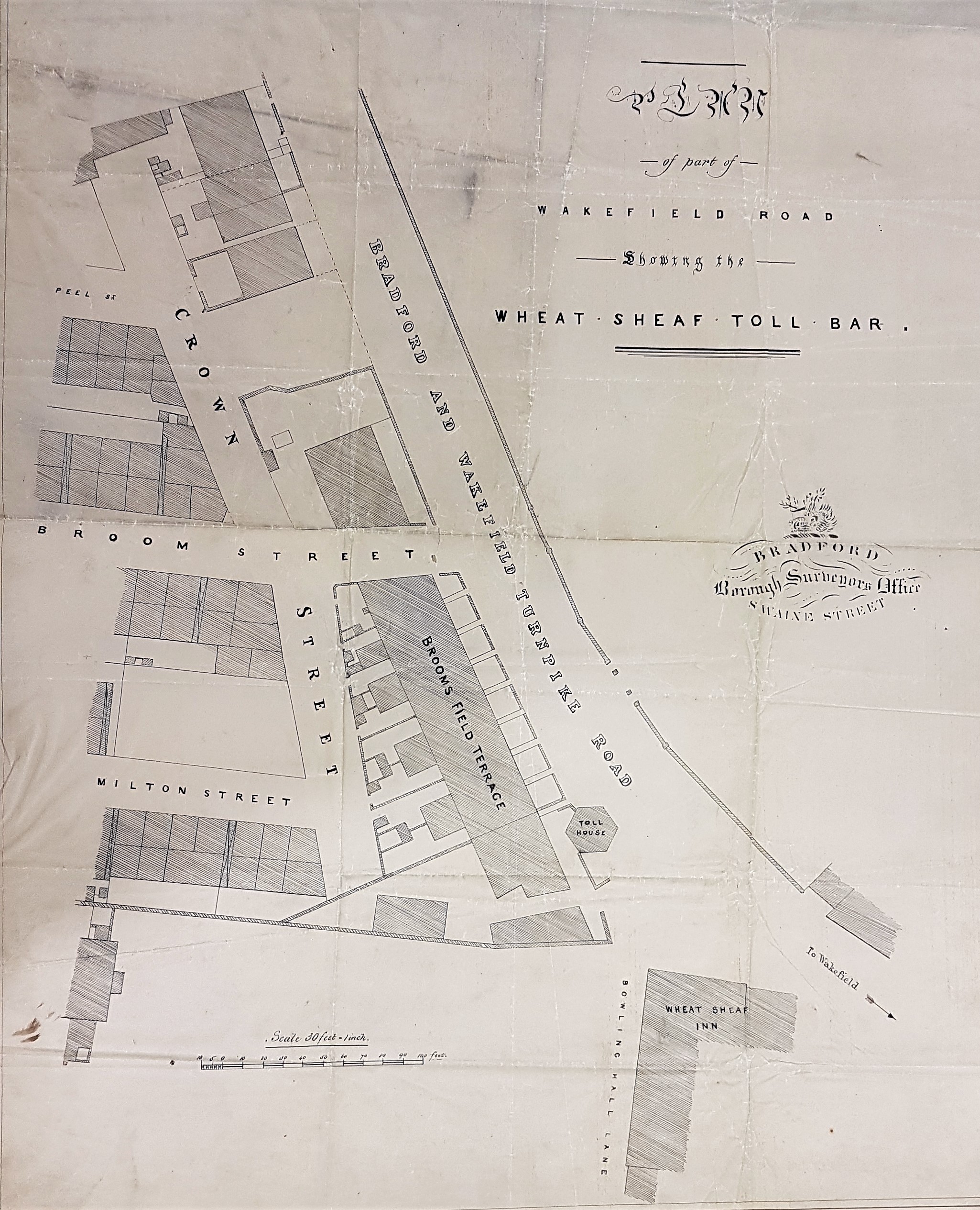
This reserve map, showing the Wheat Sheaf Toll Bar, is the product of the Bradford Borough surveyor’s office. The date can be only an approximation, but must be later than 1847 and, as you will learn, it would be extremely convenient if it were around 1850.
So, where are we? The toll bar is, reasonably enough, near the origin of the Bradford and Wakefield Turnpike Road. To the best of my knowledge this turnpike had been created at the end of King George III’s reign, say 1819-20. The Wheat Sheaf Inn might also have been constructed at that time to service road users.
The hexagonal toll collection building is just within the township of Bowling. On the other side of Wakefield Road is the historical township of Bradford. The Wheat Sheaf Bar and Inn were immediately south of Goodman’s End and east of Broomfields, at the junction of Wakefield Road and Bowling Hall Lane (now Hall Lane). By the end of the century Crown Street has become Carter Street and there has since been substantial development. In modern Bradford we are just north of the Hall Lane, Caledonia Street junction in the middle of a large roadside verge of grass and shrubs.
The ‘Wheat Sheaf T.P.’ is marked on the first OS map of 1852 but the hexagonal building itself is not visible. It shows well on the slightly earlier Bowling Tithe Map. At the time of the tithe map the Wheat Sheath Inn was occupied by a John Fieldhouse, and was owned by John Sturges & Co (the Bowling Iron Company). The property consisted of the inn, stables and cottages.
Why is this map of particular interest? In connection with another research project I have become interested in the way coal was supplied to Bradford before the construction of the railways. It so happens that on the 7 October 1852 John Horsfall (of Bolton Royd) wrote a letter to the editor of the Bradford Observer entitled ‘to the Merchants, Manufacturers, Spinners, and Tradespeople of Bradford’. His letter included much information on this very subject.
The Horsfall family have featured in these accounts before. Victorian local historian William Cudworth records that Tom Horsfall was the owner of Whetley Hill in Bradford in the 1830s. While resident he kept a pack of foxhounds that hunted all around Bradford, he was consequently known as ‘Hunting’ Tom Horsfall. He used to visit his cousin John Horsfall of Bolton Royds, Manningham, and was there at the time of the 1851 census. A relative of theirs was John Garnett Horsfall who had introduced steam power looms to Bradford, which led to a riot at his mill at North Wing in 1826.
In his letter John Horsfield observed that the Wheatsheaf Bar saw 1000 coal carts pass per day! One cartload, he said, weighed 22 cwt and he estimated that 311,000 tons passed this spot every year. Horsfall’s main interest is in the Better Bed coal seam. He observed that Bradford once stood on a coal field, but unexploited coal was now 3 miles distant at Low Moor. Bierley and Hunsworth were also mentioned as sources of this vital mineral. There were still, he said, two collieries operating near the present city centre: Fairbank’s Pit in Thornton Road, and Bunker’s Hill collieries in Barkerend Road, but these Mr Horsfall dismisses as ‘mere strips of coal’. He quotes some useful consumption figures. Low Moor consumed 700 dozens or 1540 tons of coal per week. I assume this coal was principally coked to produce the fuel used in iron smelting. These figures he equates to half an acre of coal mined per week (the actual acreage depended on the thickness of the seam). Bradford’s Iron works together consumed 240,000 tons per year. Textile manufacturers, of whom there were a great many, might burn 70 tons per week.
Horsfall recommended the acquisition of cheaper coal from the south, transported by rail. In the past, he wrote, it had been practicable to join the Midland Railway and the Lancashire & Yorkshire Stations by a railway line through Hall Ings. The price of land in 1850 made this impractical. An opportunity to put Bradford on the London to Glasgow line had been missed he believed. The passage of time would seem to have confirmed his view.

Hi I want to say that I love receiving your maps/explanations of areas of ‘old Bradford’ and read them avidly.
I grew up in Great Horton and used to play in and around the Town End/Toby Lane area. I remember the excitement of sledging down all the way to the coal-drops bridge on moonlit winter evenings. I am dismayed that this area has been ‘sealed off’ and wonder how and why these publicly owned streets are now inaccessible. Any help in this matter would be gratefully received.
Many thanks
chris robertshaw
LikeLike