2.74 BRA c1827 ROA BHM 2054 B29
Material: Paper Scale: unknown
Size: 65 * 47cm Condition: Fair
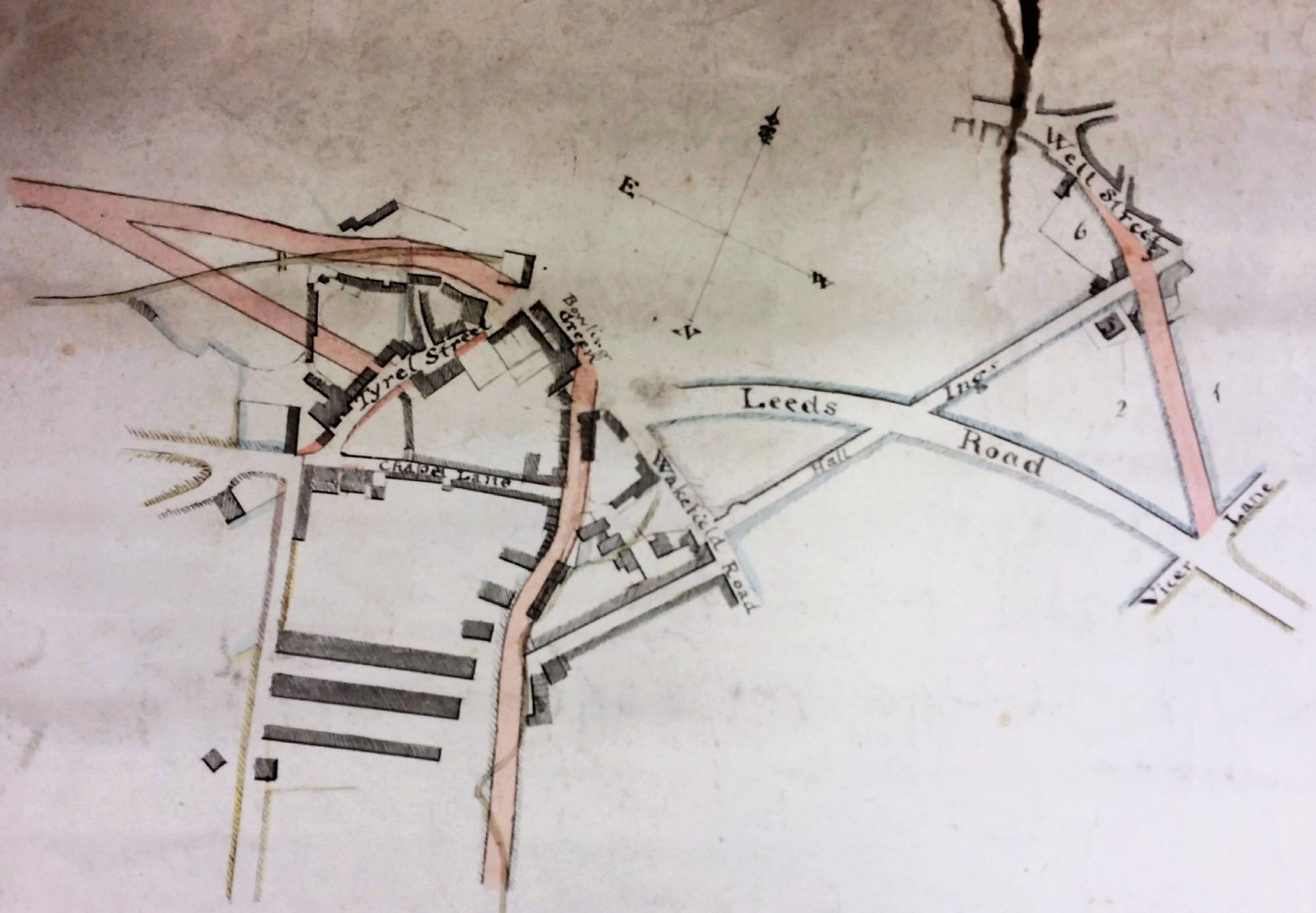
Many maps and plans were drawn prior to planned developments that might, but might not, have eventually taken place. There are two maps in the Local Studies Library reserve collection which evidently were produced to display the same projected roads leaving Bradford to the south and west. Here I have reproduced, as my main image, the map illustrating the town centre.
This map presents many difficulties of interpretation. It is not dated, no purpose for it is indicated, there is no scale, and the compass points are mislabelled, although the arrowhead is pointing north as it should do. In the discussion that follows I shall use the true compass directions. The map is annotated with the word ‘Bradford’ but I think we might have guessed that anyway. Since the map is not easy to interpret, I would be more than usually happy to have my conclusions corrected by anyone more familiar with the evolution of the city’s road transport links.
Dating is the first difficulty. The fact that no railway is included suggests that the map is older than the mid-1840s, but then again neither is the canal (eighteenth century) or parish church (medieval) included. Possibly these simply did not interest the anonymous surveyor. A good place to start is with a building that is present, the Bowling Green Inn. This was a hostelry that once stood on Bridge Street. Cudworth mentions that in the 1830s its owner was a Mrs Susannah Ward, widow of Joseph Ward. On-line masonic records suggests that the Bowling Green Inn was in existence in the late eighteenth century (c.1794) and William Scruton, in Pen & Pencil Pictures of Old Bradford, pushes that date back still further into the seventeenth century. He regarded the Bowling Green as ‘the best inn of the town’. It was used by the Royal Mail, and the open space in front of the inn was employed for political meetings.
The named thoroughfare directed south-east from the Bowling Green must be Bridge Street, although it is here labelled Wakefield Road. The real difficulty comes with the pink road directed southwards from the bottom centre of the map. Is this intended to be Manchester Road? No, Manchester Road must be the unnamed straight highway ending at the junction of Tyrrel Street and Chapel Lane. The pink road seems to be following the course of the Bowling Beck, and the watercourse is presumably indicated by the superimposed faint wavy line. The beck is now culverted, but I believe it does lie well to the east of Manchester Road. What is the unnamed linking road joining the pink track to Wakefield Road? It is too far north to be Croft Street, which survives, but it is in the right place to be Union Street which was subsequently lost in the development around the Bradford Interchange. If then I am correct, the pink road itself was never constructed but the second map in the LSL enables one to project its further course. It would have joined Manchester Road, then called Bowling Lane, just before the location later developed as Ripleyville.

As I have said the top right corner of the first map would have been clearer if the parish church had been included. Church Bank is approximately the continuation of the mapped Hall Ings, although much of Hall Ings has also now vanished following development. This second map does include the parish church although it will be too small for you to see clearly. It is easier to suggest a date based on this second map. The Keighley & Bradford Turnpike is drawn (1825). Both maps show that Leeds Road is in existence which dates them to later than c.1825-30 during which period the new turnpike to Leeds was constructed by the Leeds & Halifax Turnpike Trust. The short pink road joining Well Street to Vicar Lane in the first map was certainly constructed, and still survives. It also took the name of Well Street and, resurfaced, it is now placed between Little Germany and the new Broadway shopping centre.
If you return to the ‘bowling green’ you can see that, after a short gap, another road leaves westwards, and this has two origins. I wondered if this was approximately the track of the future Thornton Road (constructed 1829). This could work if Great Horton Road is the unnamed thoroughfare making a right angle with Manchester Road, but the pink tracks seem to start too far north. Another superimposed faint line marks, I assume, the course of the Bradford Beck, in which case the ‘box’ at the end of that mark would then be the Soke or Queen’s Mill. I cannot make the pink tracks fit with any roads I know although, in any case, the street plan here changed radically around 1870 with the creation of Aldermanbury and Godwin Street. The second map brings the planned road to a junction with Brick Lane after which it does continue along the line of Thornton Road as far as I can judge. If I am right both the illustrated maps would seem to date from the late 1820s after the construction of Leeds Road but before that of Thornton Road.

The third map is firmly dated 1825 and makes the first two seem rather amateurish in quality. In the bottom left portion of the first map some terraces are left ‘hanging’ from the unnamed Bowling Lane. One is clearly labelled Hope Street in the third image.
But where would Hope Street be located now? It must have run across Jacobs Well (now a car park since the demolition of the office building). The road parallel to Hope Street, and placed just beneath it on the map, is Kent Street. Remarkably this road has survived the vicissitudes of the 19th and 20th centuries until the present day, with the Jacobs Well Pub (1830) being its last surviving building. This, rather awkwardly, puts Hope Street (which as I say is immediately north of Kent Street) in the middle of a modern main road (Hall Ings) somewhere near the Jacobs Well roundabout. I cross this roundabout every time I visit the Local Studies Library. The street name does not survive in modern Bradford which is a pity since hope is surely what we need in these troubled times, as 2021 passes into 2022.

Hi Derek,
Is the first pink road that you mention not the widening of Nelson Street? If you look at the 1852 OS map, Nelson Street is a narrow, short road that leads from Chapel Lane and then meanders a little. However, by the 1893 OS map, it is a wider thoroughfare, that ultimately runs parallel with Manchester Road as it does now (and as it does on the first map that you have posted).
I’ll have a think about the others (Thornton Road sounds likely though).
Fantastic maps as always!
Kind regards,
Kieran
LikeLike
have you any info on hall ings because dr swaine and daughter lived there and wonder also when he died. also samuel swaine died 1808 but by this time he had already built the house adjacent to john rands mill per cudworth. wonder where he went after he gave mary and john rand his house to dau and son in law. In addition heywoods book says 1755 samuel swaine built a house at little horton lane. listed buildings state 41 43 44 little horton lane later on owned by faith sowrey of swaine booth sculduggery but states built 1775 which does not match up with cudworth book and i know cudworth will be right -any info?
LikeLike