
1.02 ECC 1842 ALE
Material: Paper booklet Scale: 5 chains:1in
Size: 25 * 35cm Condition: Fair
You may have noticed that in this series of maps I devote a good deal of space to complaining about the lack of plan dates, and the reluctance of map surveyors to explain the purpose of their productions. Not on this occasion. This map was printed in 1842, and dealt with the sale of freehold plots at Eccleshill. We even have the sale booklet (see the final image). This sale of 33 lots must have arisen from the operation of the Enclosure Act in Eccleshill. I believe enclosures took place on this area between 1827 and 1848, which is quite late for the Bradford region. The enclosure of Heaton Moor, for example, took place in 1780, and nearby Bolton Common in 1819.

I would call the area involved Undercliffe rather than Eccleshill, but community boundaries were more flexible in the past. So, where are we? Identification is made slightly easier if the map is rotated 90 degrees to the right. The unnamed road at the bottom of the map is modern Idle Road. At the bottom right there is a junction between this road and the turnpike (modern Harrogate Road) is now by Peel Park Primary School. Today these two roads are linked by Valley View Grove (A6177) but this had not been created in 1844. But Dudley Hill Road and Wellington Road (then called Bolton Road) were present and Stone Hall Road is in the same position today. On the left-hand side of the map much of Lots 21-23 are occupied by Wellington Primary School today. Today Idle Road, Undercliffe Road and Pelham Road form a very prominent triangle as they do (under different names) on our map, surrounding lot 4.
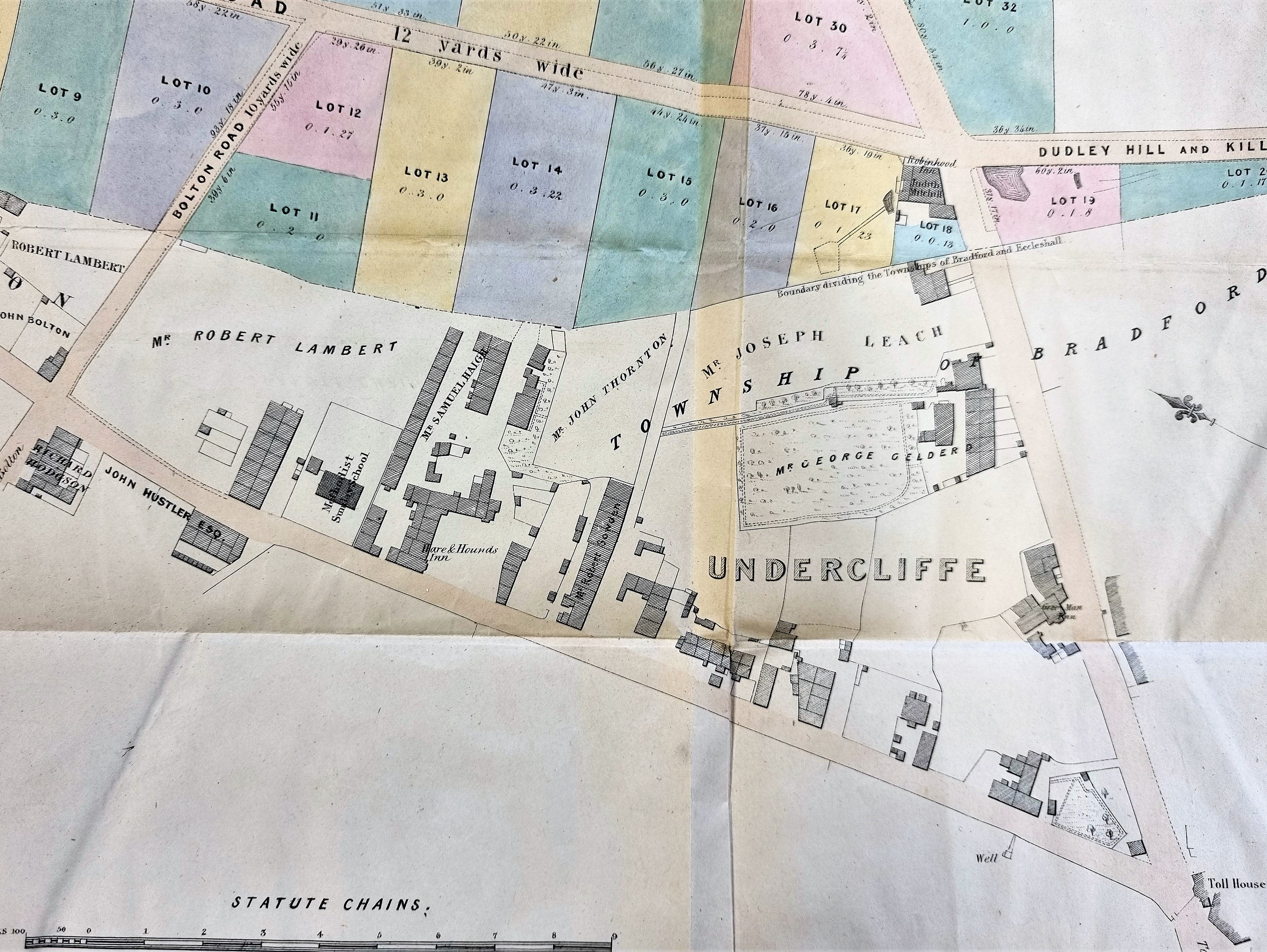
The map records the names of a number of local landowners: John Bolton, Robert Lambert, John Hustler, Richard Hodgson, Samuel Haigh, John Thornton, Joseph Leach and George Gelderd. This last name sounds rather unusual, but I can’t trace him in contemporary census returns. A Samuel Haigh, farmer of Undercliffe born in 1791, and his wife Jane are in the 1841 census. Samuel Haigh’s death is reported in the Bradford Observer on 19.08.1847. A man of the same name, also of Undercliffe, is on my list of Bradford brickmakers. Are we looking at a single individual? Of all the names John Hustler is the one I associate most closely with Undercliffe. The famous Quaker canal promoter of this name, the builder of Undercliffe House, had died in 1790. He had a son (died 1842) and a grandson of the same name, the latter (Cudworth reports) purchased Bolton House. Either of these two could be the man recorded on the map.


Hi Interesting map, especially how the area(s) is/are referred to.
Would Samuel Haigh be the person Haigh Fold (off Moorside Lane) is named after? There is an old Hall there that dates back several hundred years, and is in Eccleshill.
A path (until the new development, but detailed on the A-Z) ran through Haigh Fold across to Green Lane (off Fagley Lane) that then led down to Ravenscliffe Woods, up to Woodhall Road, across to Priesthorpe Road down to Pudsey and beyond.
LikeLike