X54 ECC c.1840 DIX
Size: 19” * 23” Material: Paper
Date: unk Scale: 10 yards to 1”
Condition: good
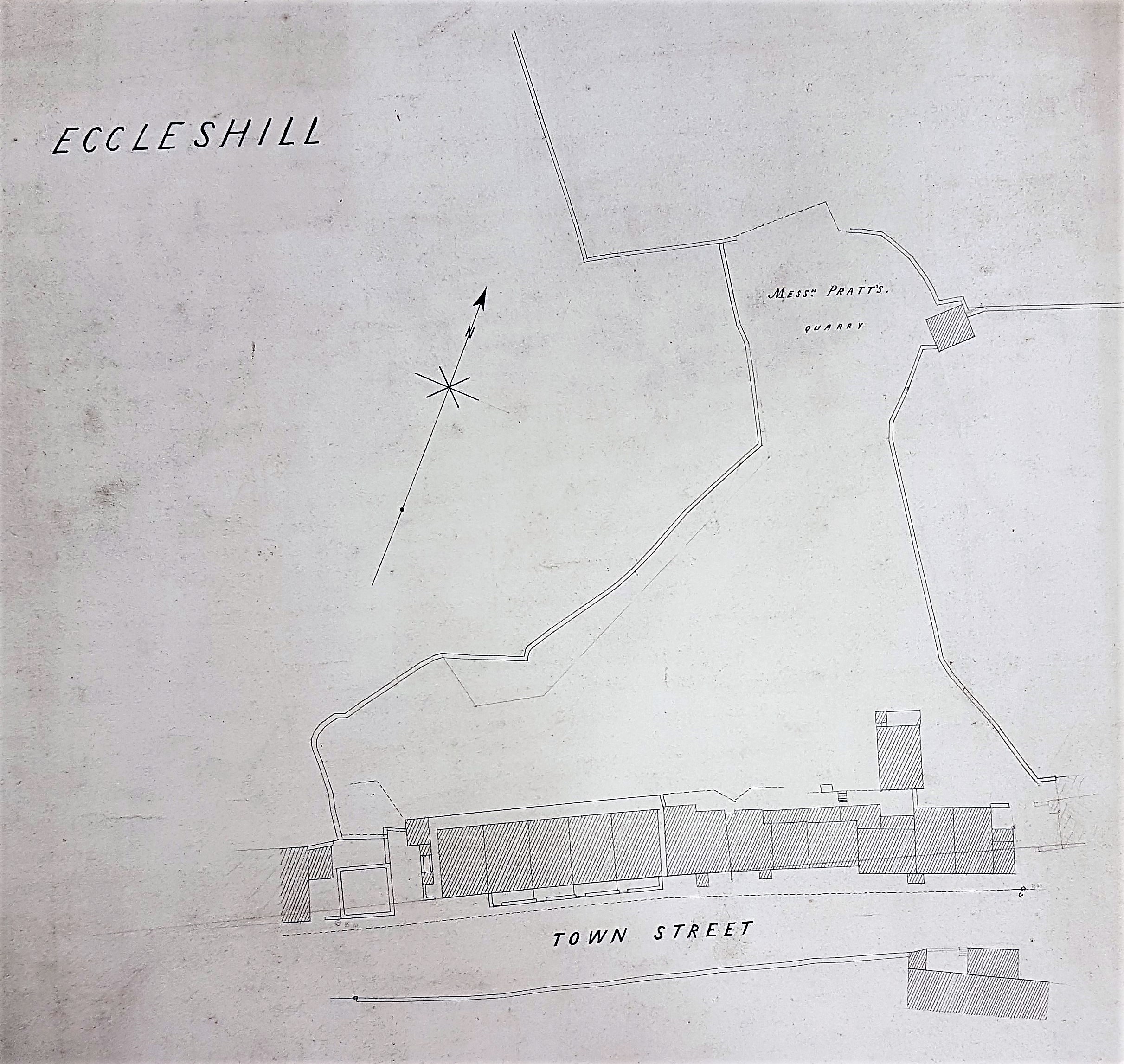
The poet tells us that we can see ‘a World in a Grain of Sand’, but can this small grain of a map add anything to our knowledge of the history of Eccleshill, perhaps the Bradford area’s oldest community? It’s not a place I know well, and the plan is undated, contains no indication of its purpose, and has little information to assist in identifying the location surveyed. I know however that if my conclusions are mistaken there is a highly knowledgeable Eccleshill historian, and reader of this blog, willing to offer corrections.
The plan was surveyed by the well-known partnership of Dixon & Hindle, and includes ‘Messrs. Pratt’s quarry’. So, the first problem is locating the roadway described as ‘Town Street’. I assumed that this is not to be confused with Town Lane in the neighbouring community of Idle. Unfortunately, I don’t know a Town Street in contemporary Eccleshill and none features on the modern Eccleshill Historical Map. Today the Eccleshill village centre is really Stoney Lane, which connects Stone Hall Road, Moorside Road and Victoria Road. Most of the early maps of Bradford itself don’t extend much further north than Peel Park, so they are not very helpful.
The lovely 25” OS map of Eccleshill from the 1890s also uses the designation Stoney Lane but the field boundary and building patterns closely match our plan. In which case Messrs. Pratt’s quarry evolved into Stoney Lane Quarries which were evidently quite a large concern. Having made that probable match, I turned to the 6” Ordnance Survey map prepared in the late 1840s. The roadway is present there and is called Stony Lane; the quarry, reasonably enough, is Stony Lane Quarry (note the slight variation in spelling). The quarry looks more extensive on our plan than in the OS map, so I deduce our plan is older, and I shall assign the date of c.1840 to it. That Stony Lane was previously called Town Lane is confirmed by the Eccleshill section of William Cudworth’s Round About Bradford. He places Town Lane between Eccleshill Bank and Stone Hall which is good enough for me. The vista from the street may not have been very pleasant. Cudworth describes its buildings as ‘erections of various degrees of ugliness encroaching on a narrow and tortuous main street’.
Why was the name changed? Possibly because of the increasing popularity of the postal service: there were probably just too many Town Lanes and Town Streets. The was another in Heaton, which is now called Highgate.
What were Messrs. Pratt quarrying? That is straightforward. The whole of Eccleshill was once extensively mined for coal, and quarried for stone and fireclay. This is now quite hard to believe but mining features are commonly seen on nineteenth century maps of the district. The coal seams that could be accessed included the Hard and Soft Beds (sometimes called the Upper and Lower Beds) which were widely exploited all over north Bradford. Above these in the geological sequence was the important vein of sandstone called the Elland Flags, which was extensively quarried for flagstones and ‘roof slates’. The well-known George Vint, with his various partners, owned large quarries in nearby Idle extracting this same valuable rock. Cudworth again, in his account of Eccleshill, describes at length a fire-clay and brick making industry based at Manor Potteries in Eccleshill. Sadly Messrs. Pratt do not feature in his account.
Since writing the above paragraphs I have been most grateful for the guidance of noted Eccleshill historian, Ken Kenzie. He confirms that Town Street was between Eccleshill Bank and the Monkey Bridge/White Hart.
Stoney Lane was also known as Briggate, and the end nearest the Monkey Bridge was Lower Briggate. Town Lane, now part of Victoria Road, was between Monkey Bridge and Chapel Street. Both Town Street and Town Lane became Victoria Road at the time of Queen Victoria’s Golden Jubilee in 1887.
The ‘Pratt’s quarry plan’ is actually showing a part of Stoney Lane (that is Town Street on the plan). The enclosed square on the left is the Pinfold, now a fishing tackle shop. The four houses within the nearby oblong were Lot 1 in the sale of John Edmondson’s estate in 1884. In the sale catalogue it was named as Ashfield Terrace. It became New Briggate, and is now re-fronted shops Many of the buildings shown are still standing.
Pratts quarry itself is now the area between Norman Lane and the burial ground on which Institute Road and Post Office Road were built. The remainder of the land, is still – in local parlance – ‘t’Delph Hill’.

Naaa Tha’s wrong lad…. Norman Lane – Town Street – Town Lane… Town Street & Town Lane we know today as Victoria Road from the Victoria Hotel at the top of the ‘Bank’ 😉
LikeLike
Having said that – Placing the map on Stoney Lane does fit the profile / footprint for that period and the blank square area to the far left fits nicely with the old ‘Penfold’ 🙂
LikeLike