X28 BRA c.1845 WRI
Size: 12” * 19” Material: paper
Date: unk
Scale: 20 yards to 1” Condition: good
The ‘Rev. Godfrey’ listed as the owner on this plan’s provisional index card is Godfrey Wright. If you have explored even a small number of these Local Bradford Local Studies Library maps with me this name will be very familiar to you. But, just in case you haven’t, I should explain that that Rev. Godfrey Charles Wright (1780-1862), of Bilham House, Hooton Pagnall, Doncaster, is now an almost entirely forgotten figure but was once a major Bradford landowner. He possessed estates in what would later become the city centre, but also at Horton, Manningham, Baildon, Otley, and elsewhere. The first of his appearances in the local press I can trace is from 1819, when he subscribes two guineas to Leeds General Infirmary. At that date he is already being referred to by his clerical title. Godfrey Wright does not seem to have lived in Bradford for any prolonged period, if at all. His wife died in 1821 and certainly by 1822 he was resident at Bilham House, where he remained for the next 40 years. In later census reports he described himself as a ‘clergyman without cure of souls’. He normally had an indoor and outdoor staff of a dozen or more, so his exposure to clerical poverty was probably limited.
Wright was still living (with 10 servants) at the time of the 1861 census, but he died the following year. He was described as a staunch Conservative and left £80,000 to his heirs in 1862 which equates, according to the National Archives currency converter, to £3,452,800 at 2005 values: more now of course. It is very natural to wonder how an unpreferred Clerk in Holy Orders acquired all this wealth and property. Victorian Bradford historian William Cudworth believed that Godfrey Wright’s prosperity resulted from a relationship to, and inheritance from, three important local families: the Swaines, the Fields, and the Booths. By the mid-1800s his agent was Thomas Hirst of Hall Ings, Bradford. To the best of my belief in 1850 he owned the land on which a Public (St George’s) Hall was built and got £15,000 for it (Bradford Observer October 17 1850). He also owned ‘Colliers’ Close’ which evolved into Little Germany and the Bradford Observer, February 26 1857, reported that he also owned possessed The Beehive and ‘low’ dwellings in the Silbridge Road area.
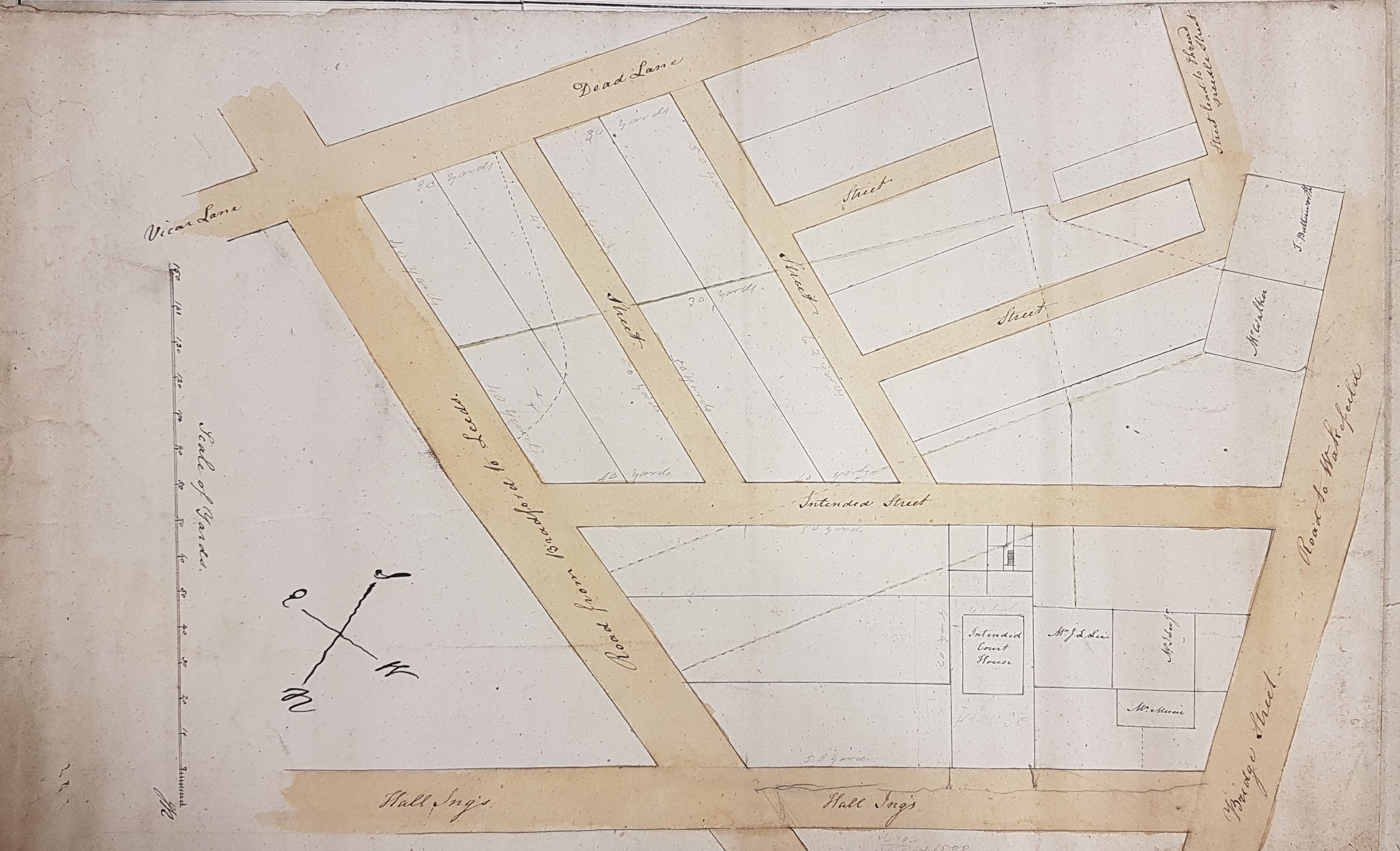
This plan is undated but, as you will see, it must have been drawn up between 1834 and 1850. It is very difficult to orientate the plan into a position where everything written on it is readable. It may be easiest to put Bridge Street – Wakefield Road at the bottom. Hall Ings is clearly marked, but in reality is directed NE. Half-way along it cuts the ‘new’ road from Bradford to Leeds (now Leeds Road). The road running very roughly parallel to Hall Ings, on the opposite side of the plan, is Vicar Lane, although a section of it is described by its old name of Dead Lane. If we compare the rest of the plan with the Rapkin Map of Bradford (c.1854) it can be seen that the ‘intended Court House’ was indeed built, but instead of most of the network of roads there is a railway terminus! The only road actually constructed was the first one after, and parallel to, Hall Ings – which was named Drake Street. A railway line from Halifax to Bradford via Low Moor was built by the Lancashire and Yorkshire Railway in 1850: this ended at ‘Drake Street station’. This terminus was later called Exchange Station, and the L&YR became part of Great Northern Railway.
At the corner of Bridge Street and Hall Ings St George’s Hall was to be built. As I said I believed that Wright owned all the land on which the hall was constructed but if this is correct the other names written on plots (which won’t be readable) must be occupiers rather than owners. I’m sorry not to have been able to walk along the ‘street leading to Threadneedle Street’. The 1834 Bradford map suggests that the whole area was largely wooded, with few buildings, but does include the course of Threadneedle Street, although this (with so much else) has long been swept away.

Given that the Court House is shown as “Intended Court House” the plan must be pre-1834 (as the Court House was completed in that year). Godfrey Wright had owned the Court House land – he was paid £1,018 1s 7d for it. You are correct that Godfrey Wright owned the St. George’s Hall site – in 1850 it was occupied by a Mr Poppleton and a Mr Byron
LikeLike