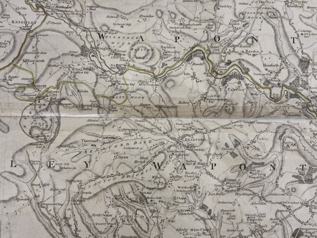
We are fortunate to have quite early plans of portions of Bradford, drawn for legal or land-ownership purposes. Horton, a part of Heaton, and Manningham are recorded in this way. To the best of my knowledge this 1771 map of The County of York by Thomas Jefferys is the first that shows the whole of Bradford and its surroundings. Jefferys (1719 – 1771) was the leading cartographer of his day. He produced a series of maps of the English counties and this one was published right at the end of his life. The York map was dedicated to Charles Watson Wentworth, Marquis of Rockingham. The details here are taken from Sheet 7. The names of principal landowners and their seats are provided, possibly because they were a likely market for sale of the maps. The map predates the railway lines but some turnpike roads already exist. They Leeds-Liverpool canal is drawn, although it was only under construction in 1771. There is not yet a canal spur to Bradford (opened 1774).
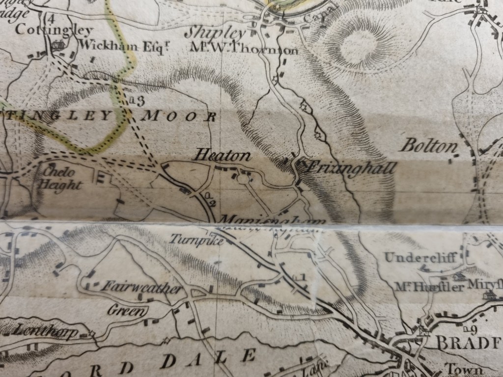
What I don’t know is how accurate we can expect the map to be. In this detail the turnpike leaving Bradford to the north-west must be Westgate – White Abbey Road – Whetley Hill and Toller Lane. At ‘Manningham’ the right branch eventually splits into two roads marked by parallel interrupted lines, which must surely be modern Haworth Road (to Chellow) and Bingley Road (to Cottingley). Halfway along this section is a right turn to Heaton which must represent modern Leylands Lane. Heaton itself is represented by a cluster of blocks, but it surprising that Heaton Hall (a Queen Anne mansion) and its owners, the Field family, do not rate an individual mention. The blocks cluster round a circular feature in the area of Heaton Syke. Was there ever a village green in this position? In several parts of the map woodland is indicated by rather formal looking trees (Hirst Wood or Buck Wood for example). Nothing of the sort is representing Heaton Woods; could they be entirely a later plantation? No coal mines or quarries are identified, although they certainly existed in 1770. Along the unnamed Bradford Beck between three ‘sun-like’ icons which must represent watermills. There is another in Shipley and two at Hirst Wood in the River Aire. In Eccleshill there is a windmill.
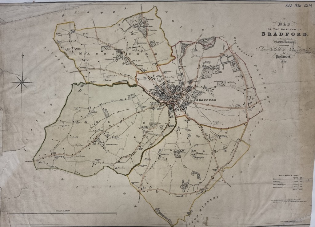
The next map was published in 1834, two years after the date at which Bradford became a parliamentary constituency. Ellis Cunliffe Lister and John Hardy were the MPs at that time. It is a far more satisfactory map although direct comparison with what I have just discussed is difficult since Heaton and Shipley were not then part of Bradford. The town is fully integrated with the canal system but the there are still no mines or quarries marked, although there is a ‘Pit Lane’ near Eastbrook House. Industry does feature with a gas works, a vitriol works, a dyehouse, and the iron works at Bowling with attendant mineral ways. The map doesn’t extend as far as Low Moor Iron Works but there is one of Low Moor’s mineral ways which ends in a long forgotten coal staithe just south of Little Horton. A cross marks the position of the parish church, and the new Leeds Road has been constructed.
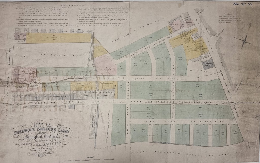
The final map is presented as a reminder of how much more information is contained within sale plans, which is why I provide so many of them. Three years after the 1834 parliamentary map Samuel Hailstone is selling off his land in the town centre. As you can see we are in the area of Goodmansend and Bridge Street. You can find Bridge Street on the Parliamentary map and another cross marks the location of the Friends (Quaker) Meeting House. Then compare the two maps!
