
I have used this city centre plan of Samuel Spence’s estate before, but I now see that it needs a more detailed treatment. The Local Studies Library has a number of other maps and plans of this area; using my second plan in conjunction with the first may make the situation easier to understand. The two plans exemplifies how much the city centre has changed in 175 years. Look at the site of the Bowling Green Inn for instance. The Bowling Green Inn, together with its brewhouse, stable, gig house, and other ancillary buildings had long been part of the town centre. It was demolished some time shortly after 1862 I believe. What happened next? The Inn was pulled down to make way for the Mechanics’ Institute. But, remembering this is Bradford, the MI was later pulled down to make way for Provincial House, which in turn was pulled down to make way for the present curved building occupied by a pub and various eateries.

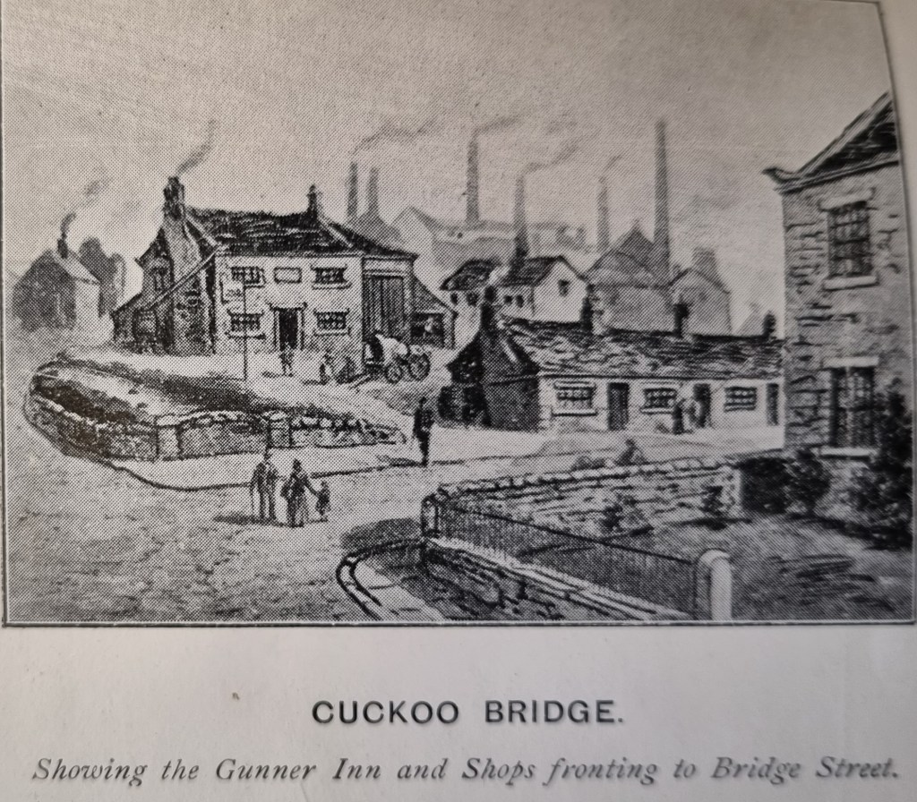
Perhaps we should start with bridges since both plans have one each. There were two bridges close to the end of modern Bridge Street. We have a road name ‘Sunbridge’ which suggest that a bridge was close to the Sun Inn. The famous ‘Sun Inn’ at the bottom of Ivegate was demolished in 1895 and was replaced by the Prudential Assurance Building, so we know where that was. Nearby there was Cuckoo Bridge roughly where Britannia House is located now, formerly the site of the Gunner Inn. Cuckoo Bridge spanned Bowling Beck, which yards further on joined Bradford Beck. Cuckoo Bridge is on the Spence plan and the LSL also has this illustration. Finding the bridges won’t be easy: the Bradford Beck is culverted, and the bridges and all the surrounding buildings have long since been demolished.
The third town centre bridge was further away and does not feature on either plan. It was Church Bridge and was nearer the present site of the cathedral near the Forster Square end of Market Street. It was also known as Bradford Bridge.
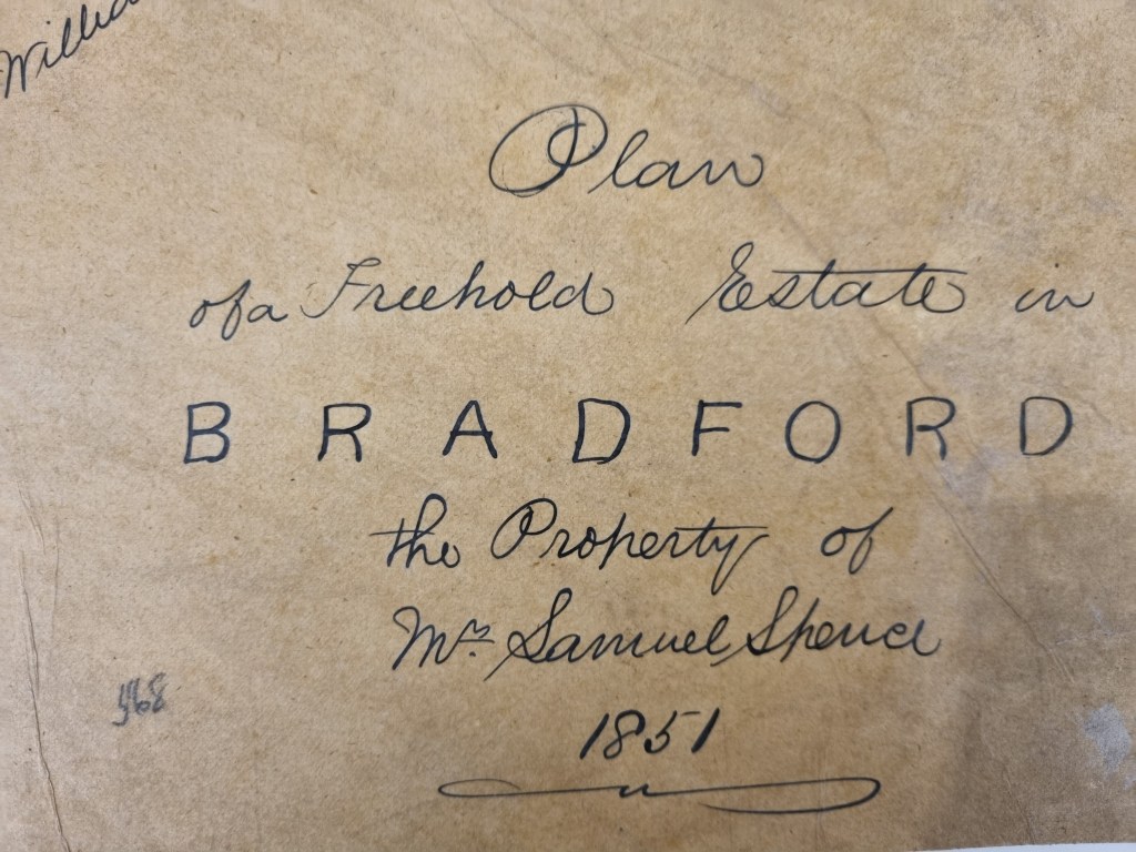
Returning to the Spence estate plan shown in the first figure you can see that in gives us the definite advantage of a date – 1851. It is not clear why the map was drawn up. Samuel Spence had not died and the map, valuable though it is, looks a little amateurish for a sale plan. There is a list provided of the various buildings drawn, and the acreages occupied.

Note the ‘mill and chimney’; what type of mill would this have been? One contemporary trade directory entry places Spence’s Mill in Chapel Lane with the owner having a house in Eccleshill. Another describes Samuel Spence as a hay, straw and flour dealer with premises in Nelson Street and a house in Chapel Lane. The 1851 census return has a 50 year old Samuel Spencer, corn miller and mill-owner, at 29 Victoria Street. I’m glad that census reports and BMD data suggest that Samuel Spence lived until 1870, dying in Duffield, Derbyshire.
Using the 1848 surveyed Town Map in conjunction with these plans makes it clear that there were also two iron foundries and two worsted mills in the vicinity as well. In the nineteenth century town centre between Nelson Street and Chapel Lane, was the Unitarian Chapel, which in two constructions was there until the late 1960s. On the opposite side of the road there were once two iron foundries, the Old Foundry and the Union Foundry. The Old Foundry, had access from a private road to Tyrrell Street. This would place the site where the Mirror Pool is today. The site was compulsorily purchased by Bradford Corporation in the 1860s to allow for street improvements.

One of the other values of the Spence plan is that it gives the name of neighbouring landowners. The ‘Misses Rawson’ were the daughters of Benjamin Rawson. Benjamin Rawson (1758-1844) was a wealthy businessman who purchased the Lordship of the Manor of Bradford, a role in which he and his two daughters, Miss Mary and Miss Elizabeth Rawson, will be familiar to local historians. Elizabeth was Lady of the Manor of Bradford until she died in 1899. She lived at Nidd Hall near Harrogate.
Physician William MacTurk or McTurk MD (1795-1872) lived at 29 Mannor Row and was a well-known Bradford doctor. He died a wealthy man and evidently owned estate within Bradford. He was also renowned for his philanthropy, establishing a new church in Manningham, and being closely connected to Bradford Grammar School. Dr. MacTurk continued to visit Charlotte Bronte throughout her pregnancy and final illness, and it seems that he had also treated Branwell Brontë for the effects of alcoholism.
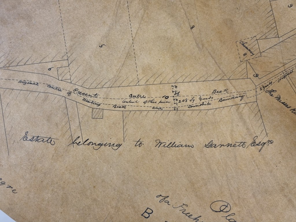
William Garnett (1813-1888) is present in the 1851 census at Hillside, Barkerend. He is a 38 year old worsted spinner who employs 800 men, 50 women and (rather ominously) 500 children. He was the son of James Garnett, who I assume was the James Garnett who made Paper Hall the location of the city’s first spinning machines in 1794. He later moved to Sharow near Ripon. I assume he was also related to John Garnett Horsfall who had introduced steam power looms to Bradford, which led to a riot at his mill at North Wing (1826).
When I last present the Spence Plan local historian Kieran Wilkinson reviewed contemporary newspapers and found numerous references to Spence being based on Chapel Lane, effectively ruling out any connection with Nelson Street. A suggestion that his mill didn’t have a single function seems correct. Kieran found rooms being let out for wool combing. It would appear that Samuel Spence owned a substantial block of property between the Cuckoo Bridge and the junction of Chapel Lane with Nelson Street but how he came by it I do not know.
