
This map (5.019 H) records an area south of Rooley Lane. It is drawn on waxed paper and is associated with other plans whose ultimate origin seems to be Bradford City Council. A 1959 date is written on one area of the map. Originally, I gave this plan a date of c.1960, but this must be at least 5 years too early. Although the original map seems to deal with property and field boundaries, additional information has been subsequently added. Some of this reflects the use to which the fields are being put. It is a detailed plan of the area identifying farm names and associated fields. Pig-breeding, and dairy herds are marked. ‘TT’ herds indicates ‘tuberculin tested’: this designation was introduced pre-War but must be post 1935. There are also planned road developments marked in broken red lines. The plan is annotated with ‘information from geology map’. Surprisingly, but interesting to me, it records a good deal of detail of this type. Perhaps this indicates areas to be avoided during the envisaged road construction.

I have tried to get the exact location by comparison with 25” OS maps of 1895-1908. The above detail is straightforward since it shows the junction of Rooley Lane and Bierley Lane. At the extreme top is a rectangular building labelled as ‘vicarage’, but the associated St John’s Church is not drawn. Moving left (west) along Rooley Lane is ‘cemetery farm’, at the entrance to Bowling Cemetery, and then Newhall Farm, south of which is West Bowling Golf Course. Shale and coal beds are marked in red, and also the position of a geological fault running SW to NE. Best of all is the site of Jordon coal and ironstone pit, which I assume was once one of the many pits supplying Low Moor Iron Works.

This detail joins to the SE of the previous one. Bierley Lane is now to the left, ending at Tanhouse Farm with its TT (tuberculin tested) herd. To reach it you pass another disused pit. The big feature on this plan is the ‘disused railway’. It is a true railway line, not one of the many ‘mineral ways’. This line was marked ‘under construction’ on the 1893 OS map, but by 1905 it is the Pudsey and Low Moor branch of the GNR. It apparently joined the main Bradford-Leeds line to Pudsey Greenside and Laisterdyke. It closed in 1964. Shetcliffe Lane is top right, and of course still exists. The planned ‘outer ring road’ I don’t recognise, perhaps it was only a gleam in a planner’s eye?
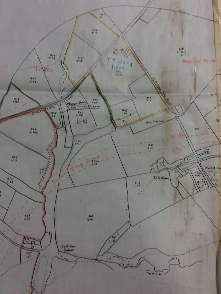
The next detail takes things slightly further east and there are two more TT herds. Toftshaw Bottom, at the base of the plan, was a place where several mineral ways once converged. These are long vanished of course but it would appear that the earthworks associated with them remained.

The final detail takes you further west than figure 3. There are more pits and herds, and bottom right more of the fault leading to Cheesecake House Farm.
After the original publication of this map noted local historian Mary Twentyman was kind enough to send me her recollections:
‘This week’s map is delightful for us Twentymans. My husband Geoff’s dad was Bowling Cemetery Registrar from 1963 until he retired, and for me it shows the way to my grandparents and walks my granddad took me on. We lived down Manchester Road and would walk through West Bowling to Parkside Road and come up Turkey Bird Lane which is still there and comes out now by St Matthews School on the M606 roundabout. I was surprised to discover no one else called it Turkey Bird Lane – but our family did, and we always fed the turkeys in the allotments as we went past. If you went straight ahead you were on the Waggon Road or Staygate/Staithgate Lane – I was never sure which was its proper name. We went blackberrying down there and the highlight of the first day of the new millennium was when Geoff and I went on a walk down there and by trespassing through Odsal Wood we found our way onto the blocked out route. I think it’s covered by the Astonish factory now. There was a Mission Church at the end of the lane and I think a red brick air raid shelter. We used to walk a bit further on Rooley Lane and climb over one of two stiles to make our way through the fields to grandparents’ house on Broughton Avenue. The path got diverted at one time when the Golf Club either started or expanded.
My granddad used to walk me through the fields down into Bierley Woods to the cave and Druids Circle. There was a farmyard at the top of Broughton Avenue. I can’t make out
the name on the map, but the farmer was called Wright Gill. That was his Christian and surname. The gap shown between the semis was a wilderness – not sure why it wasn’t built on, but in the war my mother said a German plane swooped down and flew through it and they thought he was going to drop a bomb on them.
The disused railway line came down from Westgate Hill towards Low Moor past Merrydale. My mother told a tale of getting into bother when she took her baby sister in a pram on a walk down the side of the tracks. She got on by the level crossing at Westgate Hill where she lived as a child and fortunately was apprehended before any trains came!
The last walk with my granddad was to see a barn fire at Tan House Farm (our family loves watching fires!) He died a few days later. I think Toftshire Bottoms may be the place my mum called Jinnys-it-ole. That’s how she said it. I think it was the place where there had been a coal winding Gin.
Thank you for bringing back some lovely memories.’
