Regular readers of this Local Studies Library page will know that two of my minor obsessions are Victorian landowner Rev. Godfrey Wright and Bradford’s coal industry. In this instance the two are seemingly linked through a coal staithe. A coal staithe (staith or stay) is a place adjacent to a highway, railway track, or habour from which merchants can collect a supply of coals of various grades for subsequent delivery to their customers.
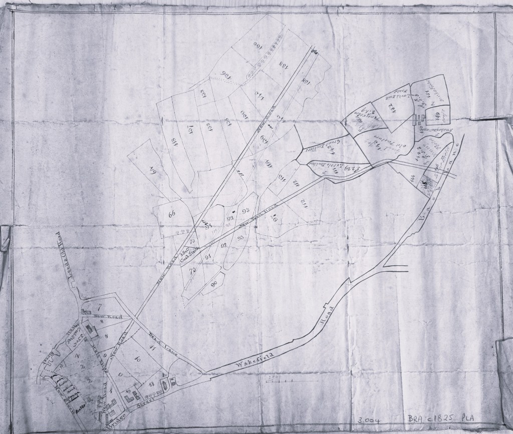
The two central Bradford 19th century staithes are marked J.S. & Co. and J.J. & Co. These initials must represent John Sturges (or Sturgess) & Co. who operated Bowling Iron Works, and John Jarratt from Low Moor Iron Co. These designations are incorporated into the early property map of Godfrey Wright’s shown in the first image. I mentioned the Bowling Iron Company staithe in August 2024; this was on Leeds Road, and was supplied by a mineral tramway. On the first map both road and tramway are designated ‘new’. This suggests that the location of the staithe depended on the construction of the new Leeds Road which puts the date at c.1825.

The equivalent staithe supplied by Low Moor Iron Company is equally interesting. It was located at the corner of Well Street and Hall Ings, and shows well in the above detail of the first map near the top left. I am virtually certain that the plan in the Local Studies Library reserve collection represents Rev. Godfrey Wright’s properties in the east side of Bradford. He owned a great many more properties in the west of the town and in Manningham. How did a coal supply reach the staithe? There is no room for a tramway so I can only postulate deliveries, a massive number of deliveries, by horse and cart.
When was the staithe established? Dr Simon Valentine in an essay on Methodism in Bradford (Aspects of Bradford 2, ed. Bob Duckett, 2000, Wharncliffe Books) states that William Grimshaw, perpetual curate of Haworth, was not allowed to preach in Bradford parish church, Instead, he spoke in the open air ‘his particular area being a spot afterwards occupied as a coal-staith in Well Street’. Grimshaw died in 1763 so we can be reasonable sure that the staithe was established later than the mid-18th century. My guess is that both staithes were established together with Leeds Road, so c.1825.

Are there other maps that show this area? The image above must also show Godfrey Wright’s possessions since the plot numbering is identical. The coal staithe is adjacent to plots 3 and 4. The presence of ‘Leeds New Road’ suggests that this map is of comparable date to the first but there are no additional annotations.
When did the staithe cease operation? I would suggest a fairly short life of about 25 years. The Low Moor staithe is still present on the 1852 town plan of Bradford, which was surveyed in 1848. In this plan the Bowling Iron Company equivalent is definitely an ‘old staithe’. In the roughly contemporary 6”OS map of 1850-52 the Bowling Iron Company site is still an ‘old coal staithe’; there is a building but no staithe at the Low Moor Site. It looks as we have ‘caught’ the staithes in a process of dissolution.
What happened, since the growth of Bradford would have necessitated an increased supply of coal? The answer must surely be a new means of supply through the newly established railways. The town plan clearly indicates a ‘Bowling Coal Dept’ next to the worsted mill in Caledonia Street, and there is an additional ‘coal depot’ parallel to the railway tracks near the Broomfield level crossing.
***
Since this item was first published I’ve heard from local historian and photographer Kieran Wilkinson who has been looking closely at the dating of relevant maps. I am very grateful to him.
As far as the staithe’s end date is concerned, Foster’s Building, which was built on the site was opened, he believes, in 1857.
There is an OS map, which is often referred to as being an 1852 edition, which shows the coal staithe in situ, However the plan was have has to be later than 1852 for at least two reasons – it shows St. George’s Hall (opened 1853) and the Peel Statue in situ (unveiled 1855). John Rapkin’s map of Bradford, which is thought to be 1854 (St. George’s Hall but no Peel Statue) also shows the staithe still present.
More conclusively the Bradford Observer 20 September 1855, in an article about the widening of Well Street, states that ‘a very large warehouse was about to be erected on the property known as the old coal staith’. The same article goes on to refer to ongoing discussions with the Low Moor Company re acquiring land for the road widening so they must have still had an interest at that stage. Of course, the term “old coal staith” implies that its use had ceased by that stage.
.
