As an incomer, and a long-term resident of the north Bradford – Shipley area, there are many parts of south Bradford I find somewhat perplexing. I haven’t posted a plan of Tyersal for some years but this is certainly one area that perplexes me. In what follows the tops of all the maps included are approximately at grid north, and I have modernised the spelling throughout.
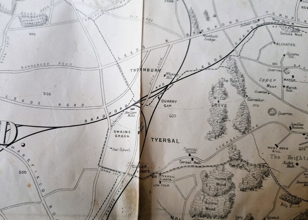
I am starting with a detail from a map included in Victorian historian William Cudworth’s Round About Bradford (1876), a guide to 42 places within 6 miles of the then Borough. Cudworth’s map gives the overall topography of Tyersal in the late nineteenth century. I understand that the old community was considered to be part of Bradford at this time, although some of the district was annexed by Leeds in the 1974 local government reorganisation. In this first plan especially note Quarry Gap, Tyersal House, and Tyersal Hall, all of which will reappear.
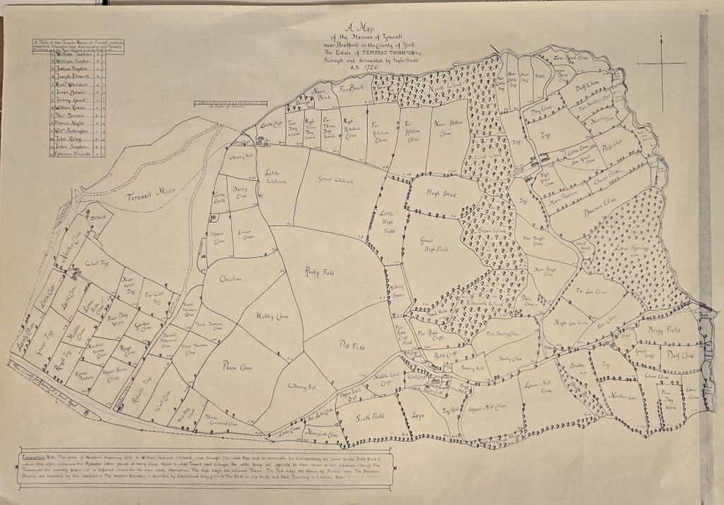
There are three maps in the Local Studies Library which I have recently been studying. Two are early and must be copies. The first is dated 1720: the surveyor is Payler Smith. It shows the manor of Tyersal which it states is the estate of Tempest Thornton Esq. I know that Thornton is a Tyersal surname and the Tempests were an important family from Tong. However, the dates of the only Tempest Thornton my limited genealogy skills can uncover were 1749-1806. These dates do not fit with the one provided for the map but a witness at this man’s wedding in 1770 (in St Martin’s in the Fields) was an Edward Stables, whose surname will shortly reappear.
The rubric suggests that the original plan was coloured. The cluster of houses at the bottom left are Tyersal Hall and Tyersal House, and leaving the map east of this point, at the time of Cudworth’s map, would take you across a railway line and into Cutler Heights. The list of tenants provided would be of interest to local and family historians. The field names give a good deal of information concerning local industry (eg lime kiln close, tenter croft and quarry), and field crops such as clover, peas and barley. Among other names Ings = cleared ground often marshy, Delph = small quarry, Spring = a coppiced tree, Stubbs = tree stumps or stubble, and Shrug = scrubland.
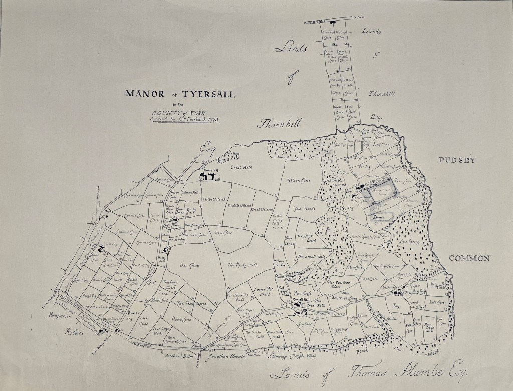
The second map is a couple of generations later (1793). The surveyor is William Fairbank. Thomas Plumbe is mentioned but I don’t think that he is Lord of the Manor of Tyersal. I believe that this man lived at Tong Hall which he had purchased. Other landowners are also named. Field names suggest that coal mining (Pit Fields) and brick-making (Brick Yard) have been introduced to the area.
Cudworth states that the Tyersal manor and estates (636 acres) were sold by auction in 1792 to three purchasers, named Walker, Ingham and Whitacre. Jonathan Walker was one of these three men and he built or rebuilt Tyersal House for himself, which is present on his map. Cudworth further states that for many years a John Drake was the tenant of the hall. These facts were noted by eminent local historian Mary Twentyman who has been working on the Drake family – from whom Rev. Godfrey Wright, once Bradford largest landowner, was descended through his mother.

We have another map of Tyersal in the Local Studies Library reserve collection: dated 1854. This portion of the estate is being sold by the trustees of Mr William & Mrs Jane Stables (remember that surname?) who Cudworth states were only relinquishing part of their holdings. The map is broadly divided, by colour, into occupation by three tenants: Tetley, Hartley and Denison. The Great Northern Railway track is marked on the plan but it is unlikely that the track has actually been constructed by the time the map was surveyed, since the word ‘parts required by the railway’ are employed on the rubric. This track is present on the first Ordnance Survey map of the area from 1852. At that time the line went from Laisterdyke Station via Birkenshaw & Tong, to Drighlington and Gildersome Street.
The whole complex history of ‘The Hamlet or Manor of Tyersall’ was told by Wilfred Robertshaw in 1947 (Bradford Antiquary, Vol. 9. p.161-189, 1947).
