
Since I live in Heaton it is perhaps understandable that I am especially interested in the development of the township and, in particular, how an area noted for farming, stone quarrying, brickmaking, and coal mining was transformed by land sales and villa development. This process was made feasible by excellent road and rail connections to the centre of Bradford. We are exceptionally fortunate since the Local Studies Library has two dated maps recording this process in operation. I shall take them in reverse date order since the more modern map is better for placing modern readers on the ground.
Very helpfully this first auction plan is dated 1874. It is clear that road and house development are being planned. No vendor is mentioned but it is certain that the auctioneers Hardwick, Best and Young are managing the sale on behalf of the Rosse Estate. In 1874 the Dowager Countess of Rosse was Mary Parsons, born Mary Field of Heaton Hall. Her husband, the famous astronomer William Parsons 3rd Earl of Rosse, had been dead for 5 years or so. Lady Rosse, would die herself in 1884, but the Earls of Rosse would own much of Heaton and Shipley for another 25 years, when they sold off all their property.
At the bottom right of the map the Bradford & Keighley Turnpike is the modern the Frizinghall junction of Manningham Lane and Keighley Road. You can see the toll house, long demolished. Opposite is the entrance to Lister Park which Bradford Council purchased from Samuel Cunliffe Lister four years earlier. Missing is the famous Royal or ‘Norman’ arch. The Norman Arch was a testimony to the visit of the Prince of Wales, later King Edward VII, in 1882. It is said to have been constructed from the stone from the demolished Christ Church. Also missing is the large statue of Titus Salt originally placed in front of City Hall, soon after his death in 1876. I believed it was eventually moved to this location simply to improve traffic flow.
The Turf Tavern building, shorn of a few ancillary structures, is still present today but recently became an Asian restaurant. You can still make the stiff climb up Emm Lane to the airy uplands of Heaton village but at the bottom left of the map the route now follows the ‘intended road’ cutting off a decorative triangle of land which has been planted with trees, and daffodils in season. Back to the right of the map you can see the name of the landowner William Lister Marriner. I would guess that the Rosse auction gave him ideas. Today Marriners Drive exists around the perimeter of his former property which is also covered by impressive housing.
Higher up Emm Lane you can see that the new Airedale College is planned. The beautiful Grade II listed building was probably built the following year. It had formed part of the University of Bradford’s Management Centre since 1963 but has recently (2021) been sold. Airedale College was dedicated to the training of Congregationalist ministers; an earlier college had been in existence at Undercliffe since 1831. The carriage drive to the lodge does exist but, higher up Emm Lane, the ‘intended carriage drive’ was not constructed. Higher still the name ‘Park Drive’ is pencilled over the intended road. Park Drive still exists and is known for the impressive beauty of the houses built along it. The property further along Keighley Road, recorded at the top of this map, belongs to Robert Kell (1818-1894). Kell was a stuff merchant whose house, Heaton Mount (an impressive Italianate mansion) had been built in 1864 and also eventually formed part of the university management centre.
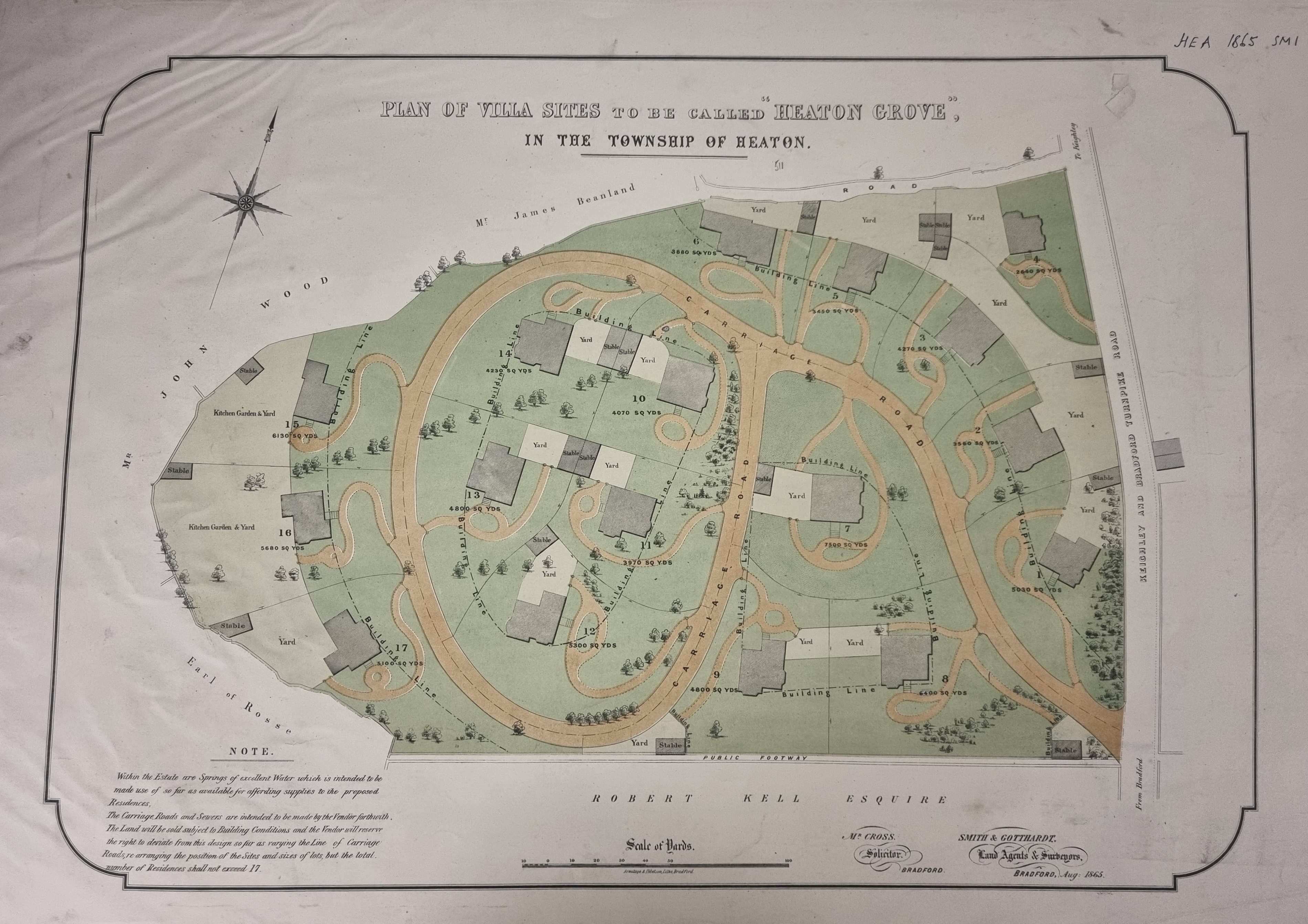
In the second map we have jumped over Robert Kell’s property which now appears at the bottom. The map is almost a decade earlier (1865) and the villas planned for Heaton Grove are clearly ‘top of the range’ with extensive gardens and their own stables. Horses were of course required to pull all those carriages. It is simple to compare the map with the current appearances on Google Earth. Unsurprisingly over the last 160 years several new houses have been constructed on Heaton Grove’s generous gardens!
Again, the vendor is not named but I believe it was Mr James Beanland whose name is at the top of the map. An earlier James Beanland (1768-1851?), sometimes known as James Beanland of Firth Carr, is mentioned by Cudworth since he leased this piece of land for the ‘Woolsorters Gardens’. These were out of town pleasure grounds with baths and a swimming pool. The gardens were founded in 1846 but had just closed by 1865. In the 1841 census James Beanland lived with his daughter Ann Beanland (1806 – 1889), and her illegitimate son James. Ann eventually married a John Bradley when James was 7 years old. She took her husband’s name, but James himself was known as James Bradley Beanland. I assume he is the name on our map. The men mentioned, over three generations, exemplified Heaton history being successively: coal miners, farmers, brick-makers, and property developers.
