
I love this map from the Local Studies Library reserve collection, and I have discussed it several times. If the sales were organised by the office of Samuel Hailstone (1768-1851) then it clearly predates 1851, but not by much since Bradford only became a ‘borough’ in 1847.
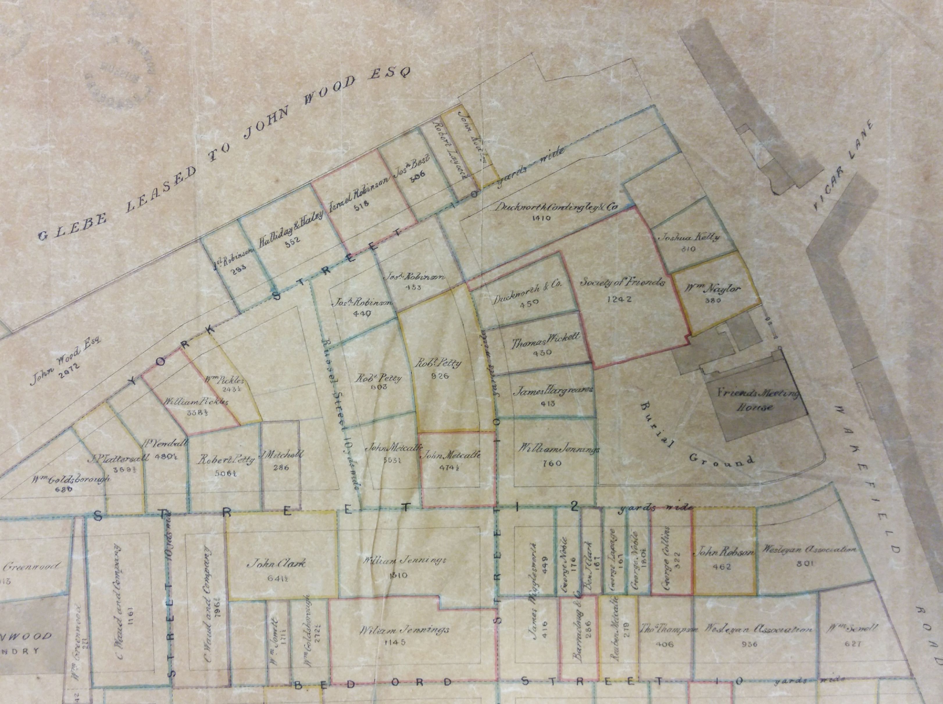
When I first saw the map I assumed that there had been a single land sale of previously undeveloped land, but this theory doesn’t really fit the evidence.
There is an OS town plan of Bradford, surveyed in 1848, which shows the street plan and associated housing almost fully developed. So perhaps the Hailstone plan is the end result of cumulative sales which his office recorded over 25 years. To find the area undeveloped you have to go back as far as the 1834 Bradford plan.
The solicitor involved, Samuel Hailstone, was a lawyer and a botanist. He was born in Hoxton, London but his family soon moved to York. In time he became articled to John Hardy, a Bradford solicitor, and Hardy & Hailstone eventually became partners. John Hardy was elected an MP and I understand that Samuel and John Hardy were the moving spirits behind the 1803 Bradford Improvement Act. More than forty years before Bradford became a borough this act established commissioners with a variety of local government powers such as street cleaning, lighting, and water provision. Samuel Hailstone was the classic example of a wealthy and highly successful professional man. His politics were Liberal and, slightly unusually for non-conformist Bradford, he was an Anglican. He helped found the Bradford Literary & Philosophical Society, also the Mechanics Institute. He served as a major in the Bradford Volunteer Infantry and was clerk to the Trustees of the Leeds and Halifax Turnpike Road and other committees and organisations. In 1808, quite late in life, Samuel married Ann Jones the daughter of a Bradford surgeon, and the couple had several children. He died at Horton Hall, Bradford in 1851.
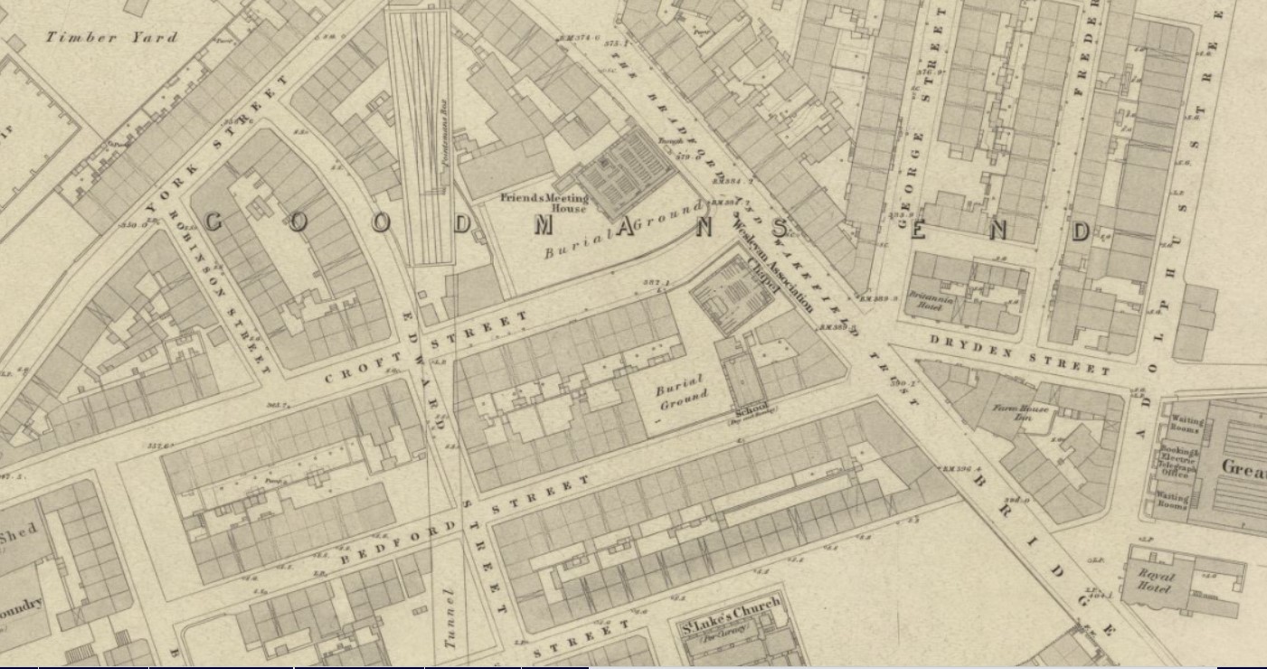
Recently I have been using his map as a resource for a study of Victorian places of worship in Bradford. At the top right of the second image is the meeting house of the Society of Friends (Quakers). This part of Bradford was known as Goodman’s End and the meeting house had been built here in 1811 and enlarged in 1825. It was finally closed in 1877 when a railway company purchased the site.
South of the meeting house you will notice that plots of land had been acquired by the Wesleyan Association. A Bridge Street Chapel was constructed at this location. Lund’s Directory of 1856 puts a Wesleyan Association Chapel on Wakefield Road – but I assume that this is the same building. Other sources suggest that a building, although perhaps an earlier construction, was being used for Methodist worship here as early as 1838. Bridge Street Chapel closed in 1910 and the 1915 OS map reveals an unexpected transition to a ‘Picture House’. The resulting Picturedrome (Astra after 1949) closed in 1956 and was demolished in 1959.

On Portland Street were a row of cottages belonging to John & William Rand. John & William Rand founded their company, an early worsted mill, in 1803. The fame of the name is largely the responsibility of John Rand jnr. (1793-1873) who was a noted businessman and philanthropist, living at Wheatley House and other locations in Manningham. Close to their cottages was the premises of C. Waud & Co. Britannia Mills were operated by a very famous textile manufacturer, Christopher Waud, who spun yarn from mohair and alpaca. The company seems to have purchased a good deal of land along Britannia Street. Immediately to the right is land owned by the West Riding Union(?) Railway Company. A short tunnel emerges there, although you get not hint of this from the map. The company was one of several that fused around 1846 to form the more familiar Lancashire and Yorkshire Railway.
What else? This sale plan shows the Union Foundry which was built by Quaker iron founder Robert Crossland in the 1830s. I am always surprised that the town centre was deemed a fit place for metal foundries. Among the iron goods produced might be drain covers, railings, cast iron support pillars, cooking ranges, pipes and textile machinery. A good deal of land is owned by the partnership of William Greenwood and Benjamin Berry who made spinning frames at Prospect Mill and Bowling and Portland Mill. Another landowner was worsted spinner John Wood of Horton Hall, either alone or with his partner as Wood & Walker. Wood played a vital role in establishing ten-hour work days at textile factories. He removed to Hampshire in 1835 and his partner was seemingly a very different type of man.
There are many landowners whom I have not researched as yet, so the map may well be reappearing in due course.
