
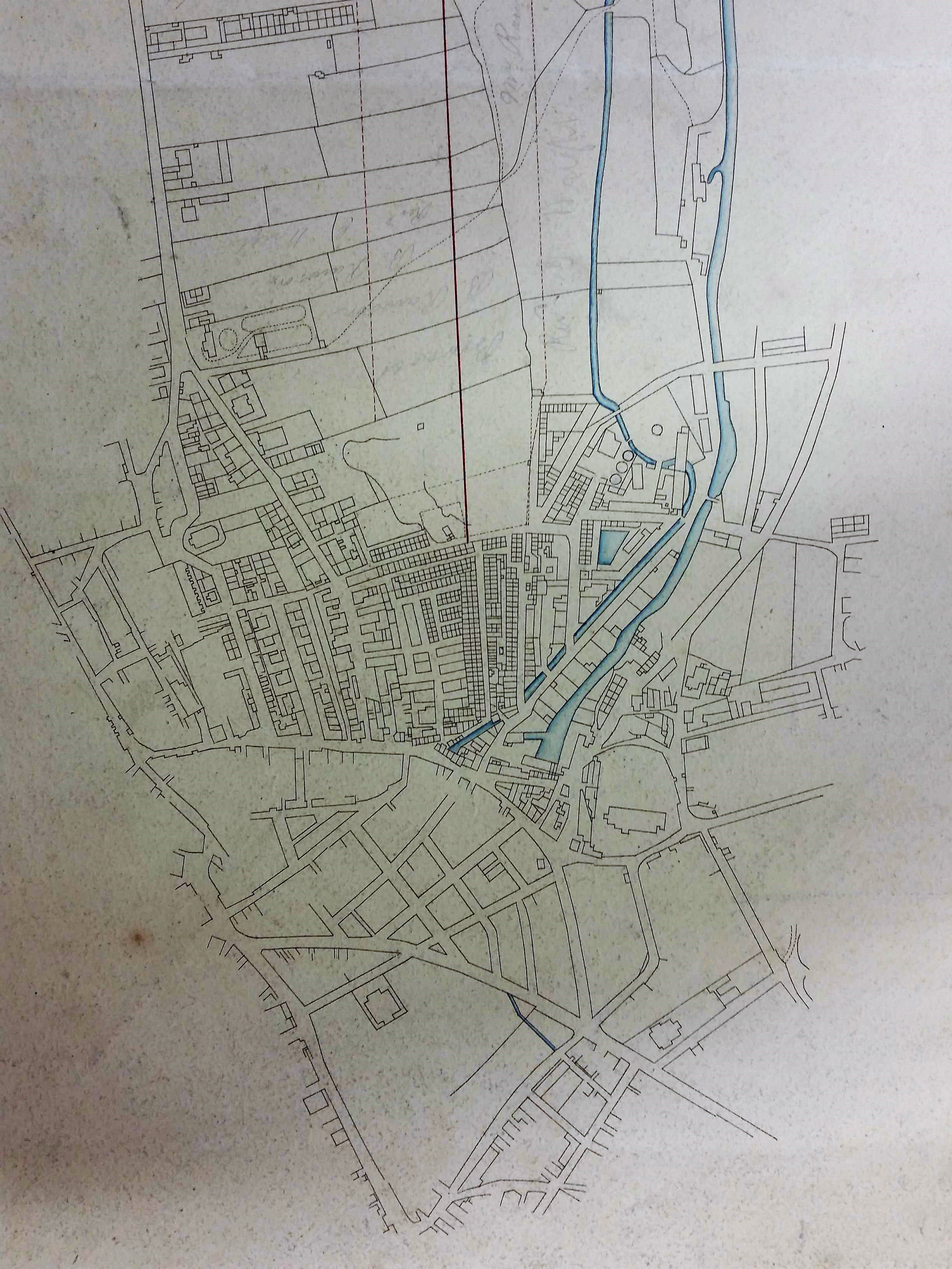
The Local Studies Library reserve collection has a number of maps showing early railway lines. I’m not expert in transport history, and in any case it is sometimes the non-rail aspect of the maps that interests me more. Firstly, we have an undated map (X30) showing the course of a Bradford-Leeds railway line. Fig 1 shows the Bradford end. The first thing to say is that this is not the course actually adopted for the first direct Bradford-Leeds railway, the terminus for which was Adolphus Street Station (approximately in position 10 on the map). Rather inconveniently, I should have thought, the planned line would have continued into Horton, passed south of St John’s Church (position 15), across Manchester Road, and presumably ended at a ‘Little Horton Lane’ station. What date is the map? The fact that the Old Courthouse is built, and the railway line from Halifax is not, immediately suggests 1834-1850. I’m sure that further study could make this calculation more precise.
The Local Studies Library has a letter indicating that Daniel and Titus Salt were interested in purchasing shares in some such development. The date of the letter looks like October 5 1830. I can confirm that items concerning ‘The Leeds & Bradford Railway’ was appearing in the Leeds Mercury in 1830 and that a Mr Walker was surveying a route. On October 9 of the same year Ellis Cunliffe Lister chaired a meeting of subscribers. This seems very early and was ultimately unsuccessful. A report about a possible Bradford to Manchester line 5 years later said that ‘an earlier speculation’ had failed. In the event the North Midland Railway only reached Leeds in 1840. The Leeds end of the map shown in Fig 1 does show the presence of other railway lines so that makes its earliest possible date somewhat later.
The map detail used for Fig 2 is also undated and unlabelled in any way. However, the red line must mark the course of another Leeds-Bradford railway. This line, in which George Hudson ‘the Railway King’ was closely involved, arrived via Shipley in 1846. To construct the line’s terminus Dunkirk Street was razed to the ground and on March 5 1846 the Bradford Observer noted the ‘deserted and desolate’ street. Within a few years Dunkirk Street Station was renamed Midland Station, and later Forster Square Station.

Fig 3 shows a detail of the first OS map: this was published in 1852 but the surveying must have commenced in the late 1840s. The Lancashire & Yorkshire line from Halifax is drawn which ended at Drake Street terminus (later Exchange Station). The second line moving off to the right went from Bowling junction to Leeds, via Laisterdyke, and was opened a few years later in 1854. It was operated by the same company and, I presume, allowed trains to travel from Leeds to Halifax direct, by-passing Bradford completely.
A ‘limestone quarry’ is mapped where the two lines divide. Limestone strata are deeply buried and do not reach the surface in the city area. Most limestone reached Bradford along the Leeds-Liverpool canal from quarries at Skipton, but there was nonetheless an early lime-burning industry based on the extraction of lime boulders from glacial moraines at Bingley. In this case the digging of a railway cutting presumably exposed further glacial deposits of the valuable mineral. Plausibly these boulders were taken to the nearby Bowling Iron Company where crushed lime was used as a flux in iron smelting. The ‘railway to Bowling Iron Works’ was a tramway or mineral line along which coal was transported. Note the number of coal pits surveyed.
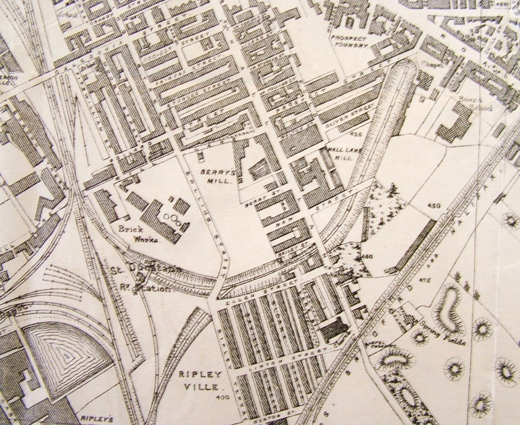
The detail used for Fig 4 is a generation later is from the 1887 Bradford map. All the railway lines are now in position. Note the brickworks near St Dunstan’s Station. This belonged to S Pearson & Son. Samuel Pearson was Cleckheaton brick-maker who founded a contracting dynasty. His largely forgotten works in Bradford, which he may have acquired from a William Poulter, was known as the Broomfield Clay works, later Sanitary Tube & Brick Works. In describing the work involved in taking the GNR railway line from the Exchange Station towards Leeds (1866) Horace Hird (Bradford in History, 1968) mentions the activities of Pearson & Son who took over responsibility for the material excavated from the cutting. They created a ‘great mound’ and for 15 years 60 men were employed making drainpipes, chimney pots and bricks from this collection. Their brick mark is [PEARSON & SON][BRADFORD]. The mark [P&S] is also a possibility, but if so it has a totally different shape of ‘frog’. Pearson’s brickyard was disused by the OS 1893 and Samuel Pearson had died in 1884 (worth £20,000) at the Elms, Scholes Road. The company was turned into an international contracting concern by his grandson Weetman Pearson (the first Lord Cowdray) and it undertook a considerable amount of work for the Mexican government.
