
10.073 BRA 1850 IBB
Size: 50*35 cm Material: paper
Date: 1850 Scale: 6.5 inches to 2miles
There are a number of copies of this map in the Local Studies Library. I think that the survey was originally undertaken by Thomas Dixon, and that a copy was attached to the Ibbetson 1850 Directory. The combination of this map, the directory, and the 1851 census returns provide a good picture of Bradford, a borough since 1847, in the mid-nineteenth century.
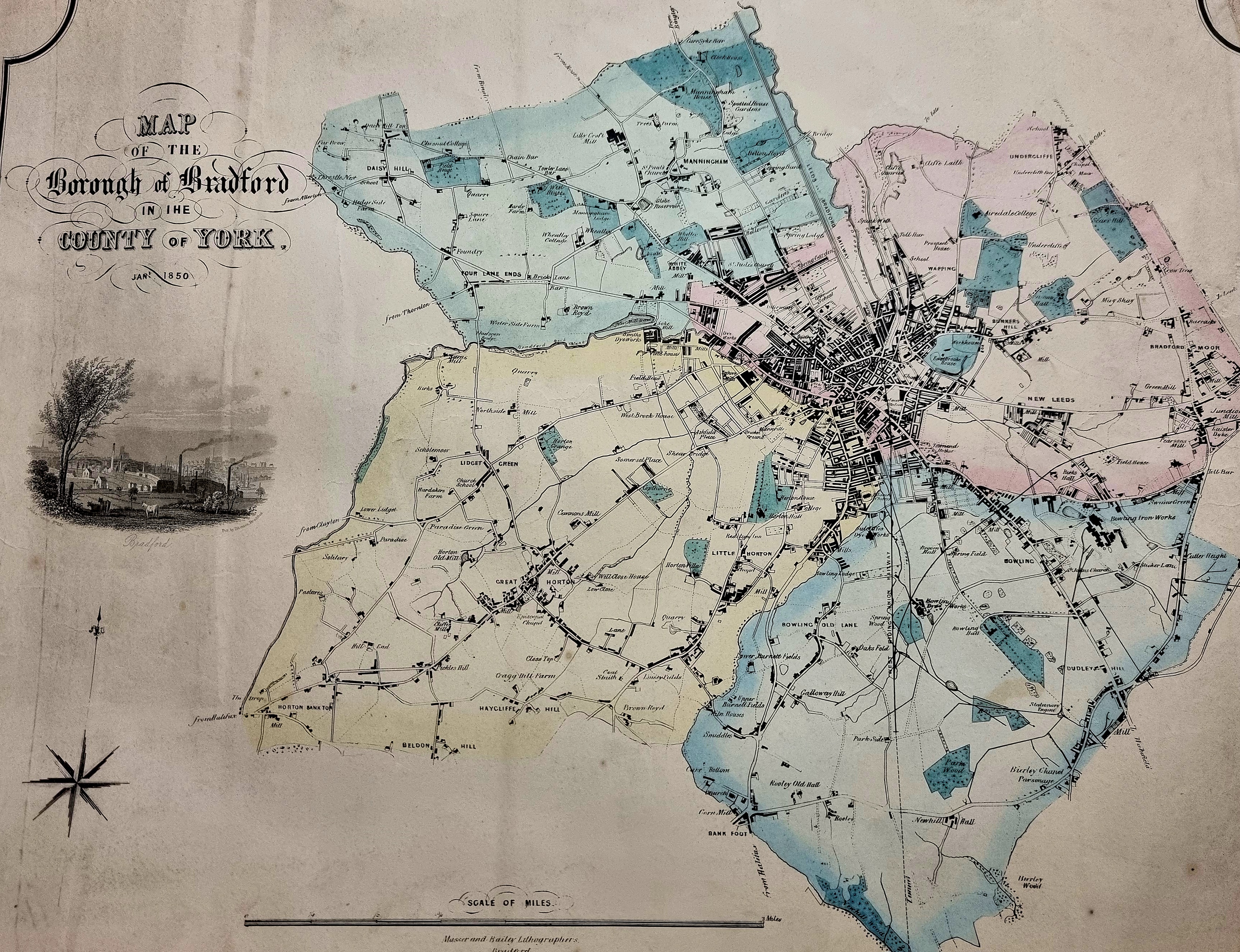
The entire map reveals how much of the modern city was essentially rural in 1850. I’m not sure of the significance of the blue and pink tinting. Sometimes it seems to designate individual estates but this is not universally true. Another possibility would be planned development areas. Both ‘mills’ and ‘houses’ are common. This is a town in transition. For a closer study of the map it is necessary to look at details.
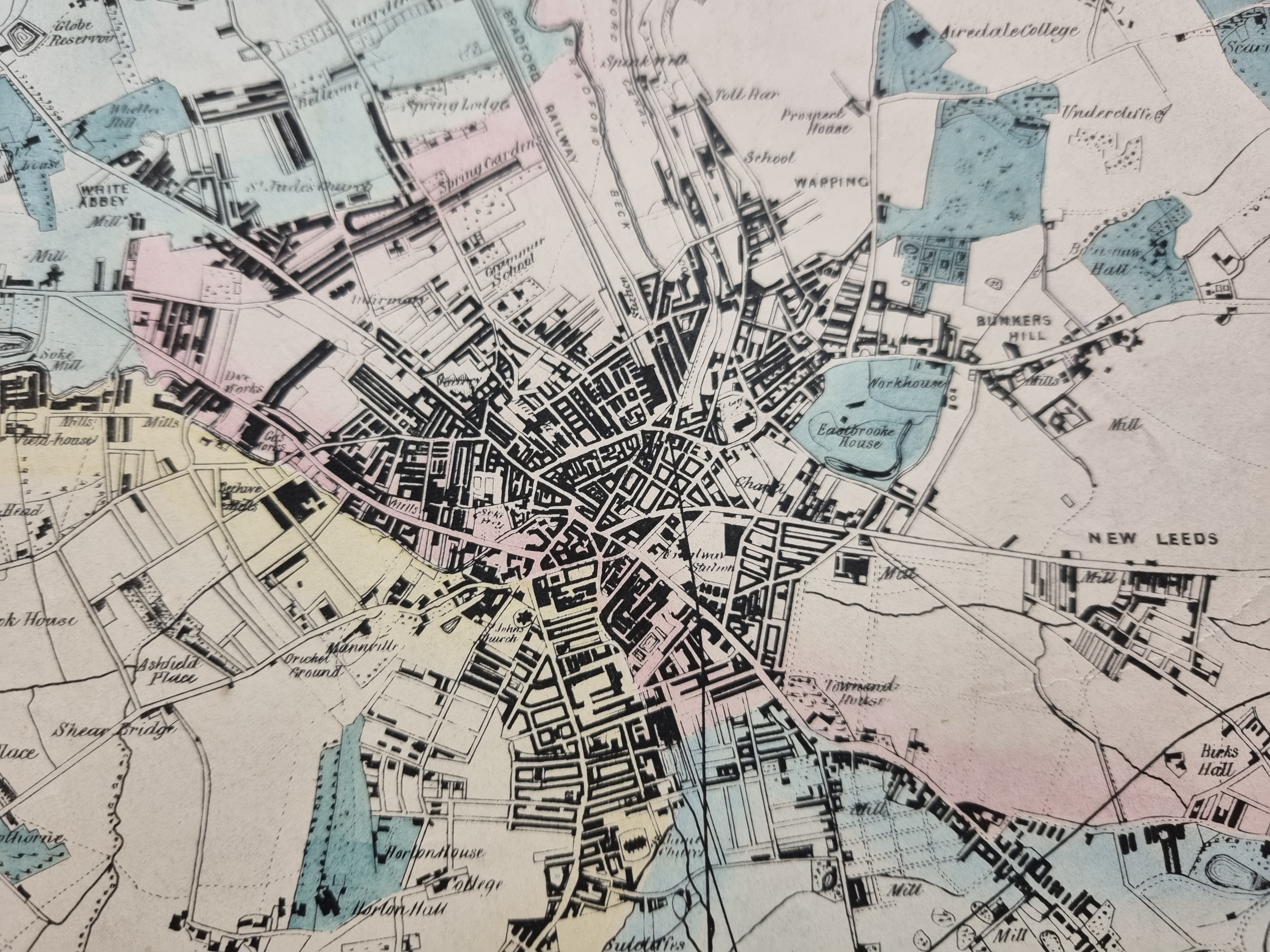
In this central section the canal and Bradford Beck show clearly. There is a direct rail connection from Leeds, via Shipley, to Dunkirk Street Station, and from Halifax to Drake Street Station. It would be another four years before the direct route to Leeds from Adolphus Street Station would be opened. All the main thoroughfares out of Bradford exist, Leeds Road and Thornton Road being the last to be constructed in the 1820s.
Starting at the top and working clockwise you should be able to identify: the school at Wapping, Airedale College where Congregationalist ministers were trained, Bunker’s Hill with its mill (but not seemingly its colliery) and the Barkerend Workhouse. Southwest of Leeds Road and the community of New Leeds a new street grid is planned. This is even more obvious southwest of Wakefield Road. In the same area note the ellipses containing small dots; these indicate areas of old mining activity. Due south is St James’s Church, constructed in the 1830s off Manchester Road. At 7 o’clock you can see Horton House and Horton Hall, but also a ‘college’. This was operated by the Northern Baptist Educational Society, but within 5 years they were to move to Rawdon.
Moving on you will be able to see Shearbridge and Ashfield Place but naturally not Bradford College and the University that now largely occupy the space. The Bradford Beck and Thornton Road are located around 9 o’clock. Two Soke Mills are visible which provides a delightfully medieval aspect, though I don’t imagine the Lords of the Manors are grinding much corn by now. Finally look for the old Infirmary site, the old Grammar School site and the church dedicated to St Jude, patron saint of lost causes.

The second detail centres on the Bowling Iron Works and St John’s Church, Wakefield Road, constructed in 1839. At 7 o’clock is Bowling (now Bolling) Hall and nearby the great Ripley’s dyeworks. Once again there is plenty of old mining activity. This would have been for coking coal and ironstone destined for the iron works. The network of continuous lines are tramways or mineral lines which moved the minerals extracted from pits to the works and to the coal staithe in Bradford itself. Very few signs of these now remain.
