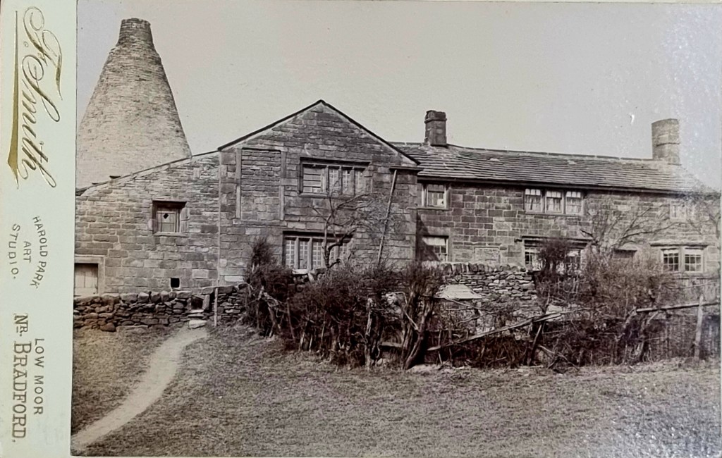
It is unusual to comment on a postcard rather than a map, but the Local Studies Library reserve collection has many treasures. This postcard is dated on the reverse, May 13th, 1899, and shows a farmhouse and ‘bottle’ kiln. The image is familiar to me since, some years ago, I studied it in West Yorkshire: A Noble Scene of Industry (p.40). In that useful publication it is simply described as a ‘bottle cone, Bierley’. Since it is used in a section describing brick and glass manufacture, I hoped that the kiln might represent the glass-making cone known to have been once erected on Wibsey Moor.

The second figure shows the appearance of the very well-reserved glass cone at Catcliffe, near Sheffield. I think you can see that my faulty identification was not totally fanciful. Subsequently it appeared that the Wibsey moor glass cone was probably demolished before the invention of photography.
I’m certain that the image used in A Noble Scene of Industry was the same one as I have shown, with the photographer’s details cropped off. Whether it was derived from this particular post card I cannot tell.

So, where was Lower Snake Hill Farm? It is quite obvious on the first Ordnance Survey Map (c.1854) south-east of Bierley Iron Works in the lower middle. The map shows a highly industrialised landscape with tramways, coal and iron pits, roads, and colliery engines. It is quite hard to envisage fields of waving barley waiting to be germinated and dried into malt, all ready for the brewer.

The second plan is a detail taken from the 25” OS map (1893) and shows the plan of the farm buildings about 5 years before the photograph was taken. Although the kiln appears to be circular on the photo this configuration was clearly not maintained down to ground level. There must have been a circular ‘chimney’ constructed over a square or rectangular drying kiln.
Attempting to match the ground plan with existing buildings, using Google Earth, I would estimate that Lower Snake Hill Farm still exists to the left of the M606 as you enter Bradford and between the motorway and Cleckheaton Road. If I can draw a parallel with Heaton then malting barley was an early to mid-18th century industry which was replaced by the more profitable coal-mining in the late 18th century. In south Bradford much of the coal would have been coked to provide the essential fuel for iron smelting.

With the expert assistance of Mary Twentyman of the Low Moor Local History Group I did eventually locate the Wibsey Moor glass works on the Fox map of Low Moor, and this did originally have a plan with a circular feature, consistent with a glass cone.
