4.054 BRA c1845 RAI BHM 446 B8
Material: cartridge paper Scale: unk
Size: 120*50 cm Condition: good
This whole plan is annotated ‘Leeds & Bradford Railway Valley Line through the Townships of Bradford, Manningham & Shipley’. It is essentially a very detailed plan of the Bradford Beck and the Bradford Canal spur north to Shipley.
The projected course of the railway line, which exists by the time of the first OS map (1852), is a completely straight red ink line as far as the outskirts of Shipley. Two straight red interrupted lines on either side may indicate adjacent land purchases to allow for construction and course variation. No hint is given of the purchases and demolition required to construct Dunkirk Street Station (later moved and remodelled it was known as the Midland Station and then Forster Square Station).
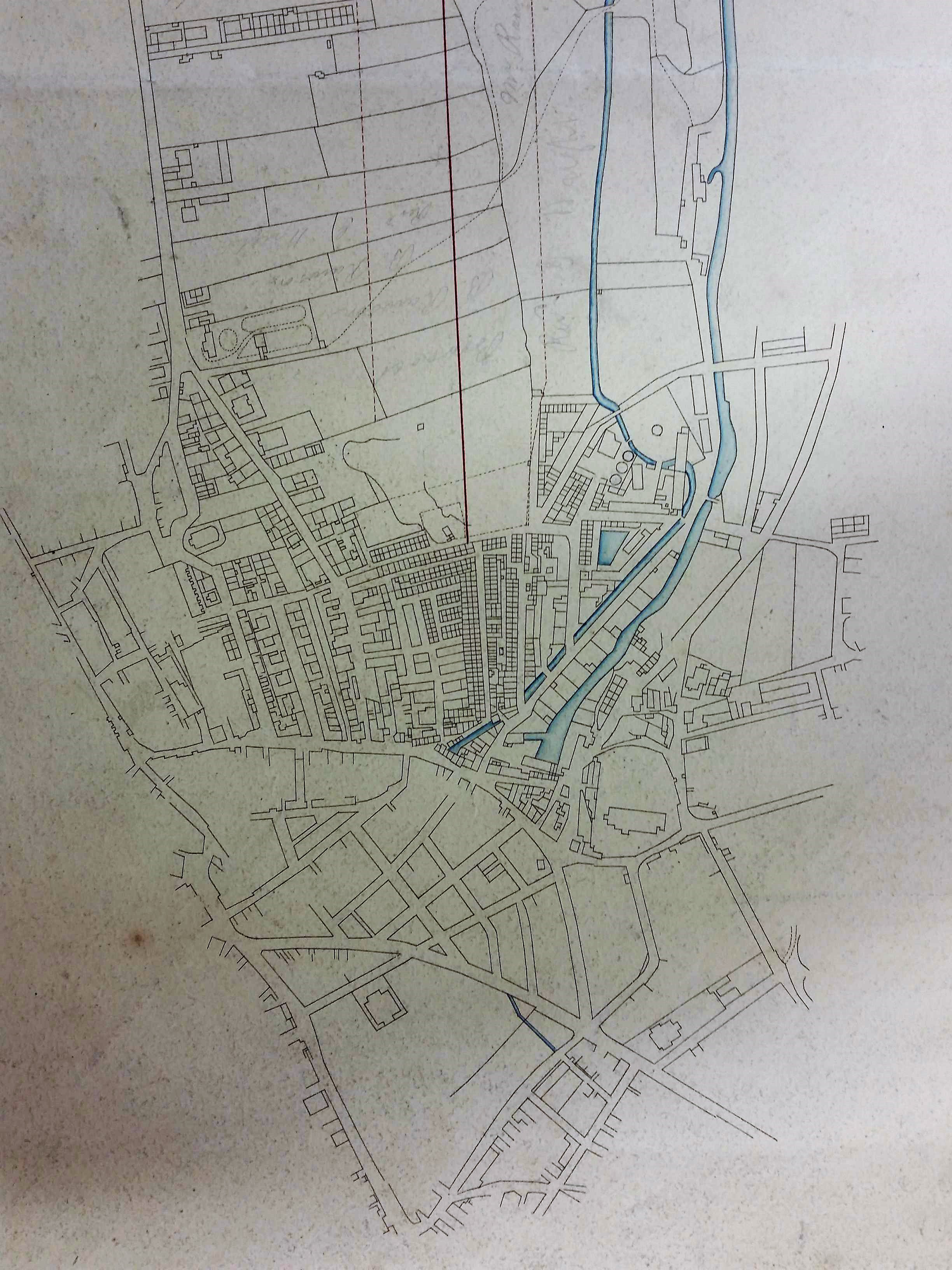
The figure represents a detail showing the Bradford section of the plan. It is beautifully drawn and tinted, but entirely unlabelled. The question is, can we identify the main buildings present and use them to confirm the plan’s date? The completed railway line was opened in July 1846 so the plan must be earlier, possibly several years earlier.
The blue tinted Bradford Beck and Canal are easy to identify. Where the Bradford Beck bends to the left are a collection of three circles. These must be the gas holders of the Bradford Gas Light Co. I must admit that I believed its Valley Road plant was constructed in 1852, so this is an anomaly I cannot yet explain.
Locate the canal basin and to the right is St Peter’s Parish Church (now Bradford Cathedral) with its churchyard. The cluster of buildings between the canal and the St Peter’s, surrounding the church steps, were swept away when the General Post Office was constructed in 1880.
Go to the bottom left hand corner of the churchyard: a short dog-leg brings you to Hall Ings. This is surrounded on both sides by a ‘gridiron’ pattern of streets: Swaine Street, Brook Street, Charles Street and Booth Street. These were created by the landowner Rev. Godfrey Wright in the 1830s. Hall Ings is then crossed by the ‘new’ Leeds Road. After that a building is drawn: this is the Old Court House which was constructed in 1834. A short distance further along Hall Ings is its junction with Bridge Street. St George’s Hall is not present, as expected since it would not be constructed until after 1850. But there were a cluster of buildings at this point already which were not drawn, presumably because they were too remote and too unimportant for the surveyor’s purpose.
Go back to St Peter’s and this time move due south a short distance. This area was, after 1860, filled by the merchant’s warehouses which make up Little Germany. Well Street and Vicar Lane make the appearance of a capital D. This area was once known as Colliers Close and was also owned and sold by Godfrey Wright. Adjacent to the junction of Leeds Road and Vicar Lane is the Methodist Eastbrook Chapel, later Eastbrook Hall. The first Mechanics Institute was already in existence nearby, but is not drawn.
Go to the top left of the map: the street entering Bradford is Manningham Lane. At the old Bradford Grammar School it divides into Manor Row and North Parade. The fields between Manningham Lane and the projected line have the names of landowners written in, in pencil. This makes perfect sense if some of their land is to be purchased.
In Manor Row the third building is the well-known Salem Chapel, which still exists. The building by the kink in North Parade is the Anglican Christ Church. Constructed in 1815 this is long demolished, having fallen victim to one of the city’s many road remodelling schemes.
Running a few degrees east of due south of Christ Church is Darley Street. Follow Darley Street down to its junction with Kirkgate. As you can see the buildings north of Kirkgate are drawn in great detail, but south of Kirkgate things are very sketchy. I think we can be quite confident that the plan is 1835-1845 in date. So now we need a volunteer to match the houses north of Kirkgate with the 1841 census returns!
