
3.004 BRA c1825 PLA BHM 2033 B29.
Paper backed with linen Scale: unk
Size: 50 * 40 cm Condition: fair
This plan was originally used, several years ago, as my Local Studies Library ‘map of the week’. It also featured in this series a few weeks ago under the title: ‘East and south Bradford in the early nineteenth century’. It is a great personal favourite: I find that I keep coming back to it, trying to better understand its date and purpose, neither of which are indicated on the map itself. A newer phone camera means that the standard of reproduction is better, and after a long Covid break I’ve been able to re-examine the plan itself and not simply photographs. On this occasion, I shall correct one or two errors that I made. earlier I believe I can reasonably attempt a complete analysis of the plan and provide as much explanation as possible.
We are looking at Bradford as it was two centuries ago. There is an annotation on the back of the plan reading ‘Bowling Hall Museum’ so we know from where it reached the LSL, probably in the 1960s. Other than this there is no provenance. It is a hand-drawn plan in sepia, with some annotations in a different ink, and also in pencil. It shows the east end of Bradford, with Wakefield Road and a collection of ‘new roads’.
I have spent a good deal of time in the last few months looking at the eatates of‘ the Rev.Godfrey Wright in Bradford. Although his name does not appear on the plan, I have no doubt it is his property that is recorded here. The map is evidence of the very considerable quantity of land that Godfrey Wright possessed in south and east of the town. The absence of his name would seem to rule out any official use for the plan – such as litigation or land sale. My guess is that the plan was originally used by his local agents, the owner himself spending his life in cultivated ease at Bilham House, Hooton Pagnell. The plan may have once accompanied a rent book, or similar record, which has now become detached. We do have another of his estate maps which actually lists the properties in numerical order. The areas of the closes list do correspond with this plan and his property in Bradford alone (excluding Horton and Manningham) makes up more than 180 acres. Not for nothing has Godfrey Wright been called Bradford’s biggest landowner.
Undertakings made when the property was bequeathed to him suggests that 1815 was the earliest date by which Wright could be considered its owner absolutely, but it originated as a bequest from Charles Swain Booth Sharp of Horton Hall in 1805. Sharp in turn was left a large property by a relative, Elizabeth Swaine, in 1759. She was known to have lived in Hall Ings, possibly with her unmarried sister Mary Swaine. It is perfectly plausible that she owned land in the surrounding area and her house may actually be drawn here. It follows that overall, the plan may to some extent reflect her situation in the mid-eighteenth century, although there will have been some changes, like the creation of ‘new roads’.
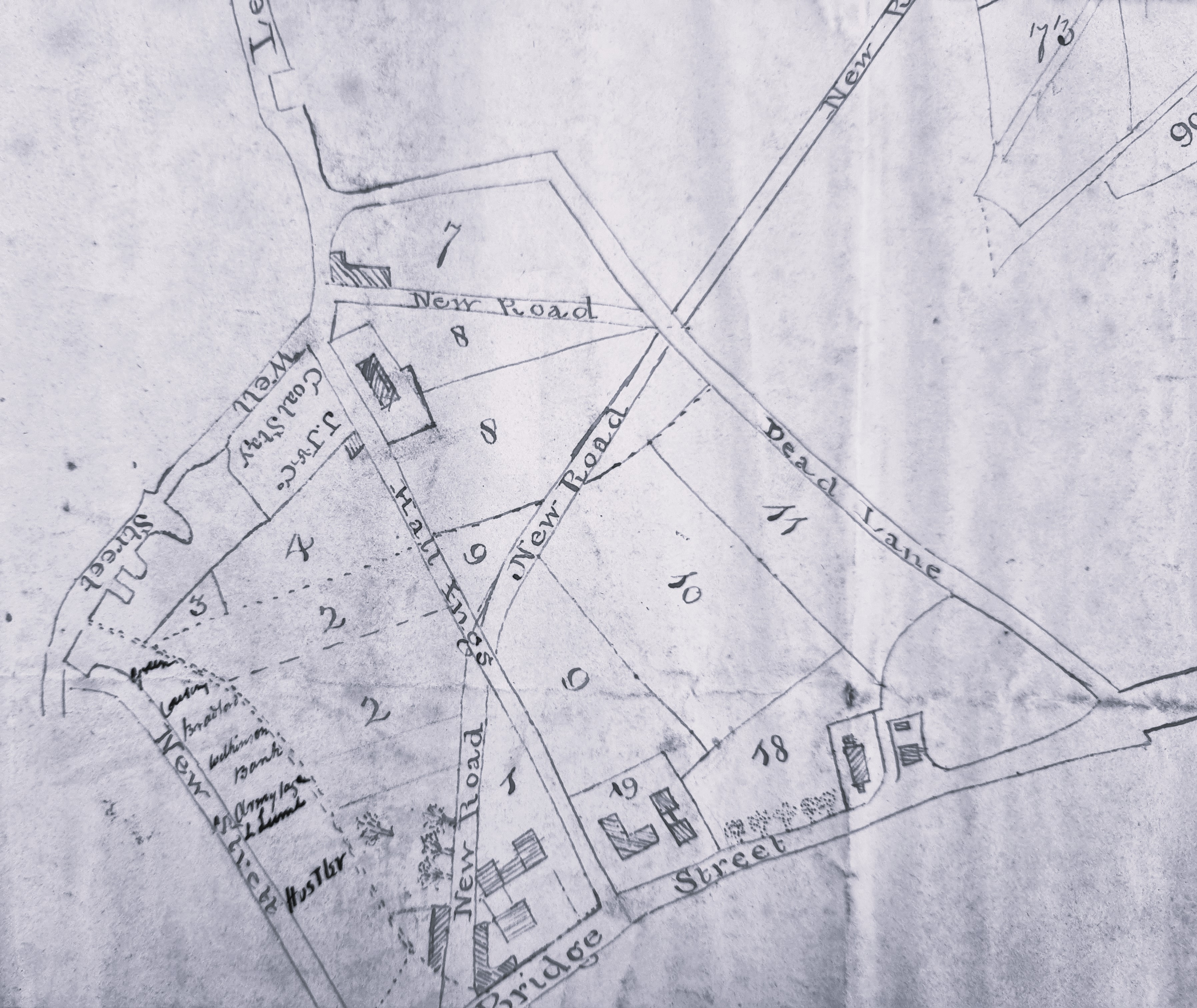
The first figure shows the whole plan, but individual details will be much easier to study. The first of these details shows the town end of the plan. Vicar Lane is here known by its old designation of ‘Dead Lane’. The ‘New Road’ which, together with a portion of Church Bank, encloses plot 7 retains this name in some old Bradford maps, but forms part of Leeds Road and Well Street in others. We know from other map evidence that plot 7 was known as Colliers Close. There is nothing implausible about it being the site of eighteenth-century coal mining. Other evidence suggests that Godfrey Wright sold this land some time after 1847 and twenty years later it became the site of Little Germany.
It is not difficult to locate Hall Ings running from Well Street to Bridge Street. It is crossed by ‘New Road’ making an ‘X’ shape. The New Road then continues to cross Dead Lane. I previously hypothesised that the two unconvincingly drawn junctions indicate the original plan did not include the New Road, even if it was subsequently added by the same hand using the same ink. The New Road is very definitely not on the 1802 Bradford map. However the house surrounded by plot 8 is on the 1802 map enclosed by a garden. I take this to be the house of Elizabeth Swain herself, but in her day, and indeed in 1802, the house didn’t afford a picturesque view of a coal yard!
In fact, two coal staithes are drawn on the map. A staithe is a place adjacent to a highway from which merchants can collect a supply for subsequent delivery to their customers. The one visible in this detail (and called a stay) at the junction of Well Street and Hall Ings, is marked ‘J J & Co’ which must represent John Jarratt of the Low Moor Iron Company. How was this supplied with coal stocks? Horse drawn wagons is one way. Another possibility is that John Jarratt, although an early Low Moor partner, may have had interests in other coal mines whose product could reach this area via the nearby Bradford canal wharf.
It is clear that Bridge Street, and Hall Ings are in their present positions, and Leeds Old Road is now Barkerend Road. As far as I can tell the numbered areas represent individual fields or ‘closes’ of land. Trees are growing west of the first section of Leeds Road and a rather larger wood is mapped there in the 1802 Bradford plan. At the opposite end of Wells Street is another ‘new street’ which had been in existence for some years and has evolved into Market Street. Behind this is a rather sketchily drawn Bradford Beck.
A subsequent user of the map was evidently interested in the owners of property between Market Street and the Beck and has added some names. You probably won’t be able to read these names, and in fact they were still not easily legible even on the original map. As far as I can make out, reading from top to bottom, the names are: Green, Cowling or Crossley, Bradford, Wilkinson, Bank, Armytage, L Lumb, and Hustler. There are directories listing Bradford business in 1822 and 1834. Plausible identification of most of these names in Market Street can be made from these directories although it is impossible to be quite certain.
Thomas Green, grocer and tea dealer 1834
David Crossley, attorney 1834
Bradford – uncertain
James Wilkinson, cabinet maker 1822
Thomas Jowett Wilkinson, cabinet maker 1834
Bradford Commercial Bank Co. 1834
Samuel Armitage, plumber & glazier 1834
John Lumb, straw hat maker 1822
Ann Lumb, pawn broker 1822
Thomas Lumb, pawn broker 1834
The name Hustler is more difficult. The famous Quaker wool-stapler and canal promoter, John Hustler, had died in 1790. I believe he left two daughters. The fact that Market Street boasted two wool-stapler partnerships carrying his surname cannot, surely, be a coincidence. The two partnerships were Hustler & Blackburn and Hustler & Seebohm, and I have confirmed the existence of both in other sources.
I can identify some other features. The buildings in area 19 are also present on the 1802 map, but must have been knocked down in 1850 when St George’s Hall was erected on land Godfrey Wright sold for £15,000. He also owned site 9 on which there were no existing buildings. In 1834 the old Court House would be constructed here, but the Hall Ings frontage of this site is now occupied by the Bradford T&A building. The formal entrance to the neoclassical Court House building was from Hall Ings. In the angle between Hall Ings and Wells Street (plots 2. 3 and 4) Godfrey Wright undertook a large development. In 1836 he sold 647 square yards around the newly developed Swaine Street for a construction which remained the headquarters of the Bradford Commissioners, and their successors Bradford Council, until the Town Hall was built in 1873. Charles Street and Booth Street were laid out at the same time. Later, in 1845, Godfrey Wright sold 620 square yards of land at the bottom of Leeds Rd and Charles Street to the West Riding Union Railway for £920.

In the second detail the ‘New Road’ is Leeds Road. There is a second coal staithe; ‘JS & Co’ must surely be Jno. Sturges one of the Bowling Iron Company partners whose company presumably supplied this Eastbrook coal staithe. The ‘new railroad’ which is drawn is in fact a mineral carrying tramway bringing coal in trucks to the Eastbrook staithe from the iron works, by rope haulage. The tramway cuts across a great deal of Godfrey Wright’s land and it is reasonable to assume he was paid rent and ‘wayleave’, and didn’t afford this privilege simply from the goodness of his heart. Bowling Iron Company owned and operated many collieries and ironstone mines. The tramway itself was closed in 1846 and the area is marked as an ‘old staithe’ in the first OS map of the area.

Back Lane, leading off Wakefield Road, is today called Bowling Back Lane. The buildings drawn here probably represent Birks Hall. They are numbered 150, but in the list of his properties I mentioned earlier this is simply recorded unhelpfully as ‘house’. Godfrey Wright certainly owned all this land, which was known as the Field House Estate, and he had coal and ironstone mining interests here. I’m not sure why all the fields in this area are named as well as numbered but the names are of interest. So, 151 is Birks Field, 154 is Pease Close and 150 includes Rushey Bottom. Rushes are not a feature you associate with Bradford today, nor are Peas for that matter.
Through the fields to the right and roughly parallel to New Road (Leeds Road) are two lines drawn in pencil. They should be faintly visible even in the photograph, but are very clear on the original map. I wondered about the Bradford-Leeds railway line but the position isn’t correct. In fact, both Wright estate maps in the LSL Reserve Collection have pencil lines indicating rail and road development, some of which clearly never took place. They remain as evidence that these were working plans and need not represent the exact situation at any individual year. Naturally there is no indication of the railway track which within a generation bisected the space between Bowling Back Lane and Leeds Road.
