
This map is in the permanent collection of the Bradford Local Studies Library, and is catalogued as BRA 1722 BRA (reprint). The original was part of the Hailstone Bequest to the Dean and Chapter of York Minster but is apparently now missing. Copies have clearly been made and one was kindly brought to my attention by a Saltaire Collection volunteer, Jo Singh. Doubts have been expressed as to the authenticity of the original, but my own feeling is that, within certain limitations, it is as reliable as any other contemporary plan: not that there are many of those. The Bradford & Horton map was unpublished until it appeared in a 1931 edition of The Bradford Antiquary (Vol.7), written by its then editor, J Hambley Rowe. It is clear that Rowe accepted the map as genuine, and he spent a great deal of his article matching places mentioned in 1722 with those he recognised in Horton two centuries later.
However, after 40 years, John S Roberts published an article in the Bradford T&A (21 August 1971) entitled ‘Who faked a map of Old Bradford?’. Roberts has appeared in these pages before because in 1977 he produced an invaluable short pamphlet entitled Little Germany, which was my personal introduction to the history and architecture of that area. He was evidently a knowledgeable and thoughtful man whose opinion cannot easily be set aside. He explained he had four tests for accepting a map as authentic:
1.Knowledge of the reason for a map being created.
2.The name of the surveyor or cartographer.
3.The map clearly matching the standards of its day.
4.Corroborating evidence from other sources.
Roberts had also noticed various anachronisms on the map, and on all these grounds he concluded that the map failed his tests. He knew that Samuel Hailstone (and his son Edward) were enthusiastic collectors of local plans and documents, and he evidently felt that they had been conned into buying a spurious example for their archive.
The final historian to examine this whole issue was the late Kath Alred (The Bradford Antiquary, 3rd Series No 11 (2007) pps. 5-10). In her article she began by noting how useful the map was, but she reported that she had been told by unnamed local historians that it was a fake. On the other hand, she felt that Samuel Hailstone was an astute solicitor who was unlikely to have been very easy to hoodwink with a fraud.
Alred noted that it was in the eighteenth century that property maps were being introduced, and Hailstone would have known many of the important Horton families personally. She even speculated that he might have himself collected the information on which the map was based. She consulted all the other plans of Horton and Bradford she could find. Although little data was strictly comparable with the 1722 plan, where such material existed, and could be compared, it did match. Similarly, she read William Cudworth’s Rambles Round Horton and found a degree of correspondence. She pointed out that the whole plan was not all drawn at the same time – the writing style sometimes varied – but in short she was convinced that the plan was not a fake but rather a sketch based on oral history, with some areas being represented more exactly and precisely than others.
Can I add anything? If you have looked at several of the reserve collection maps that I have put online, you will know that very frequently they have no clearly defined purpose and no recorded surveyor. It is quite likely that over time they have become separated from documents that would have provided provenance. Some of the plans of Rev. Godfrey Wright’s estates contain anachronisms (like railway tracks) since additions continued to be made for decades after the initial survey. Alternatively, ‘new’ maps have not always followed a new survey but simply a re-drawing of an old survey with additions. The 1722 plan does not appear unusual in this respect.
Alred commented that the boundaries of many fields on the Horton map are formalised, looking rather like a brick wall. But other fields at a place called Howcloughs are much more plausibly drawn and have letters defining them; were they under specific consideration? A table at the bottom of the map is headed ‘Def’ts Farme in Question’ and has the name of the listed fields. If that odd word is a contraction of ‘defendant’ then this hints at a legal document.
In my opinion her views are confirmed by an early plan of Heaton which I know well. It is also likely to be of eighteenth century date, and also came to York Minster Archive as part of the Hailstone bequest. This plan centres on the hamlet of Heaton Royds which is, as far as I can tell, accurately drawn and labelled. A contraction of the word ‘defendant’ also appears, again suggesting legal involvement. But it is evident that the main roadways, and the township of Heaton itself, are included with no attempt at accuracy – exactly like the field boundaries of Horton.
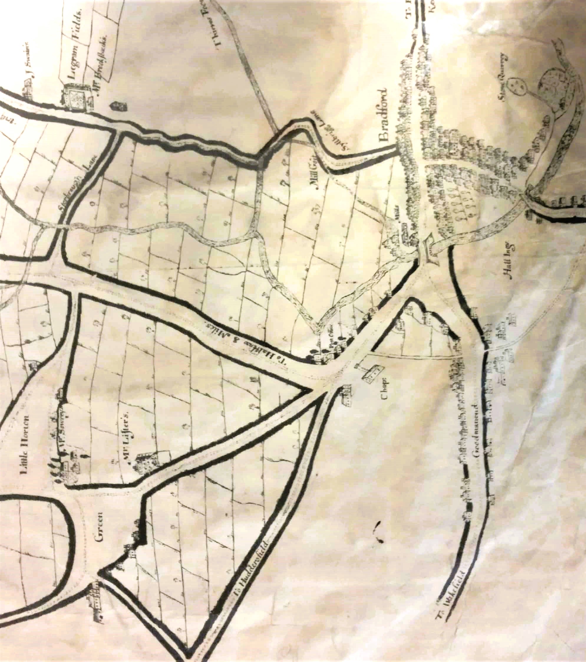
I don’t know modern Horton well enough to comment on the features from 1722, but I think I can make an attempt with the small section of the plan that includes Bradford itself. I’ve been trying to compare this map with the Bradford map of 1802. Rotating the 1722 map by 90 degrees anticlockwise brings them to approximately the same alignment. Both show and label Goodmansend (modern Bridge Street). This road is lined with houses. Leaving this road and joining the Leeds Old Road is a path which could be an embryo Dead Lane or Hall Ings, probably the latter. This and the two principle roads, and a segment of the Bradford Beck, isolates an area itself called Hall Ings. On the opposite side of Goodsmanend is the unlabelled Chapel Lane, with a label ‘chapel’. This forms a base of a triangle, the other sides of which are The Bowling Green and the Turls. These wide roads unite at the bridge by the Sun Inn to form Ivegate.
Ivegate is lined with houses, but my assumption is that these are included as a way of expressing urbanisation, rather than being an accurate portrayal of individual properties. Ivegate is marked ‘Bingley and Keighley’, which works as Ivegate becomes Westgate. Leading west off Ivegate is Kirkgate. The canal basin doesn’t exist yet, and the Parish Church doesn’t seem to be drawn. The stone quarry is a puzzle which I find hard to place on the ground. There is no sign of it in 1802, Well, at least you reach it up a tree-lined path! Elsewhere on the plan is the comment ‘pits now working’ which is perfectly plausible almost anywhere in the Bradford area at this date.
I struggle with some of the other roads. In 1722 both Leeds Road and Thornton Road were a century in the future. Sterbrough Lane is labelled; is this Shearbridge Road joining what is now Listerhills Road and Syllbrigg Lane which ascends to Westgate? The mill goit is obvious and accurately drawn I believe. It should end at the Bradford manor soke mill, but the plural ‘mills’ is clearly written. Was there once more than one mill? Bradford Beck seems to be called Thieves Foor Beck: Rowe records that there was a Thieves Score bridge at bottom of Cemetery Road. The most potentially datable building on the map would seem to be the chapel in Chapel Lane. Historian John James gave 1717 as the construction, but he found evidence for an earlier Presbyterian chapel, also on Chapel Lane. Either way the 1722 plan could well be correct as to its position.
I knew Kath Alred when she was working on the history of Heaton, and I admired her work greatly. I would certainly be inclined myself to accept her considered view on the authenticity of the Bradford & Horton plan.
