2.157 BOW c1848 PLA
Material: tracing paper Scale: unk
Size: 55*32 cm Condition: poor
We are in essentially the same area of Bradford that was visited in the last map I posted. About 4 years ago in 2018 this plan was used as a ‘map of the week’. As you can see it is not one of the highest quality of productions. It looks like a copy produced by someone showing a good penmanship standard, but who was not a professional mapmaker.
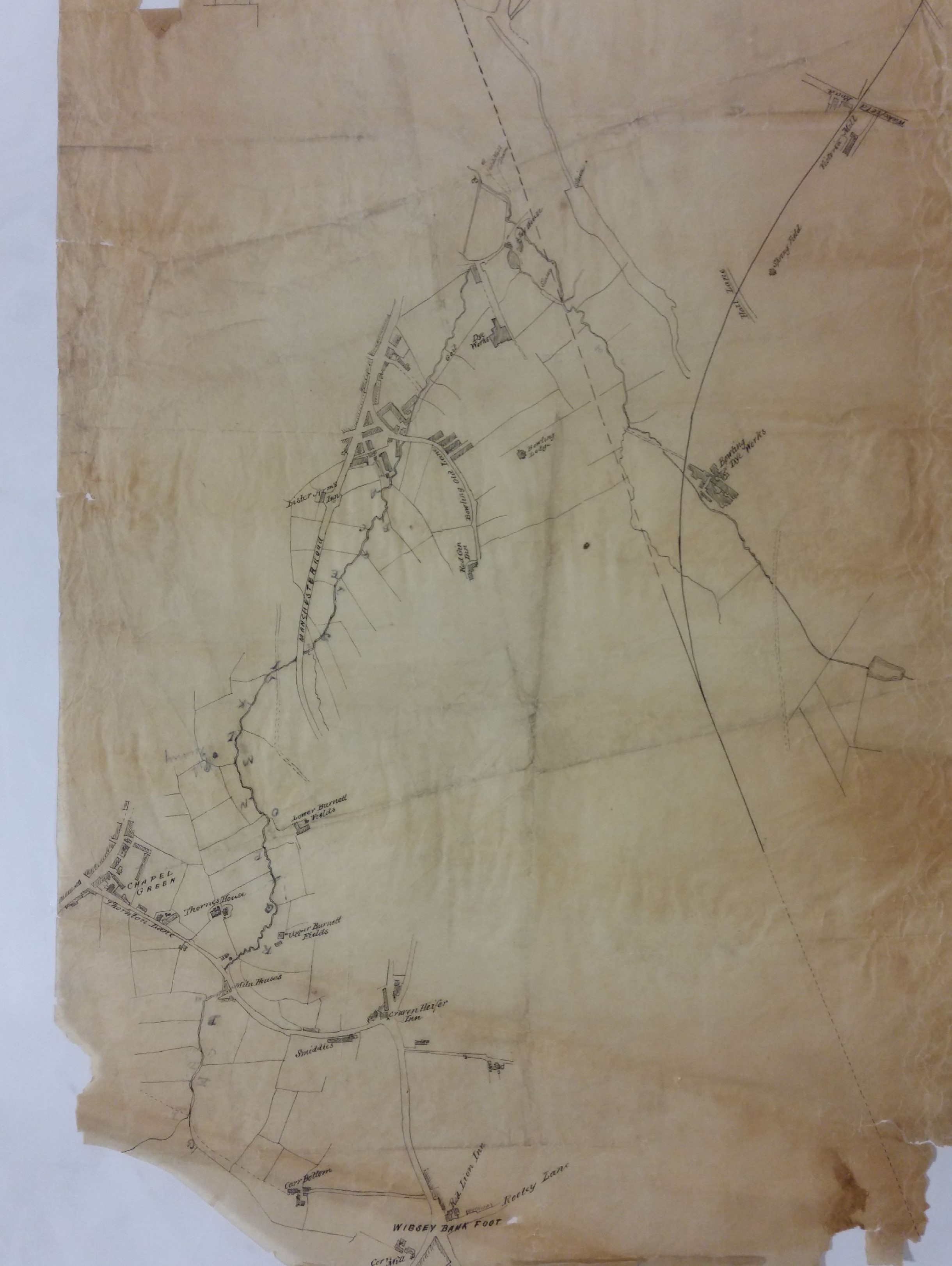
As so often the plan is undated. No indication either is given concerning the plan’s function, but a useful clue is provided by pencil letters A-R along the course of Low Beck until it reaches Thornton Lane in Chapel Green. Thereafter there is a second sequence of numbers A-G. The words ‘pit quarry’ appear adjacent to L and M, although no pit or old pit is present at this site in the first Ordnance Survey map of the area (1852). The original mapmaker was not at all interested in the extraction industries. In reality the whole area would have been covered by both working and disused collieries and quarries, as the first OS map of the area illustrates. The lower part of the map would also have been crossed and re-crossed by mineral ways supplying Bowling Iron Works with iron ore and coking coal.
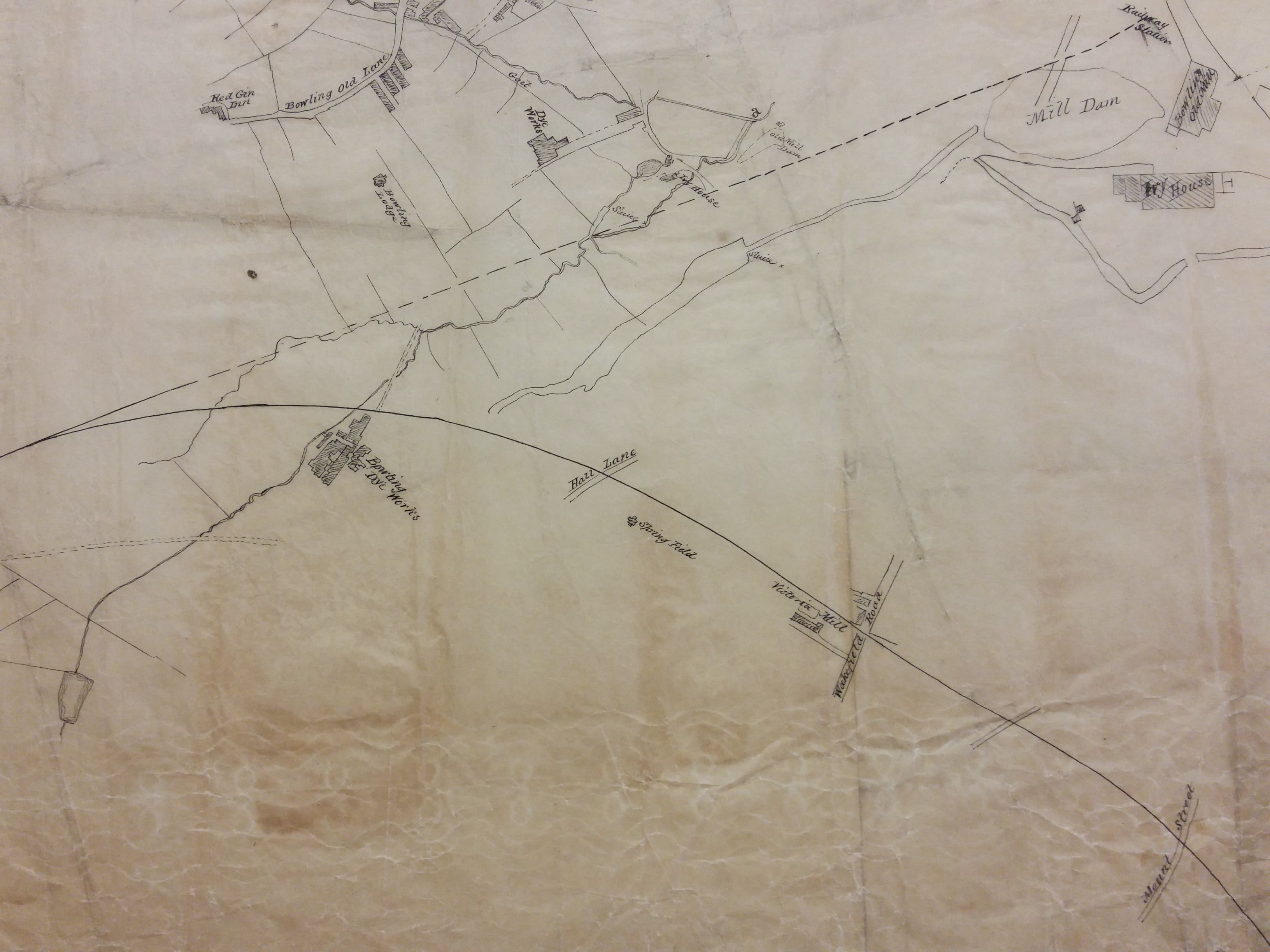
The overall arrangement of buildings closely resembles the 1849 borough map. It is odd that St James’s Church (constructed 1838) is not drawn: could the original map have pre-dated this? The most prominent features are watercourses. I’m ashamed to say that until I started studying old maps I used to talk vaguely about ‘tributaries of the Bradford Beck’, but all such branches once had individual names. The Bradford Beck proper flows into the city to the south of Thornton Road. Out of sight in culverts it turns almost 90 degrees and flows out towards Shipley, roughly parallel to the canal, to meet the River Aire. Its main tributary, the West Brook (formed from the junction of Horton Beck and Shear Beck) is still visible flowing in front of the old Phoenix Building at the University, and joins the Bradford Beck near the site of the old Beehive Worsted Mills, Thornton Road. Neither of these watercourses are mapped here. What you can see are the Law (or Low) Beck the last section of which has been straightened and possibly culverted. It joins the Bowling Beck above Bowling Old Mill at a point marked ‘a’. Goits, dams and sluices are also mapped.
Determining the map’s exact date is quite difficult. The overall arrangement of buildings closely resembles the 1849 borough map. A straight but interrupted line marks the course of the Lancashire and Yorkshire Railway into Drake Street (Exchange) Station after 1850, although the station itself is not mapped. The curved track from Bowling Junction to Laisterdyke is represented by a continuous line. This track, constructed in 1854, enabled Halifax to Leeds trains to avoid delays caused by entering and reversing out of Bradford. I assume that, since none of the stations or junctions are named, the lines were added after the map was first drawn or perhaps when it was copied from an older original. I cannot say why the Adolphus Street station to Leeds line, also opened in 1854, was not included.
It is interesting to note that although south Bradford is largely rural both Bowling Dye Works and Bowling New Dye Works are present. Soft Yorkshire water was found to be very satisfactory for dyeing. Bowling Dye Works had been built at Spring Wood in 1822 but the business had been founded much earlier by the grandfather of a Bradford immortal, Sir Henry William Ripley (1813-1881). What is missing on this map is its huge reservoir and several dye pits which are clearly present on the first OS map. I’m not sure exactly when the New Dye Works was constructed but it was certainly in existence by 1849. Between the two works you can see Bowling Lodge, built for Sir Henry William Ripley in 1836. But, as a builder, Ripley is most famous for his creation of a model village, Ripleyville, beginning after 1866 and continuing until his death. This included terraced housing and alms-houses. Strictly speaking Ripleyville was Bradford’s only industrial village since Saltaire was constructed in the then independent township of Shipley. Everything was demolished and redeveloped in the 1970s.
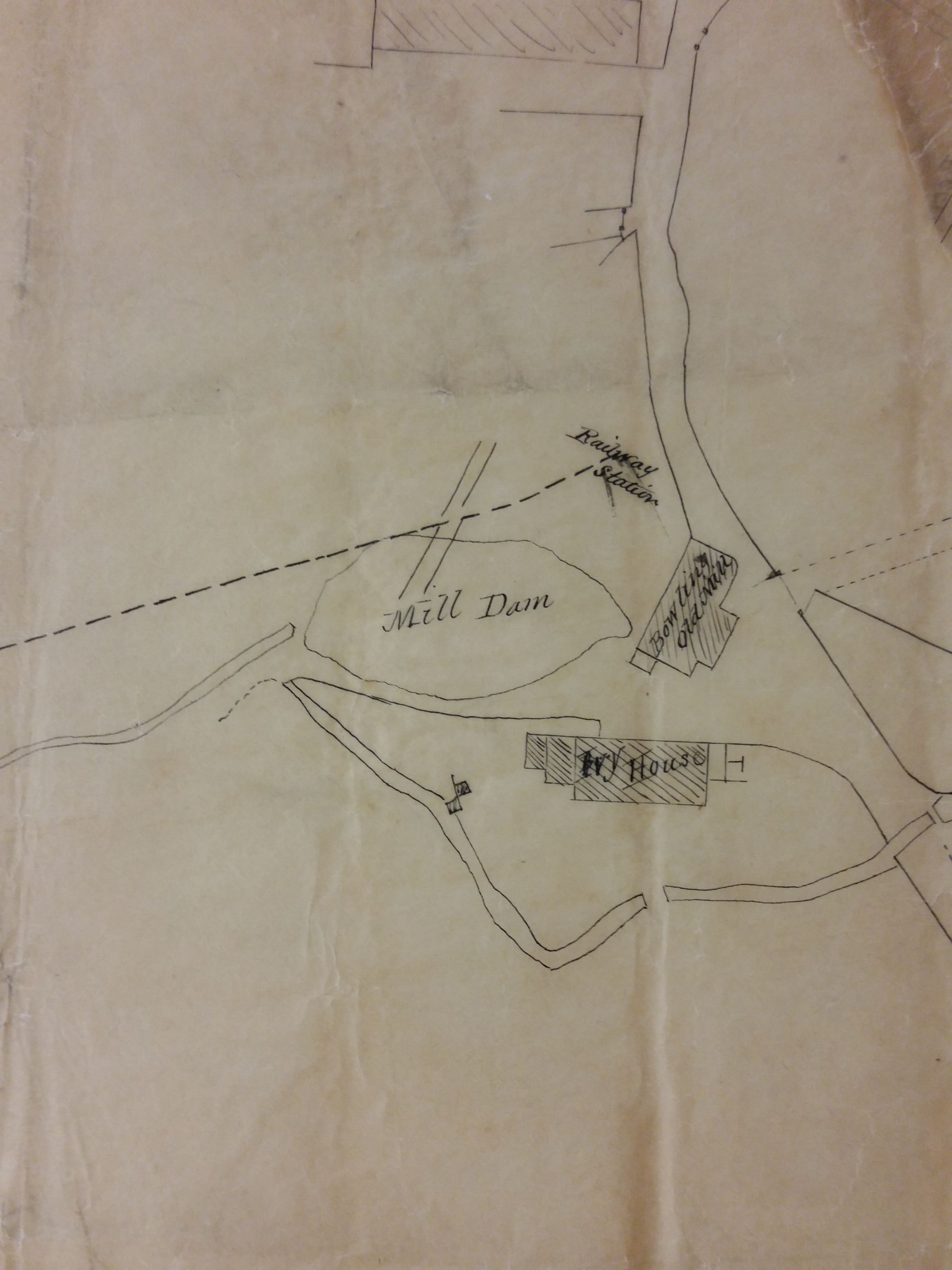
Rather confusingly in the ‘V’ formed by the two railway lines is drawn what appears to be a large artificial lake and sluice. This is simply an enlargement of the same feature drawn, at a much smaller scale elsewhere. The watercourse ends at a Mill Dam overlooked by Ivy House and Bowling Old Mill. A body of water existed in Bowling Mill Field as early as 1839 because a little boy was reported drowned in it. It stood in a field called Mill Holme. The corn mill itself was certainly present a century earlier than this map when the miller was one Reuben Holmes. The mill may have had a much earlier foundation still, associated with the Manor of Bowling. Cudworth records that a walk along Bowling Beck was notable for rabbits and partridges. Possibly trout too, which will interest one of my regular map correspondents who is noted for game fishing. To draw the water supply to Bowling corn mill twice must indicates its importance to the maker of this map. Could this have arisen from a notorious legal case around this time? Henry Ripley had some highly controversial plans concerning south Bradford’s water supply which he had come to dominate in the area below Bowling Dye Works.
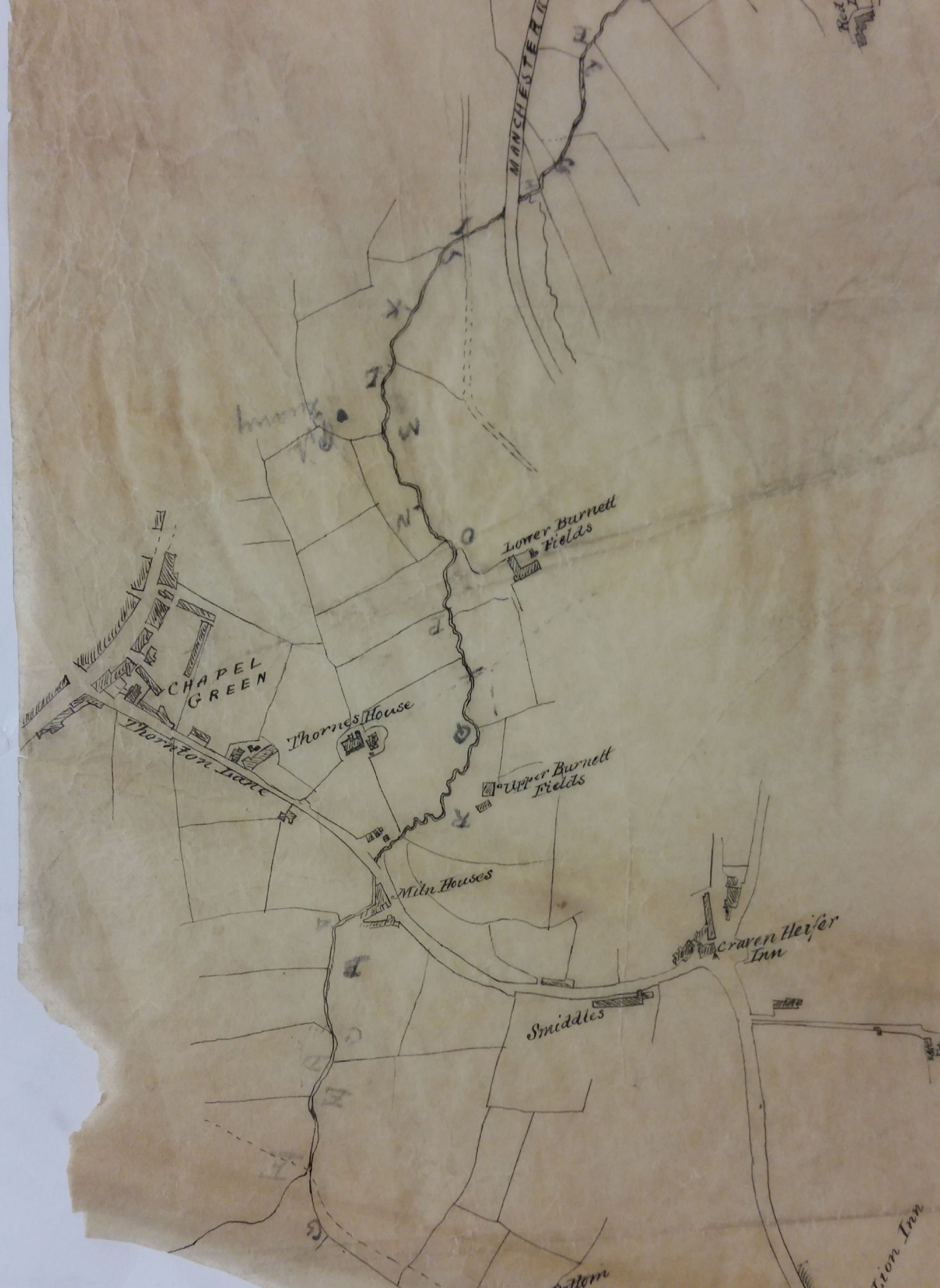
I don’t know much about Ivy House, but in the 1840s it was the home of John and Elizabeth Cheesebrough with their children, who are there at the time of the 1841 census. John was a woolstapler who died in 1850. One of more of his sons remained in the textile trade. The railway station marked on the plan must be St Dunstans I assume, but this was constructed much later in the 1870s. One of the many features of this map which are hard to explain.
