
Including the initial ‘map of the week’ series, over 200 maps displaying Bradford’s history have been put on-line. Inevitably some will appear more than once, and various combinations of the information they contain will be discussed. Most are from the Local Studies Library reserve collection, but I have other sources.
The first plan, WES 1845 LIS, is from the LSL permanent collection. The top of the map is north-west and it is easy to see where we are since the branching of Lumb Lane from Westgate is locatable near the top left. At the extreme top left is a blank space but this was the location of the old Bradford Infirmary, in 1845 quite recently constructed. This area is still called Infirmary Field today, and you can see Infirmary Street leading to it. Manningham Lane occupies the right side of the map, and Brunswick Place is bottom centre. In the 1802 Bradford map the whole area would appear to be farmland, but in the 1830s, according to William Scruton, the area from Brunswick Place to the end of Lumb Lane was one stretch of green fields, in which were fixed posts or ‘tenters’, to dry and stretch cloth.
As a whole the map shows a very clear pattern of new streets between Westgate and Manningham Lane. Some of these have now been swept away, and others profoundly modified. Drewton Street (now Road) still exists and is the extension of Hamm Strasse. GT Lister, one of the surveyors who drew up this map, once lived there. Simes Steet and Fountain Street survive but they front on a car park now. Fountain Street is probably the oldest. When he was trying to make his way as an artist Branwell Bronte (1817-1848) had a studio here and lived at Fountain Street in 1838 and 1839.
Brunswick Place, and the rather lovely sounding Snow Hill, have disappeared under the market and other buildings. Only a stump of Infirmary Street remains. Very few of the buildings shown on the map can have continued to the present day. The frontage of the old Fountain Hall has been protected by scaffolding as long as I can remember. Its listing document explains that this was originally the Friends Meeting House at 11 Fountain Street. What remains is a tall 2-storey sandstone ashlar front, with heavy classical details. The suggested construction date is c.1840-1850.
If you go to Brunswick Place at the bottom of the map you will see that a plot of land between it and Simes Street has been sold to a Mr Joseph Thackray. Joseph Thackray (1783-1851), was a stone merchant, and a partner in the firm Cousen & Thackray. He lived in Shelf but his counting-house was in Brunswick Place, Bradford, where he died of ‘a gradual decay of nature’. Just south-east of Brunswick Place was Cousen & Thackray’s Coppy Quarry which is now covered by a building, until recently Morrisons supermarket.
There are two big landowners on this map. The first is George Baron (of North Cave). At this time, he possessed the Clockhouse Estate but his death, unmarried, in 1854 was to trigger the notorious ‘Clockhouse Case’. The Rev. Godfrey Charles Wright (1780-1862), of Hooton Pagnall, Doncaster, is a largely forgotten major landowner in Bradford, the biggest of all in what would later become the city centre.
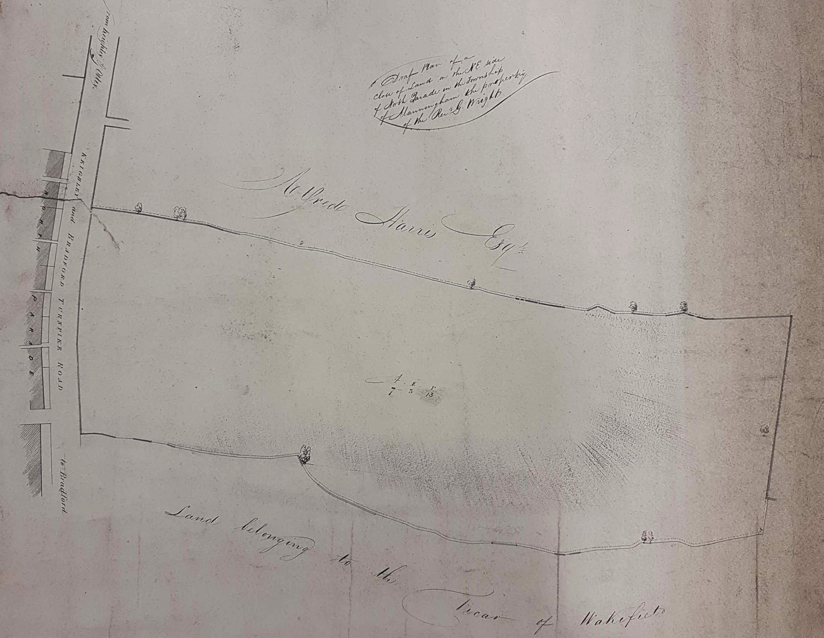
The next plan from the LSL reserve collection is roughly contemporary, but its location is south-east of the first. North Gate is on the extreme left but otherwise the area is devoid of buildings. This plan is annotated on the back and reads ‘A field on North Parade (belo)nging to Rev G (Wr)ight’. This particular plot of land is over 7 acres and 3 roods in area and is north of property owned by the Vicar of Wakefield. I was surprised to learn that the Vicar of Wakefield owned land in Bradford. The unnamed stump of road on the extreme left of the map is Drewton Street. The equally unnamed road leading off right from the upper part of the turnpike is Trafalgar Street which is still present today. At the time of the first OS map in 1852 if you walked out of Bradford on the right-hand side of Manningham Lane you would pass our plot, still empty, then a plot containing Hallfield House and three cottages, next would be Trafalgar Street, then Spring Place with Spring Lodge, and finally Holy Well. I imagine that our plot is now occupied by the Sovereign Health Care building and its carpark.
Alfred Harris (1801-1880), together with his brothers Henry & Charles, was a Quaker banker in Bradford managing the Bradford Old Bank. Alfred was the youngest brother and Cudworth states that he became a partner in 1824. He is resident at Spring Lodge (which he had built) by the 1841 census, and the 1850 Bradford Trade Directory confirms that he was still at Spring Lodge a decade later. Harris is most famous for heading the development of the Bradford Fever Hospital in Leeds Road.
Hallfield House and its attendant cottages are also on the 1852 OS map. It is described as a ‘Mansion House’ when it and the cottages are advertised for sale in the Bradford Observer in 1856 and again in 1865. It is described as in occupancy by Mr C Walker and the late residence of Henry Leah (an ironmaster). It survived to become the Christian Science Reading Room.

The final plan detail must be from about 40 years later, and forms part of the collection at Bradford Industrial Museum. The plan is on a different orientation but the presence of Drewton Street and Trafalgar Street will help you to orientate yourself. Bradford centre is towards the Snowden Street end of the plan. Springfield Lodge is present and you can see that several Bradford institutions have now been constructed: Hallfield Chapel (Baptist 1862), the Theatre Royal, opened in 1864 as the Royal Alexandra and famous for being the site of Sir Henry Irving’s last performance, and The Girls Grammar School (opened 1875). Don’t look for them now.
