
It is embarrassing to report that not only is this map undated and unlabelled, but that I also have no recollection of taking the image. The image ‘properties’ do give my name as the author, and 2011 as the original date. That being the case I think that it must be part of the map and plan collection held by Bradford Industrial Museum. To make this long, thin, map readable I’ll split it into three sections, starting from the right. Believe me the effort to understand it will be worthwhile.

In reality the map shows a strip of ground in the north-west direction from Baildon village. The prominent red and blue square must represent the first Baildon Moor reservoir. To the best of my knowledge the three component water storage ‘tanks’ that were ultimately present were built separately. Since the map shows only a single storage tank it must date from early in the reservoir’s history, say around 1850. The reservoir does not feature on the first Ordnance Survey map of the area published in 1852, but the surveying for this was being undertaken in the late 1840s, so its absence is not a problem.
If you accept this identification, then the straight blue line connecting the reservoir to Moor Gate must be an underground conduit carrying the water supply to Baildon village. Below this conduit is an obvious, blue, surface watercourse. This watercourse is present on the first OS map too, but it is not named. From Moor Gate a road heads off north in the general direction of Otley (really Hawksworth), but at the top of the map there is a branch off to the left which still crosses Baildon Moor today in the direction of Bingley. At this point on the OS map is a sandstone quarry, of which there are several on the moor. Several smaller trackways are also drawn. Similar features are present on the OS map, although their routes do not coincide exactly. I assume that these are essentially ‘extraction tracks’ which once serviced ‘the old coal pits’.
Today Baildon Moor is a very important industrial archaeology site, covered with the remains of old mine shafts. These once exploited the Hard and Soft Bed coal seams in the Lower Coal Measures. Baildon Moor represents the northernmost extension of the great Yorkshire & Nottinghamshire Coal Field, although it is severed from its main body by the Aire valley. If you can’t visit the moor to see these remains, then they show extremely well on the computer application ‘Google Earth’. It is perfectly possible that coal was being mined more or less continuously between the 16th and 19th centuries.

On this section of the map the straight blue lines must represent more conduits which in this situation are supplying the reservoir. I think these are underground but in two places they are evidently fed by natural watercourses. Again, several unnamed watercourses are present on the OS map but Acre Howe (or Acrehowe) Well is named on both. The curving roadway accessing it also features on both maps. Once more old coal pit shafts are marked both north and south of the moor road. At the extreme left of this section a ‘coal drift’ is indicated. It was almost certainly functioning at this period. For one thing the word ‘old’ is not included, and it is known from other sites that drift mining (that is accessing a seam down an inclined plane from the surface, rather than by a shaft) was a late introduction in the Bradford area. Where was this drift? It’s not hard to work out its approximate location but it does not feature on any OS map so its duration of operation must have been short.
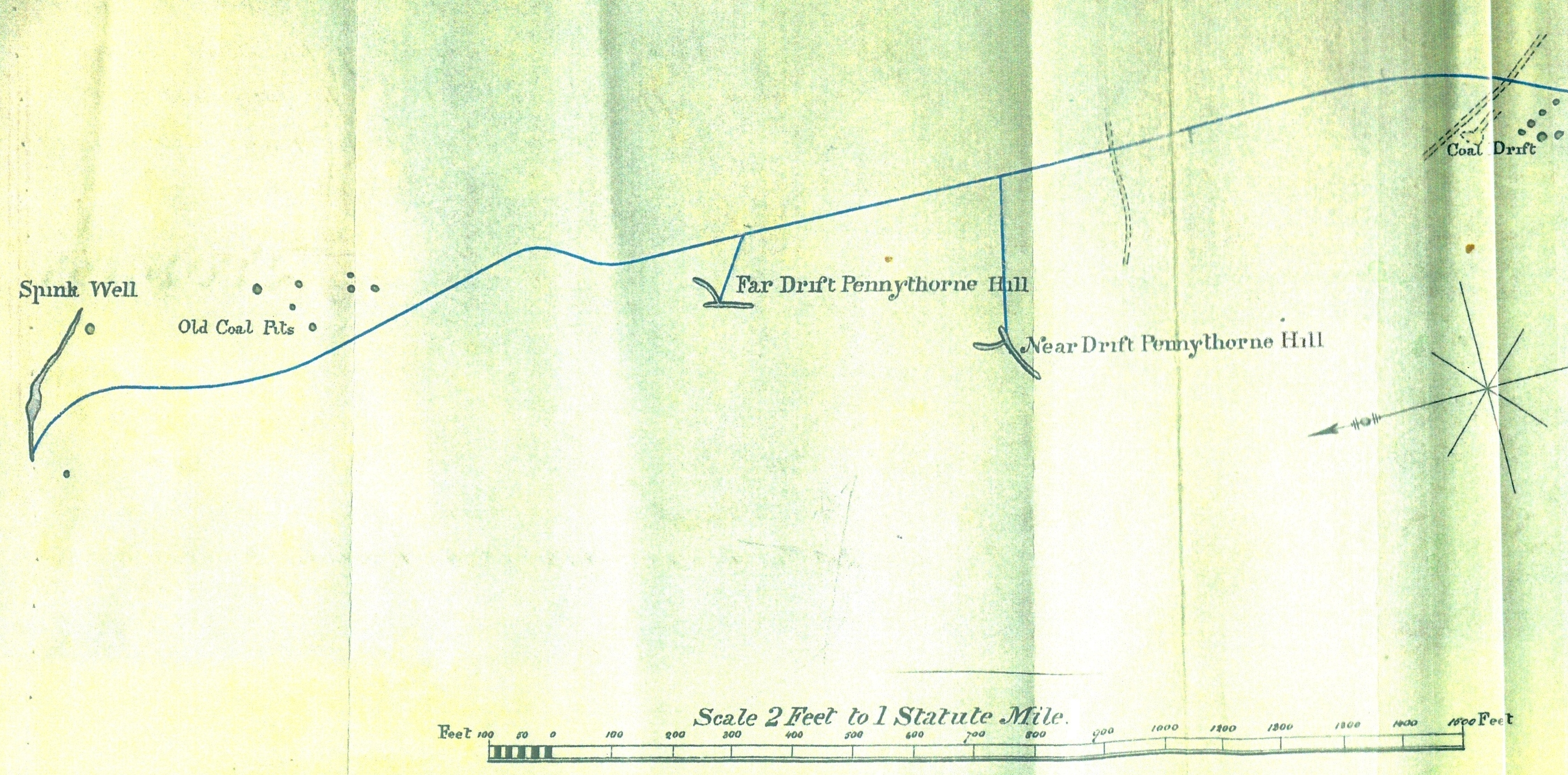
The final section indicates that there are water collection points at Spink Well, also Near and Far Drifts on Pennythorne Hill. I believe that ‘spink’ is an old country name for the chaffinch. Spink Well and Pennythorn (sic) Hill feature on the first OS map, but no drifts are indicated. The fact that our map identifies these as ‘drifts’ but not ‘coal drifts’ might indicate that the surveyor differentiates them in some way. Evidently, since they are water collection points, no active mining can be occurring. A collection of old coal shafts are indicated around Spink Well. The number and the arrangement of the shafts do not closely resemble the OS map, although its not clear if in either map the positions of the shafts are accurately surveyed, or are represented in a way that merely approximates to their position and number.
Subsequent OS maps don’t help the interpretation very much. The 1889-91 survey show that two more reservoirs have been constructed. Pennythorn Hill is still unmined but large numbers of old pits are present to the north and south. If you continued to walk in the general direction we have been following you would end up near Dick Hudson’s and In modern times much of the land is a golf course where old shafts are clearly visible on the fairways. The development and tipping occurring at the old reservoir site has been controversial for at least a decade. The location has now been taken under the protection of Bradford Council.
