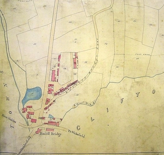
4.008 BAI c1850 PLA BHM 1322 B19
Material: cartridge paper Scale: unknown
Size: 70 * 34 cm Condition: good
This is another plan previously included in Bradford Local Studies Library’s ‘Map of the Week’ series. Bailiff Bridge’s name presumably derives from the bridges built over the Wyke Beck at this point. It was notable, over many years, for the presence of Firth’s carpet mill but this lovely example from the LSL’s reserve collection long pre-dates that period.
The first problem is how to orientate the plan. The first example is approximately correct with the Bradford-Huddersfield road running N-S, and the Halifax to Dewsbury and Wakefield running W-E. The water course that appears rather mysteriously among the block buildings is actually the Wyke Beck which takes a serpentine course from due south. In the subsequent details north is not at the top and the Wyke Beck drawn there in reality runs approximately north-west, not due west as the map appears to suggest. If you rotate the details 45° clockwise the Wyke Beck is in the correct position and now at the bottom right of the map there is a prominent acute angle (V) made by the turnpike to Huddersfield and the road to Halifax. The only problem is that this manoeuvre displaces the road from Bradford and Wyke or Wike.
The presence of the ‘new turnpike road to Huddersfield’ is helpful for dating purposes. The Halifax, Bradford, Leeds turnpike was being planned and constructed in the mid-1820s. Clearly this, and the section to Huddersfield, was completed by the time the map was surveyed, which probably dates it to the early 1830s.
We can reasonably assume that the collection of stables and farm buildings shown in the second map preceded the roads since they are not at all on the same alignment. There is a public house drawn, although not named. I made some progress with its name after computer searching nineteenth century newspapers, an electronic resource that Bradford Libraries provides. The Leeds Mercury reports that on various occasions in the period 1813-16 those executing the Wyke Inclosure Act met at the house of James Pollard, The Bailiff Bridge Inn, township of Wyke, in the parish of Birstal. Five years later similar reports of property sales in the area indicate that they took place at the ‘Punch Bowl Inn’. I assume that these two places are one and the same. At any event the Punch Bowl Inn must be correct because this features at the right location in the first OS map of the area, surveyed in the late 1840s.
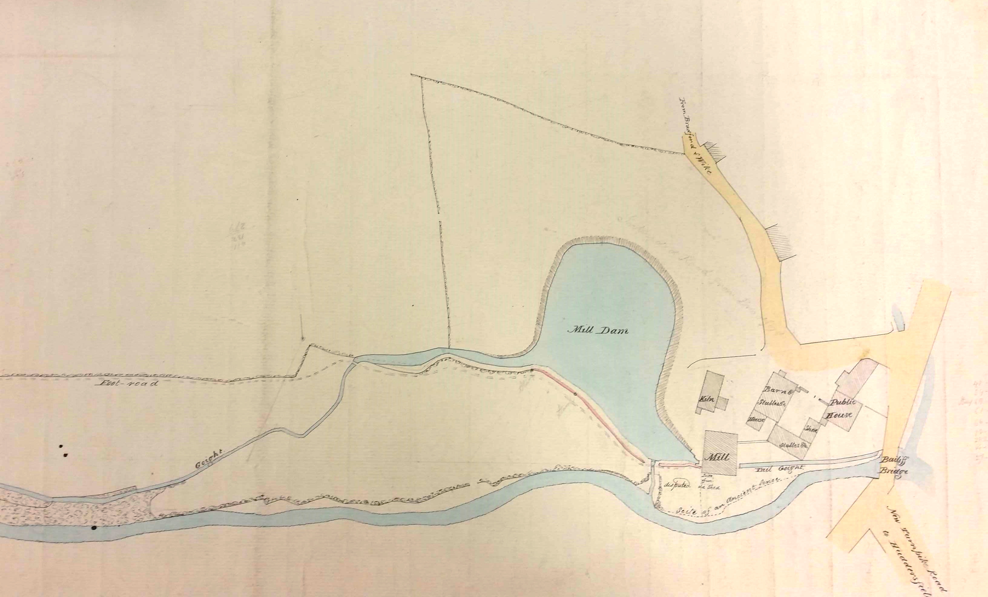
The mill dam (or pond on the OS map) and the mill itself is clearly marked as you can see. Clearly this is a water powered corn mill, and an on-line resource (Malcolm Bull’s Calderdale Companion) states that one Jonas Wright was a corn dealer here in 1822, and further that the mill was owned by the notable Richardson family of Bierley Hall, Bradford. Our map shows the tail race or goit, called here the ‘tail goight’, returning water to the beck. There is also a short water course connecting the mill dam to the beck which must be a weir and overflow channel constructed to stop the dam over-filling.
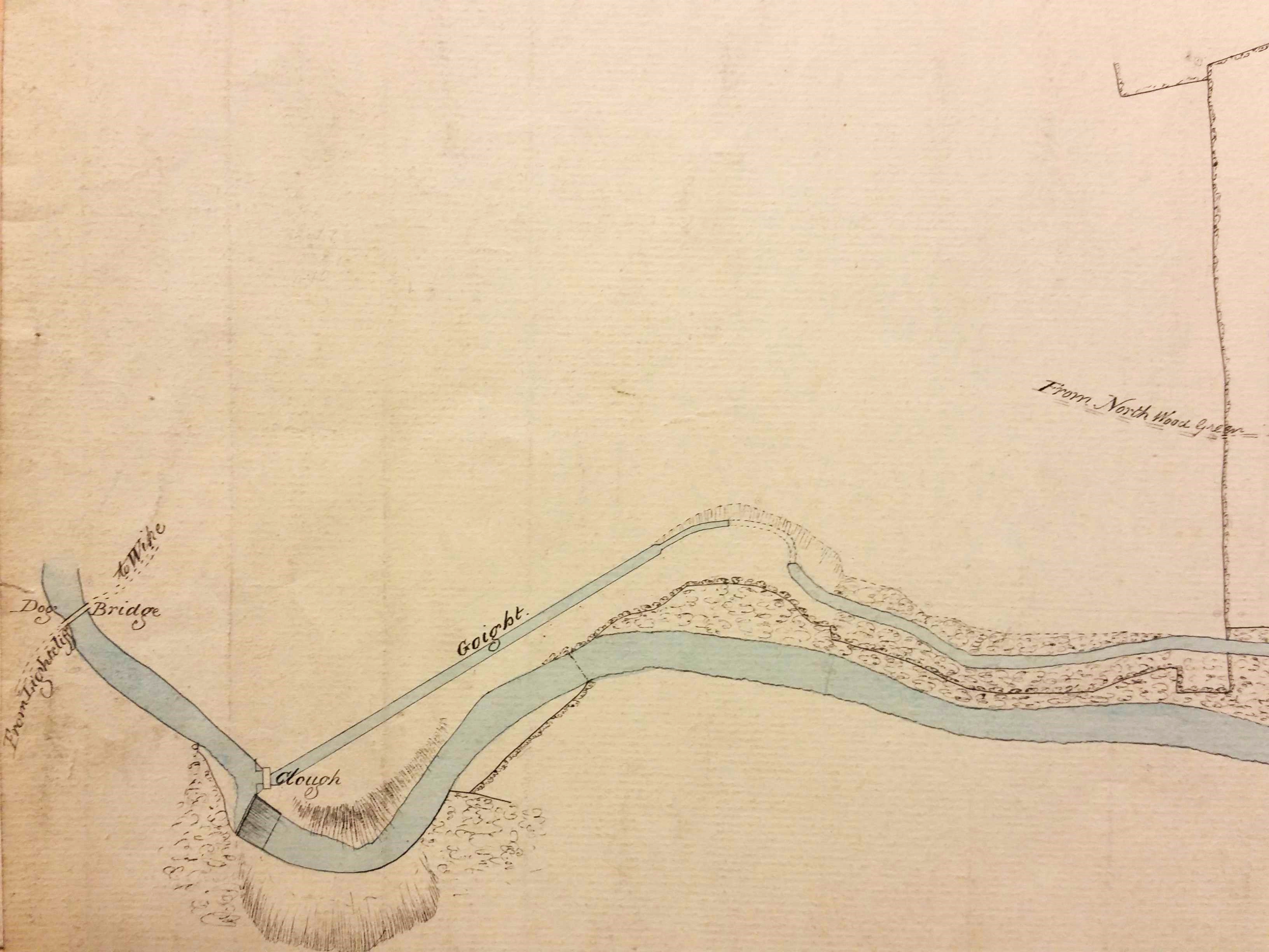
The second detail from the map shows the origin of another ‘goight’ conveying water from the beck to the mill dam. Adjacent to the origin is the word ‘clough’. I’m not sure exactly what is intended by this description. In this area ‘clough’ is a wooded valley with a beck, and the spelling is often modernized to ‘cliffe’ or ‘cliff’, a well-known example being Northcliffe Woods in Shipley.
Among other features of this delightful map is an area of disputed land: such a dispute might well explain the maps origin. Adjacent to the mill we have discussed is a kiln. What function does this serve: a brick kiln, a pottery kiln, a lime kiln, or a malting kiln? A malting kiln, drying germinated barley into malt, seems most probable. There would be a ready use for this commodity if the pub did its own brewing. Again, the Leeds Mercury is helpful. In 1832 there is an advertisement concerning ‘Bailiff Bridge near Brighouse’ where at the Punch Bowl Inn there was a sale of land by auction. Lot 2 consisted of a dye-house, bleaching works, and a close of land. There is a comment to the effect that ‘this lot may be turned into a malt kiln and brewery’. Perhaps it was. Incidentally at this early date bleaching involved spreading damp cloths outside to be exposed to the sun. ‘Bleach fields’ were employed for this purpose.
By the time of the first OS map our corn mill seems to have remained while Holme Mill (woollen) and Bailiff Bridge Mill (woollen & cotton) have been newly constructed. But there are a few other events in the history of Bailiff Bridge that I must record. In 1839 there was a steeplechase held there. Four horses competed over a 3¼ mile course, and 14 subscribers invested 5 guineas in the event. Mr E. Dyson’s ‘Sir Mark’ won. Mr Wheatley a veterinary surgeon, presumably overcome by the excitement of the event, mislaid a brown bull and a terrier dog called Crab. He advertised for their safe return in the Leeds Mercury, and I do hope he got them back, especially Crab who must have been named after the only dog to feature in a Shakespeare play.
Finally, in ‘the year of revolutions’, 1848, the Bradford Observer reported that HW Ripley had erected a school-room in Bailiff Bridge. Sir Henry Ripley (1813-82), as he became, was the principle partner in the Bowling Dyeworks and was eventually a very wealthy man. Some years after the gift of the school he constructed the workers’ village of Ripleyville, which has a good claim to be Bradford’s own Saltaire. When the school was opened Rev J Glyde addressed a celebratory meeting on the subject of education. Jonathan Glyde was the minister of Horton Lane Chapel with an enviable record of concern for society’s less advantaged. The school was just erected in time to feature on the first OS map and must have been roughly where the upper hatched block is on the road to Wyke.
