2.130 BRA c.1850 NEW BHM 1917 B28
Material: tracing paper Scale: unk
Size: 54*40 cm
Condition: very poor (handling repairs)
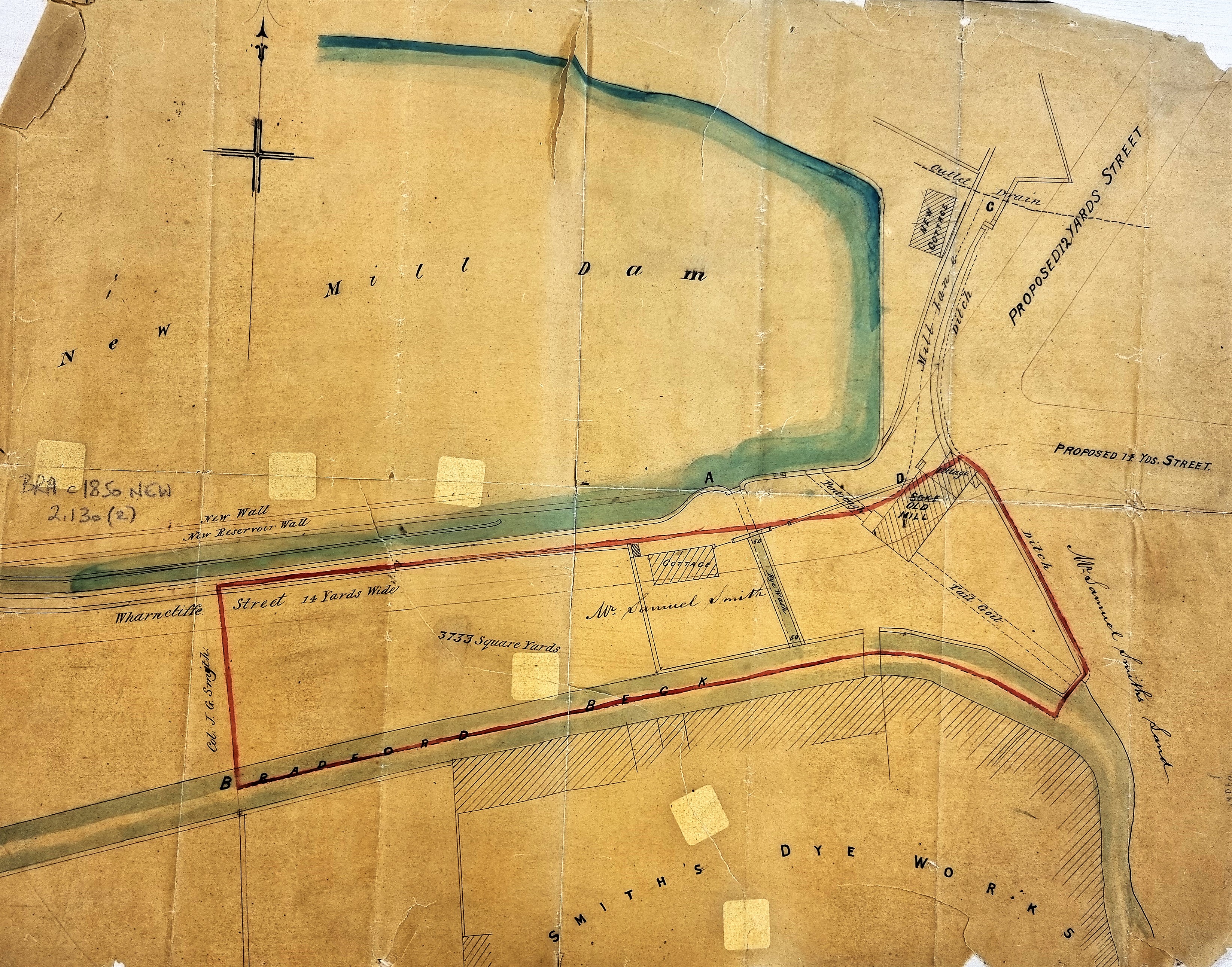
Firstly, where are we? This plan describes an area placed immediately west of one already included in this online series (X21 – MAN c.1855 BRA) which I described as ‘Bradford Beck between Manningham Mill and Thornton Road: mid-19th century’. Just off the map on the top right corner would be the junction, near the city centre, of Thornton Road and City Road (then known as Brick Lane). There was once a Brick Lane Toll Bar, but this seems to have been placed much further west. The first Ordnance Survey map, c.1850, shows that immediately south-west of the junction was New Mill Dam, part of which is shown on this plan. To the right of the dam, Mill Lane led to the Manningham Soke Mill. This was marked as ‘not in use’ at the time of the first OS map. The use of a water-mill to grind the Lord of the Manor of Manningham’s corn, and that of his tenants, must surely have ceased many years earlier.
South of the dam there are some clear differences between this plan and the 1850 OS map. The plan marks Wharncliffe Street, whereas the OS map indicates only a footpath. Further south still is a portion of land, and then the Bradford Beck. Beyond that is a large dye works which is described as ‘Smith’s Dye Works’ and is a prominent building at the bottom centre. In the OS map a dye-works of a somewhat different footprint is called ‘Field Dye Works’. It is not really feasible to follow the further development of this area in OS maps. By the time of the next, in 1890, everything (except the short open section of the Beck) has been swept away to be replaced by railway marshalling yards. There is neither dam nor dyeworks.
I imagine that the purpose of this plan is essentially to support the sale of the land between Bradford Beck and dam, which is outlined in red. One reasonable assumption is that if our plan pre-dates the first OS map the ownership of the dyeworks has changed from Field’s to Smith’s Dye Works. But, in fact, we are probably looking at the same enterprise namely that of Samuel Smith (stuff dyer), who in an 1850 directory was placed at Field Dyehouse, Thornton Road. Stuffs were worsted pieces. A fire occurred at ‘Smith’s Dye Works’ in March 1848 (Bradford Observer). Samuel Smith is probably the landowner selling the outlined section of land; other landowners in this general area, who are not mentioned on this plan, were George Baron of Clockhouse Estate and Thomas Hollins of West House, Toller Lane (stuff manufacturer).
Two goits are taken off New Mill Dam to supply the Dye Works and the old Soke Mill (Pentrough & Tail Goit). New Mill Dam I can trace back to 1819 (by virtue of people downed in it who then were recorded in local newspapers) but it is not included on the 1802 Bradford map. However, Cudworth records that the New Mill(er) Dam was created by John Smyth of Heath, near Wakefield, around 1777. His family were associated with the estate of Miryshay, off Barkerend Road.
