3.002 RIB c.1770 PLA BHM 2022 B29
Material: cartridge paper Scale: unknown
Size: 48 * 35 cm Condition: fair
Lack of dates and unstated purposes are commonplace in the maps used for this online series. This particular plan has an additional uncertainty over the circumstance of its acquisition. The Local Studies Library has a number of reserve maps showing places nowhere near the city of Bradford, although they are usually from elsewhere in Yorkshire. What the connection might be is now mysterious. Most of the maps in the collection, like this one, seem to have reached the library in the 1960s from Bolling Hall Museum. They all seem to have been stamped with a BHM admission number, so it is entirely possible they were catalogued on acquisition: but if this was so then no catalogue now remains for me to consult.
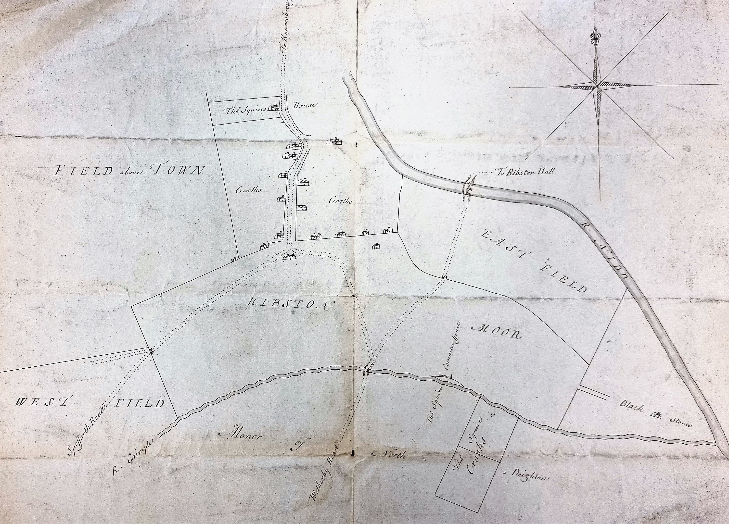
There is no doubt what this beautifully drawn plan portrays. Ribston Moor is clearly marked and a bridge over the River Nidd evidently leads to Ribston Hall, which however is itself not drawn. Ribston Hall was a seventeenth century construction which places some restraint on the age of the plan. When I originally examined the plan I felt that stylistically it was from the eighteenth century. I gave it a provisional date of c.1770 since the local Enclosure Act was of this date. On refection it clearly predates enclosures so perhaps c.1750 is a more likely.
Ribston Moor is between Harrogate & Knaresborough. At the base of the map is a section from the neighbouring manor of North Deighton. The plan shows the confluence of the rivers Crimple and Nidd at Blackstones, which means you can identify its location exactly. This makes comparison with the first Ordnance Survey map of the area (surveyed late 1840s) very easy. If we do at comparison then it is clear that the River Crimple meanders far more than our plan suggests. The plan indicates that the land is sub-divided into common land (moor) and three great fields: East Field, West Field, and Field above Town. By the time of the OS map the common land has been enclosed and the great fields subdivided. I assume that the bridge over the river Crimple is the Crimple or Ribston Bridge. The bridge over the Nidd, which looks fairly impressive on our plan, has withered away to a mere ‘wooden bridge’ on the OS map.
To the left of this second bridge are a collection of houses amidst ‘garths’, and also ‘Thomas Squires house’. The name Squire appears elsewhere on the plan which must indicate he was a person of consequence, but identifying him would require more time, and more family history skills, than I can offer. The house collection is in the process of evolving into the village of Little Ribston, which is named in the OS map.
There are a couple of additional pieces of information which may be of interest. The River Crimple or Crimple Beck is said to have provided the name for Crimplene, a synthetic fibre and derivative of Terylene. ICI had their headquarters at Harrogate at one time.
At the presumed time of the map Ribston Hall was the home of the Goodricke family. They lived there between 1542 and 1833. The owner at the time of this plan was presumably Sir John Goodricke 5th Baronet (1708–1789), who was a British diplomat and politician, who was an MP between 1774 and 1789. In 1833 Sir Henry James Goodricke (7th baronet) died unmarried and the property passed to a relative, Sir Francis Holyoake-Goodricke, who sold Ribston to a Joseph Dent in September 1836.
The Dent family retains ownership. Ribston Hall was already famous for being the original home of a well-known apple, the Ribston Pippin. This was first cultivated in the early eighteenth century. So, who did Sir Arthur Conan Doyle describe as “a little Ribston pippin of a man, with ruddy cheeks and fluffy side-whiskers”?

Found this just as interesting as other posts – I do love comparing these draw maps with the present-day topography one can see with Google Earth – It’s interesting to note that a building structure exists where Black House stood back then – I also noted that there is a chapel at the folk of the roads which was built in 1818 which comes after the date of this map and of course isn’t present on this map.
LikeLike