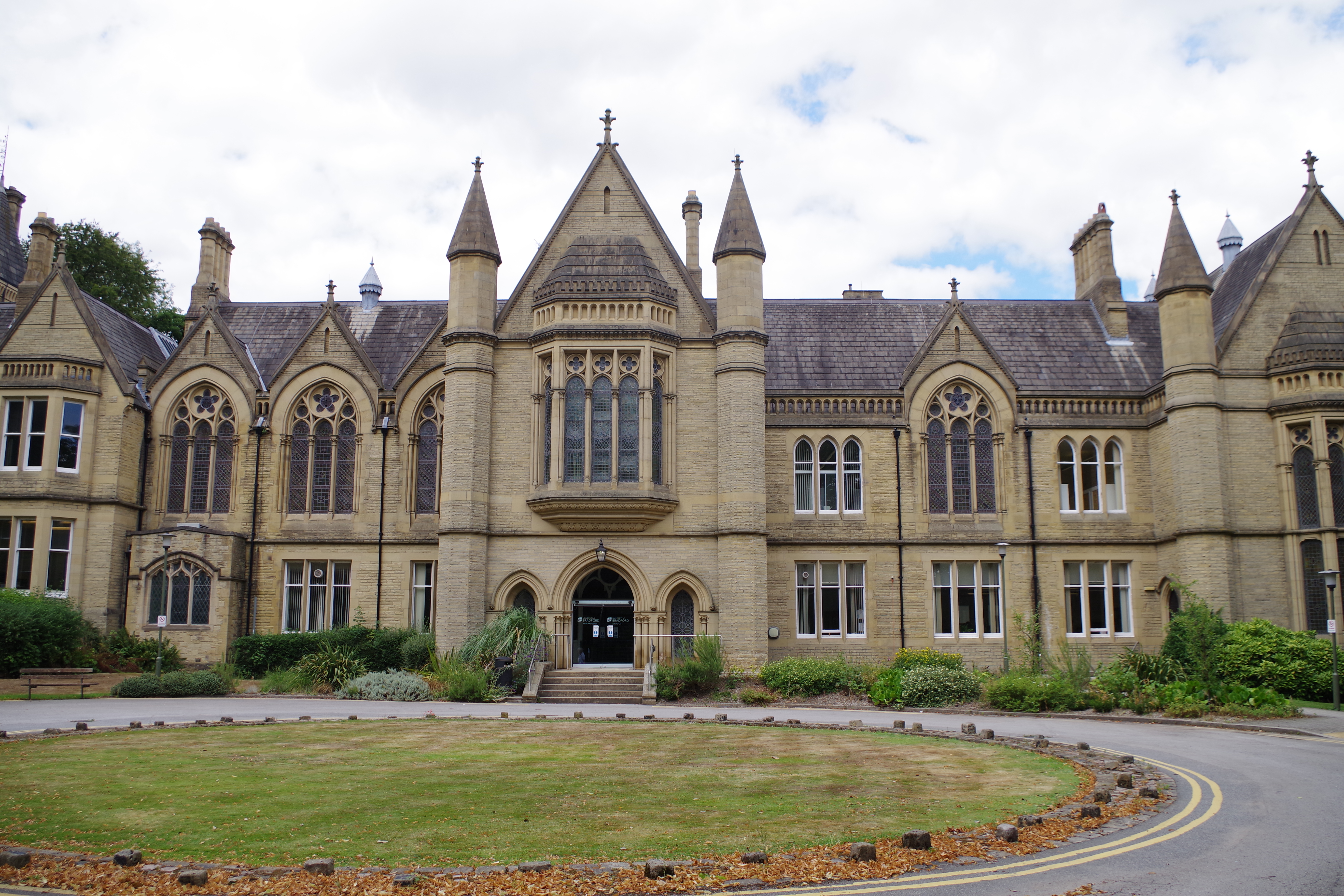
This beautiful Grade II listed Victorian building, just off Emm Lane in Heaton, had formed part of the University of Bradford’s Management Centre since 1963, but has recently (2021) been sold. The architects were the famous partnership of Lockwood & Mawson. When I published this photograph in a different forum I noted that at least one very talented local historian didn’t recognise it, nor knew how it came into existence. I am writing this account with her in mind, but I hope it will be of general interest as well.
Maps in the Bradford Local Studies Library collections are seldom found wanting when it comes to resolving questions of this type. However, it is also true that old plans of Heaton, my own part of Bradford, are not very common in the LSL map collection. In the eighteenth and early nineteenth centuries a great deal of the land in the township was owned by the Field family, Lords of the Manor of Heaton. On the death of John Wilmer Field without a male heir, in 1837, this estate passed, by virtue of the marriage of his daughter Mary, to a future Earl of Rosse. It was land sales that so often generated survey plans. The area identified in the first plan was not part of the Rosse estate, and so it did change hands and consequently generated interesting plans.
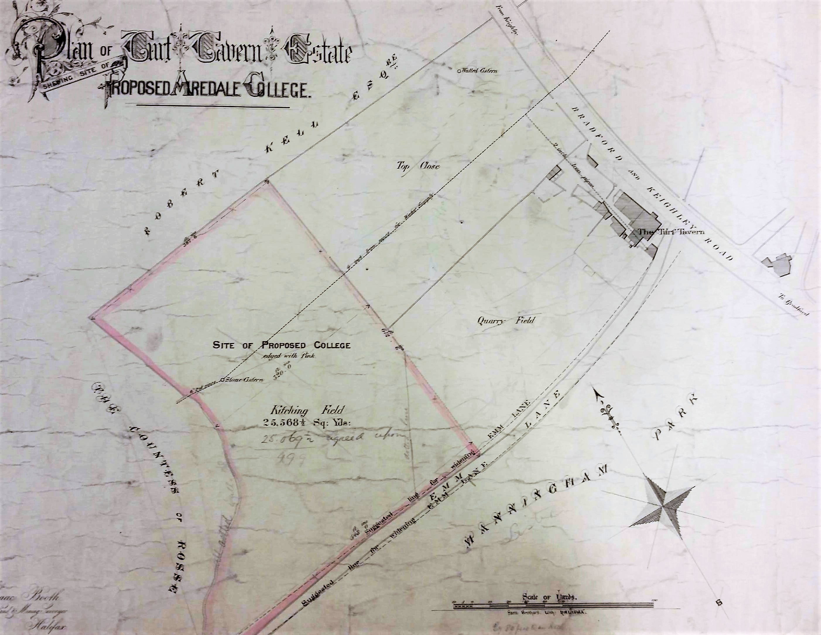
The 3rd Earl of Rosse had died in 1867 so the first plan must be later than this date since his widow, Mary Countess of Rosse, is identified as a neighbouring landowner. She took over the direction of their Heaton and Shipley property until her own death in 1885. By this time portions of the estate were being offered for sale with villa development in mind. The present Earl of Rosse still maintains an archive at Birr Castle, Co. Offaly, Eire where many historic maps and documents are curated. But any questions readers might have about Heaton history can almost certainly be solved more conveniently by consulting Heaton: the best place of all written by the late Stanley King whose love for, and knowledge of, Heaton is unlikely ever to be exceeded. Several copies of his work are available on the library shelves.
I would imagine that the plan probably dates from c.1875 since it shows a block of land near the corner of Emm Lane and Keighley Road on which it was proposed to build ‘Airedale College’. This was to be dedicated to the training of Congregationalist ministers. An earlier college had been in existence at Undercliffe since 1831. Possibly a larger building was needed to train additional applicants, or perhaps the development of Undercliffe Cemetery by a private company made the environment of the original college less desirable. The new premises at Heaton were finally opened in 1877.
The name Airedale College was changed to the United College in 1888, following the closure of a similar institution at Rotherham. This help dates the second plan, but a better guide is the presence of a ‘Royal Arch’ across Emm Lane from the Turf Tavern. This arch was constructed by 1904.
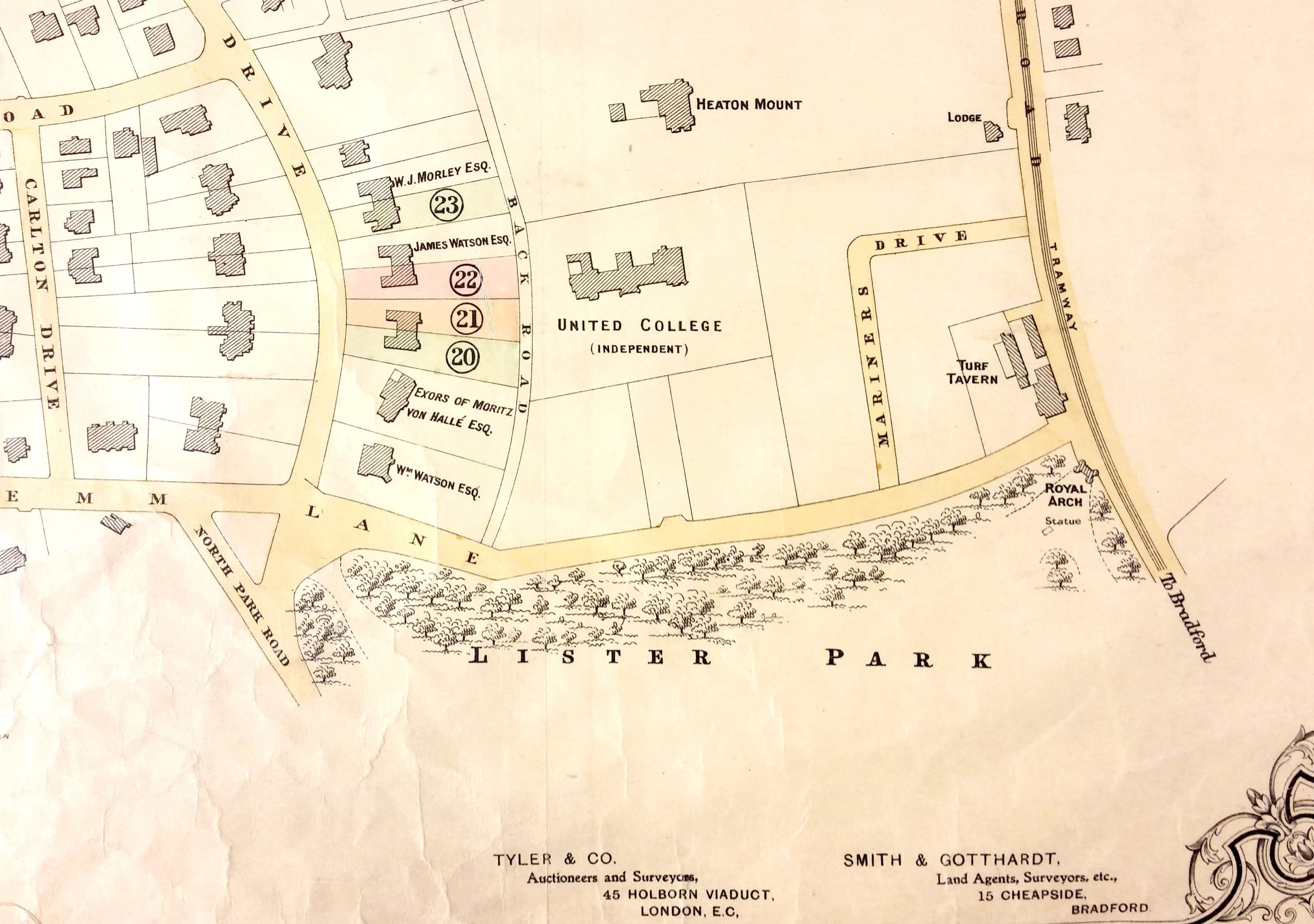
As stated, until 2019 Airedale College was part of the University of Bradford. Another part of the Emm Lane University Campus was an adjacent house, named Heaton Mount, which was built in 1863 by stuff and woollen merchant Robert Kell. The house appears near the top of the plan. Throughout this period Heaton did not form part of the Borough of Bradford; its incorporation into the borough was not until 1881. In fact, the first plan even pre-dates the construction of Heaton’s first public sewer which, according to Stanley King, only occurred in 1877. The resulting sewage was discharged straight into the Bradford Beck, which is not a pretty thought.
Back to the first plan. It looks as if the site destined for the college was part of a parcel of land called the Turf Tavern Estate. The three field names are given as: Top Close, Quarry Field and Kitching Field.
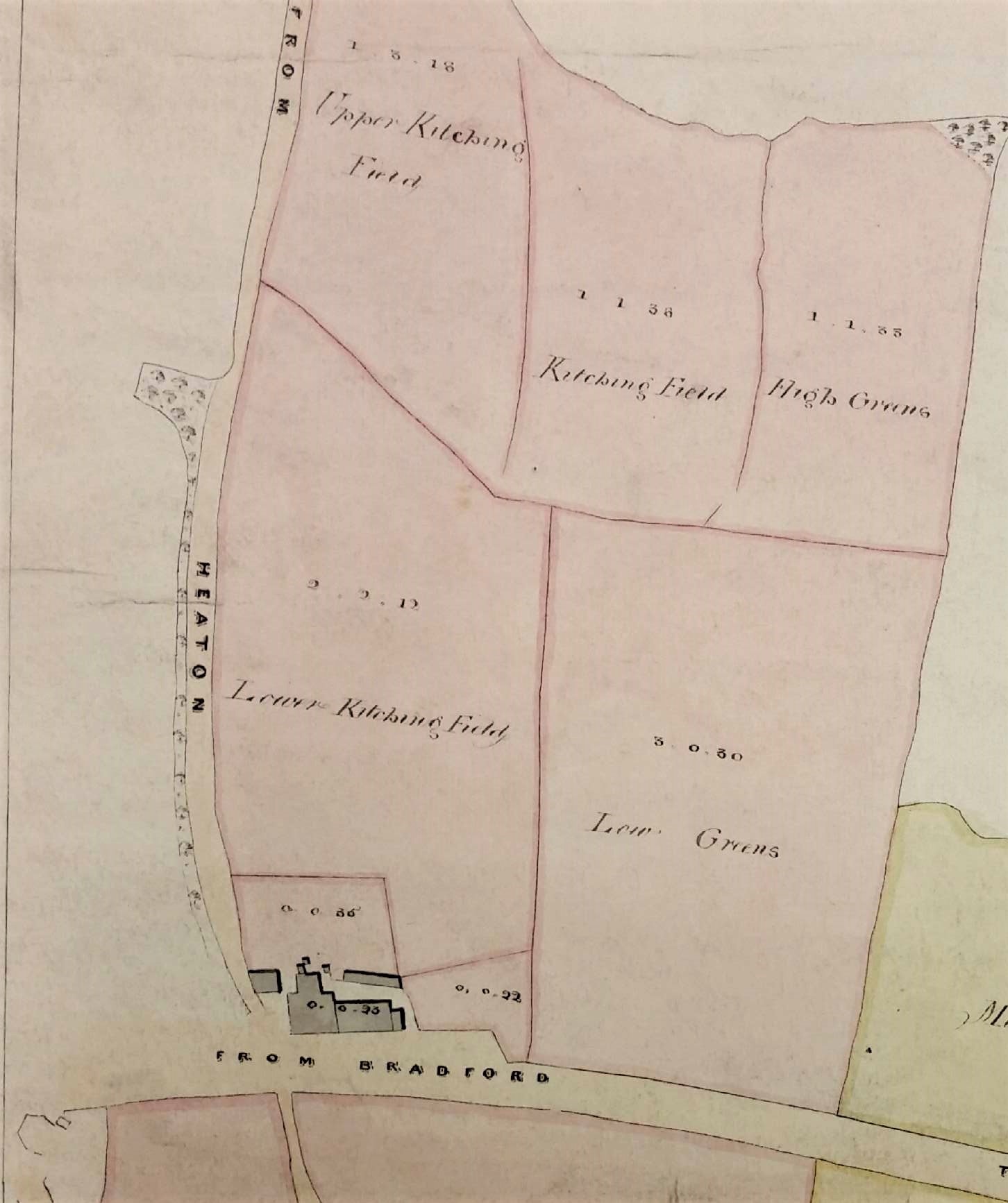
The LSL has an earlier plan of 1840, which has been rotated by 90° clockwise so that Emm Lane is at the extreme left. This plan suggests that most of the area was then called Kitching Field, Kitching being a well-known local surname. Perhaps there was a small quarry development here between 1840 and 1875 that accounted for the obvious name change. Prior to the construction of the sewer in the 1870s Heaton’s solid wastes were used as landfill in these many disused quarries, a fact not widely known to modern residents.
The Turf Tavern itself, briefly known recently as The Park and now a restaurant, is present on this 1840 map and all the OS maps of Heaton. There is a datestone above the door carved with the year 1894, but this must indicate a rebuilding since the original structure was much older. Historian William Cudworth suggests that the tavern and the nearby, but demolished, Branch Hotel (formerly the Coach & Horses), were both erected when the Bradford to Bingley turnpike was opened in 1825. He records that the builders of the Turf were William Clarke, a Heaton butcher, and his brother Joseph, a stonemason. Another brother, John Clarke, developed the many delphs or quarries around Heaton village, although all evidence of those has long since vanished.
The owner of the Turf Tavern estate at the time of the first map is likely to have been William Lister Marriner of Greengate House, Keighley. His family came into property around Frizinghall by marriage. Local historian the late Tony Woods confirmed their possession of this area from the Heaton Local Board Rate Books 1860s-1881 (WYAS Bradford Archives BBT6/5/5/1-19). The same family also gave their name to nearby Marriner’s Drive. This roadway is not present on the 1906 OS map but appears on the 1911 Rosse sale plan, without as yet any attendant houses. The sale plan was produced because in 1911 the 5th Earl sold off all his remaining property in Heaton and Shipley and consolidated his estates in Ireland.
Emm Lane was originally a track through Emm Field (perhaps originally Elm Field) when this was one of the three original ‘great fields’ of Heaton in which farmers were allotted strips of land to cultivate. Nearby Manningham Park, now Lister Park, was originally a deer-park surrounding Manningham Hall, the home of the Cunliffe Lister family. The land was eventually purchased by Bradford as a public open space and Cartwright Hall built as an art gallery and museum. The Royal Arch, which already been mentioned, is known locally as the ‘Norman Arch’, although it is mock-Gothic not mock-Norman. This was created as a formal entrance for the Prince of Wales (later king George V) when he opened Cartwright Hall and the Bradford Exhibition in 1904.

Lots of interesting information here. Especially ‘The resulting sewage was discharged straight into the Bradford Beck, which is not a pretty thought.’ and ‘Prior to the construction of the sewer in the 1870s Heaton’s solid wastes were used as landfill in these many disused quarries, a fact not widely known to modern residents.’ As a volunteer with Friends of Bradford’s Becks, facilitating workshops and events about preventing pollution of the Becks – this illustrates why if was ‘Mucky Beck’!
LikeLike