X46 HAL c.1882 KEI = KEI 1882 RAI
Size: 21” * 32” Material: Paper
Date: unk Scale: 2 chains to 1”
Condition: Good
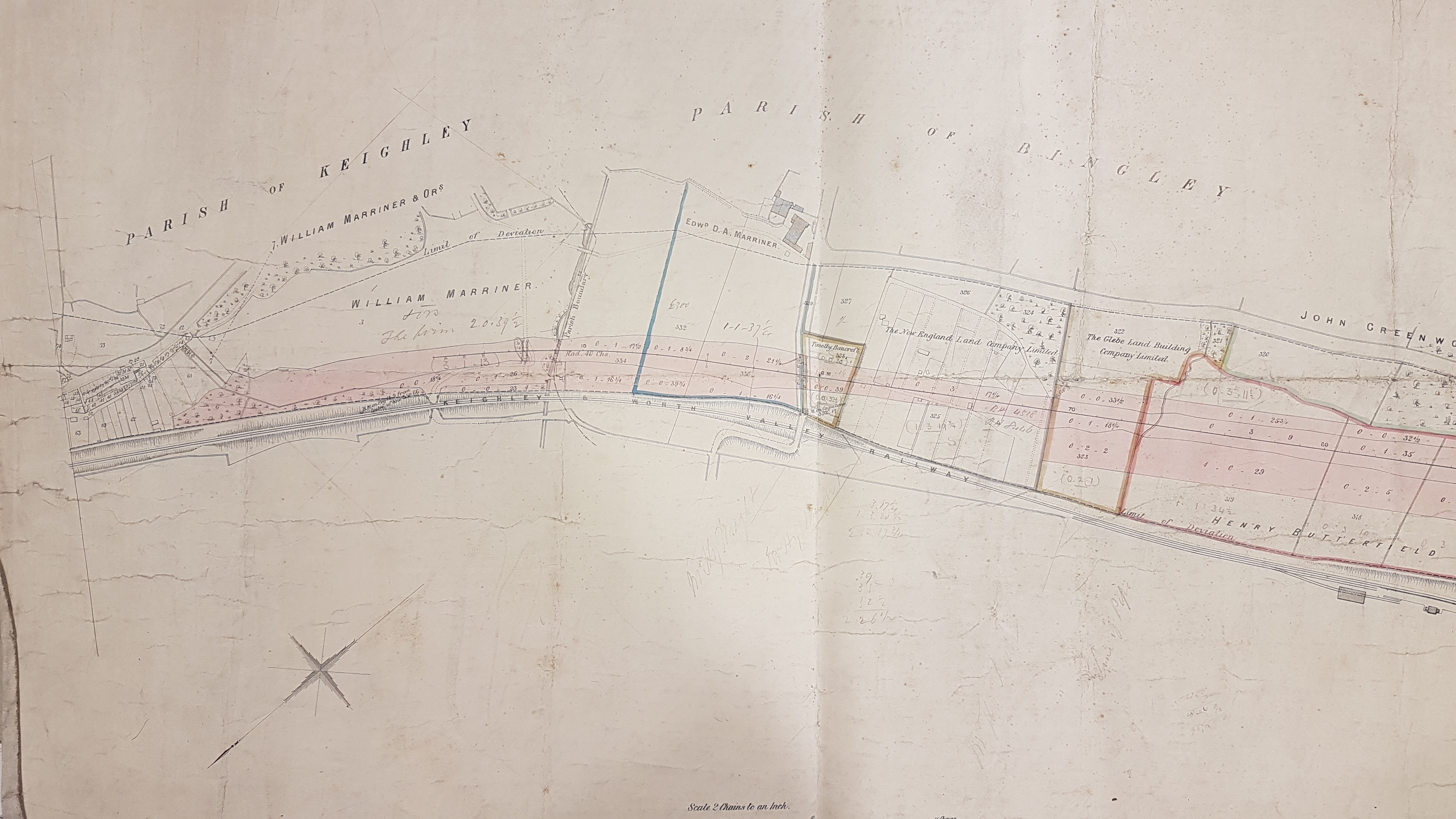
This plan’s full title is ‘Halifax, Thornton & Keighley Railway No.1: Line at Ingrow, Keighley’. There are several other copies of plans for this line in the Bradford Local Studies Library reserve collection. The railway line involved is not the mainline from Shipley via Keighley to Settle, but shows the other two lines that reached the town. As far as I know the Keighley and Worth Valley Railway was opened in 1867. The Act establishing the Halifax, Thornton & Keighley Railway company was passed in 1873, and its line to Keighley finally opened about a decade later, in 1884.

I am limited in my interpretation of this plan by two factors: I am not a railway historian, and I’m not absolute sure of its location!
The area shown is evidently near Ingrow, south-east of Keighley town centre, and plots two tracks. The Keighley & Worth Valley line (now a heritage railway) was already in existence when the plan was surveyed. In the early 1870s there was also a Bradford to Thornton line using the magnificent Thornton viaduct. What is being planned is the Halifax, Thornton & Keighley line which would link Thornton and Keighley across viaducts at Hewenden and Cullingworth. I think it is reasonable to assume that the pink tinted band is the land that will need to be purchased to construct the permanent way.
In trying to locate the position of the plan please note that the direction indicator places north towards the bottom left corner of the plan. Rotating the plan by 180 degrees makes it difficult to read, but puts HT&K line south-east of the K&WV which is the correct alignment. The course of the River Worth, which would have been very helpful in locating the site, is not drawn.
The map seems to be anchored on the right by the K&WV line emerging from a very short tunnel after Keighley station, and the tight double-bend of the road near Woodhouse also seems unmistakable. If I am correct then Ingrow itself is just off the plan.
I shall need to establish if the pink band was course for the HT&K finally adopted. I have assumed ‘No.1’ in the title meant the first in a series of maps plotting the line’s complete course. It is possible that more than one course for the line was being considered and this plan shows only the first possibility. When the Bradford Local Studies Library reopens after Covid it should be possible to arrange all the sections we have together, which should reveal the true situation.
I’m more familiar with the two notable landowners included on the map: Henry Butterfield and William L Marriner. The first must be Henry Isaac Butterfield (1819-1910), Victorian textile magnate and creator of Cliffe Castle, now a most impressive museum, in the years 1875-80. The second is William Lister Marriner (1825-1906), worsted spinner, of Greengate House, Keighley. The same family owned property in Heaton and Frizinghall, providing the name for Marriners Drive.
I assumed that the Glebe Land Building Company Ltd, and the New England Land Company Ltd were building societies engaged in house construction for their members. But I may be wrong since nothing much seems to have happened in the way of development by the time of the 1895 OS map of the area.
