Plan of freehold property situate at Hill Side, Church Bank etc. (c.1840)
X40 BRA c.1840 SMI
Size: 22” * 25” Material: Paper
Scale: 20 yards to 1” Condition: good
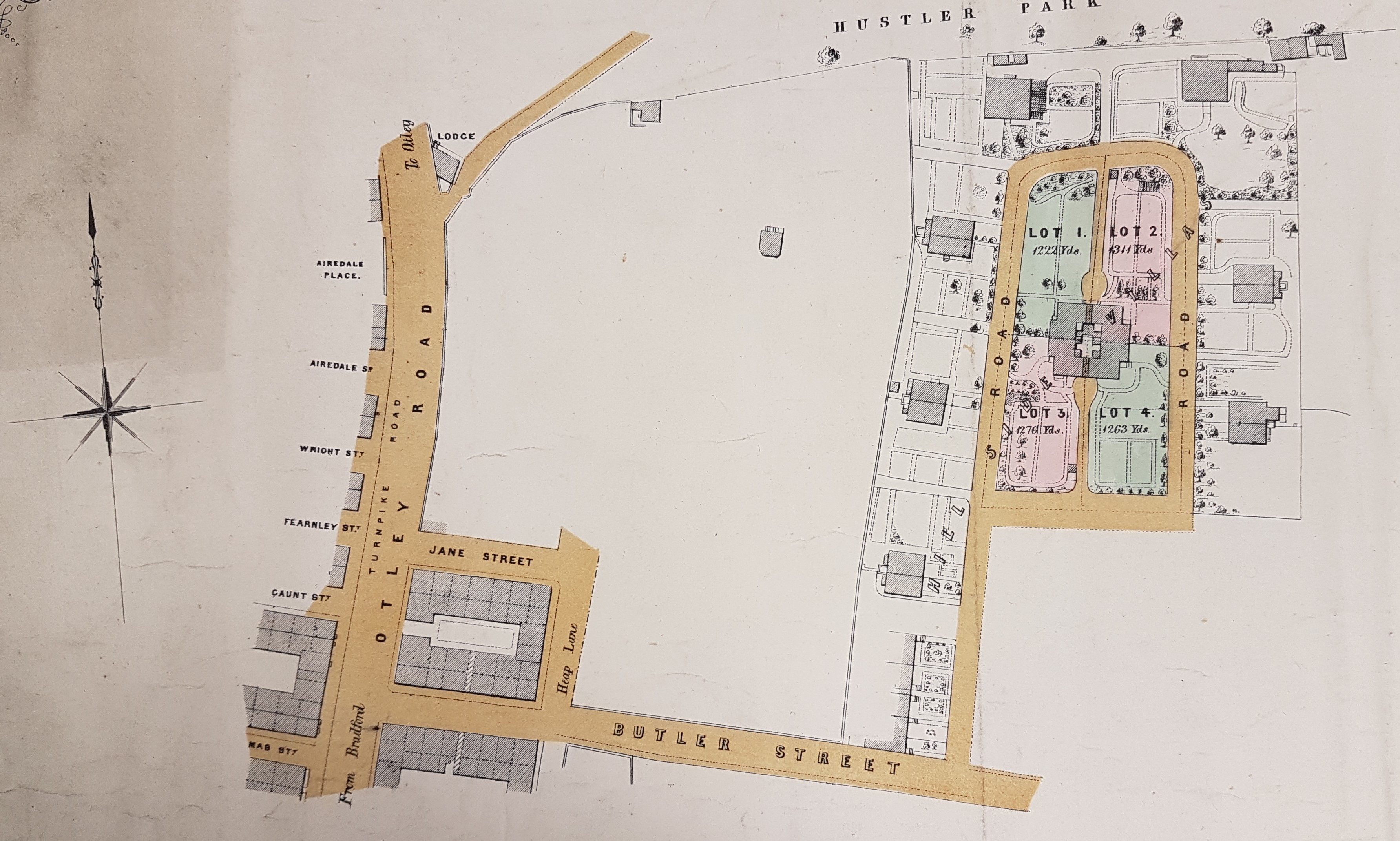
The full title of this plan is: ‘Plan of freehold property situate at Hill Side, Church Bank & Scar Hill, in the Borough of Bradford’. The surveyor is Geo B Smith. I should add that the images I have available do not show Scar Hill, but the images of Church Bank and Hillside are interesting in their own right. ‘Geo B Smith’ must surely be George Belk Smith the surveyor, son of the equally well-known surveyor and agent, Joseph Smith. George was Sir Titus Salt’s agent in the purchase of the land for Saltaire, and his offices were nearby in Leeds Road.
As so often with these sale plans no vendor is named and the plan is undated, but if Bradford is officially a borough the plan should be later than 1847, but this may not be the case. If Scar, or Scarr, Hill were involved then there are reasons for a sale in the early 1840s. There is a brass memorial in Bradford Cathedral which states that a William Pollard of Scar Hall, who married Beatrix, died in the year 1840 aged 72. Scar Hall, at Scar Hill, was at the crossroads in Bradford Moor where the appropriately named Pollard Lane joined Killinghall Road. It is now at the site of Bradford Moor Golf Club, well to the east of this plan. Could William Pollard’s estates have been more extensive and have been sold off shortly after his death? For this and other reasons at present I shall give the plan a date of c.1840.
There is another clue to the date in the plan itself. It would appear that Lots 1-4 surround a central house, then there is a perimeter road, and finally outside this are seven villas that are not for sale. This is exactly the arrangement portrayed in the first Ordnance Survey map of the area (which was surveyed in the years 1847-50), and also the Bradford plan of 1849. On the OS map the area is called ‘Hillside Villas’. Surprisingly perhaps this arrangement is essentially preserved nearly 50 years later in the second OS map. The four central lots are still undeveloped, although the area to their south, adjoining the continuation of Butler Street (which links Otley Road to Barkerend Road), is filled with terraced housing. Astonishingly the same arrangement remained until my OS maps run out in 1938, although it has clearly been subject to wholesale post-War redevelopment. The name ‘Hillside’ has been preserved in several modern buildings.
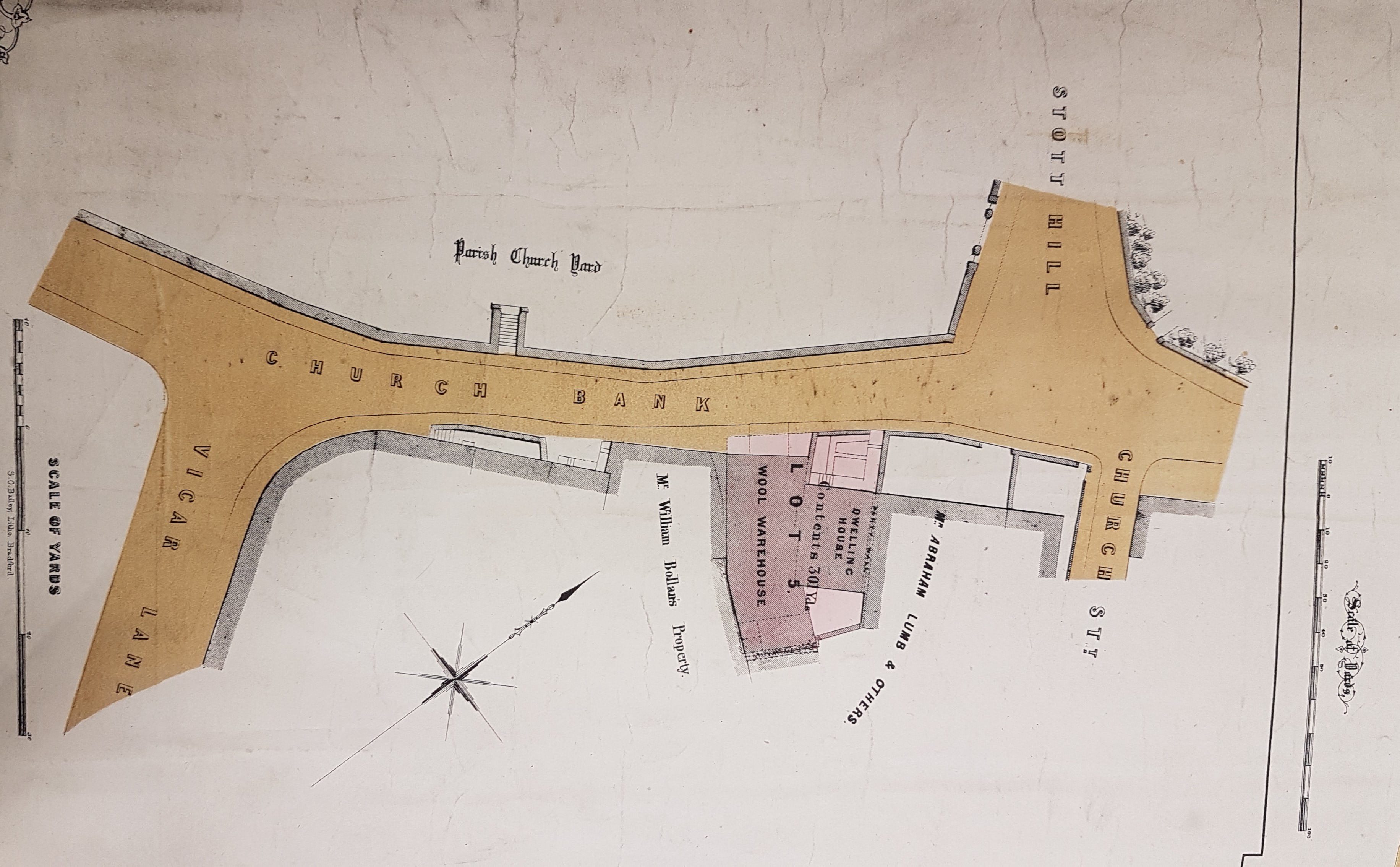
From the second map it seems that Lot 5 is a wool warehouse and a dwelling house, south of Church Bank, sandwiched between the property of William Bollan and Abraham Lumb. The OS maps don’t show this block in sufficient detail to be of any further use, but it is just east of the old Bradford vicarage. I like to link these maps with named individuals. I drew a blank on William Bollan, but in the 1851 census Abraham & Elizabeth Lumb are living in North Parade. Abraham describes himself as a proprietor of land and houses, which sounds promising. On the other hand, in 1841 he was a pawnbroker and in 1861, a retired plumber! Perhaps he had transferable skills.
When all else fails I resort to nineteenth century copies of the Bradford Observer. I have found two references to houses in Hill Side being available for letting: in 1844, and then again in 1852. In fact you could pick one up for £20 pa, or less. The man offering them for lease is one William Tuke, architect, who actually gives Hill Side as his address. It is very disappointing that I cannot yet identify him in Bradford in the censuses of 1841 or 1851. To end on a dramatic note I shall guess he is a member of the Quaker Tuke family of York. A man of this name lived from 1811 to 1874. He spent some of this time in Bradford, before moving to Manchester. Here, near Bolton, he was killed by a train during the performance of his duties.
See: William Tuke – Architect | Architects of Greater Manchester (manchestervictorianarchitects.org.uk)
