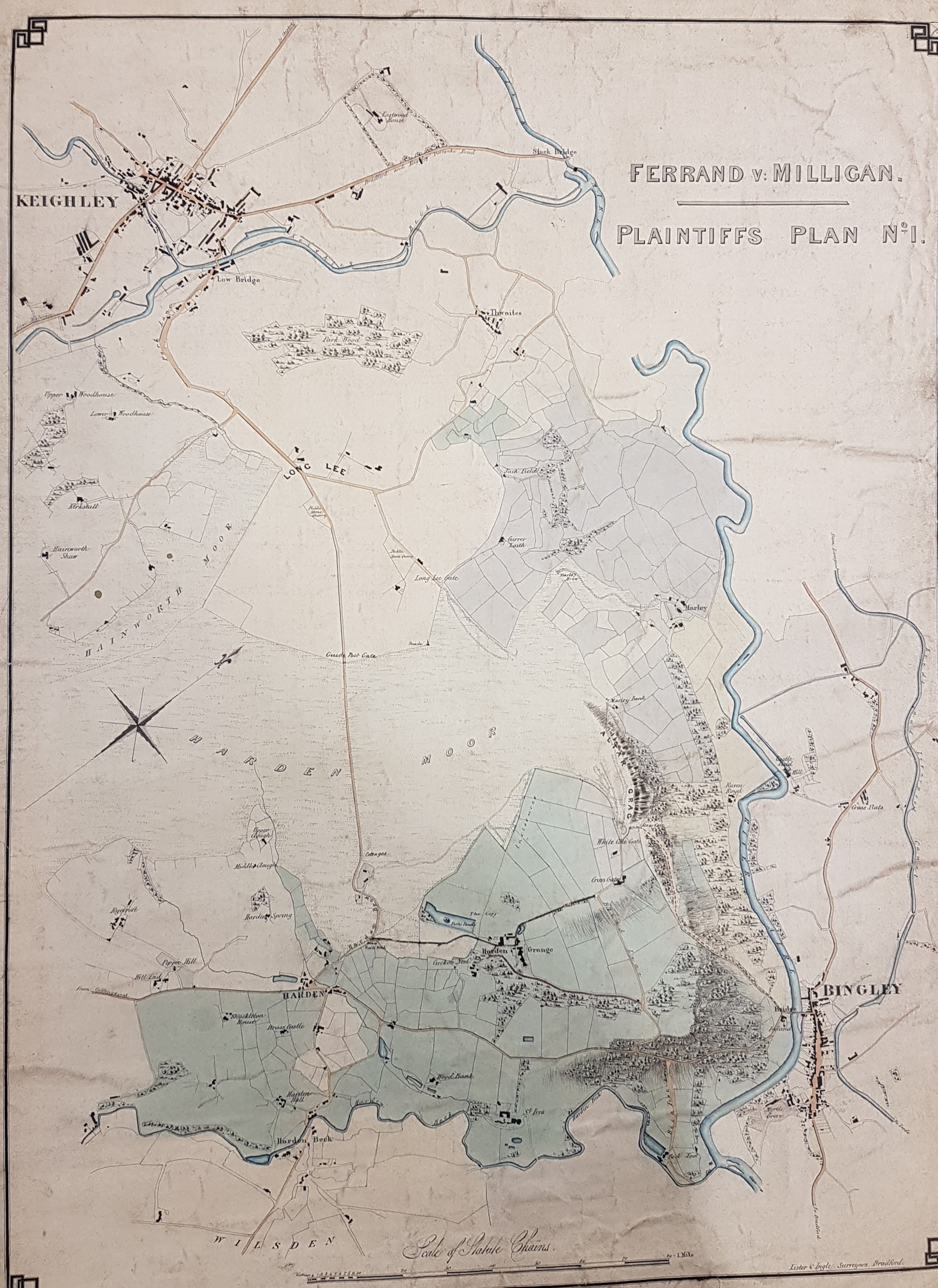
X34 Index: HAR 1845 LIS
Harden: Ferrand v. Milligan (Lister & Ingle)
Size: 17”*23” Material: paper
Scale: 13 chains to 1” Condition: good
The Local Studies Library has a collection of maps from the Wilsden and Harden areas, which I assume all originated with the Ferrand estate. In establishing the orientation of all such maps it is important to remember that Harden Grange is now called St Ives, and conversely the Victorian St Ives is now called Harden Grange. Major William Busfeild Ferrand (1809 – 1889) was MP for Knaresborough and lived at Harden Grange (whose name was exchanged for St Ives). The plan portrays the Harden Grange and St Ives estates, which William Ferrand was ultimately to inherit from mother his in 1854.
This example is marked ‘plaintiff’s plan No 1’ which dates it to a legal case in 1845. This action was brought to ‘try a right’ (in the person of Robert Milligan, surveyor of the roads) to determine whether the public were permitted to use a road to Harden Grange (now, you remember, called St Ives). Milligan clearly believed he had a right of way past Ferrand’s house, but the jury found that the thoroughfare in question was ‘no carriage road or public foot road’. Despite his victory the plaintiff (Ferrand) was awarded a derisory one farthing damages. An associated criminal case saw the luckless Milligan hauled up for ‘riot and assault’, but this case was eventually dropped. A year later the defendant tried to renew the action, but this was not allowed by the court.
I’m particularly interested in the area called Harden Moor at present, which is still very well worth visiting today. It is likely that a pair of Roman roads cross here and even the untutored eye can easily see on the ground that the whole area has been very extensively quarried for stone. The solid geology of the Moor is the upper part of the Millstone Grit sequence – the Rough Rock and the Rough Rock Flags. No trace of this industry is present on our plan, although quarries are drawn on the first OS map of the area (1852) and are greatly augmented by the time of the next OS map around 1895. I would very much like to know if we have caught the genesis of the stone extraction industry in the years between 1845 and 1852, but perhaps it was simply that quarrying on common land was of no interest to our map surveyor. As Lords of the Manor the Ferrand family would have had rights over sub-surface minerals like stone and coal even if the common or ‘waste’ was not owned by any individual.

Hi Map Collections,
Can you assist me, the emails I get when new maps are added are fine, but when I open the map it doesn’t show full size or enable me to enlarge or reduce to the size of the map. After a few days then it becomes “active” and enables me to open and enlarge or reduce at will. Is there a reason for this? Is there anything I can do to make it work better??
Many thanks,
Philip
LikeLike
Hi Philip. Sorry about this. There are 2 of us working on this site. One of us uploads the maps, and then I do some tweaks to make it so they can be enlarged. I do try and do this as soon as I can but sometimes other work overtakes this, Sorry for any inconvenience.
LikeLike