X33 BRA c.1850 LIS
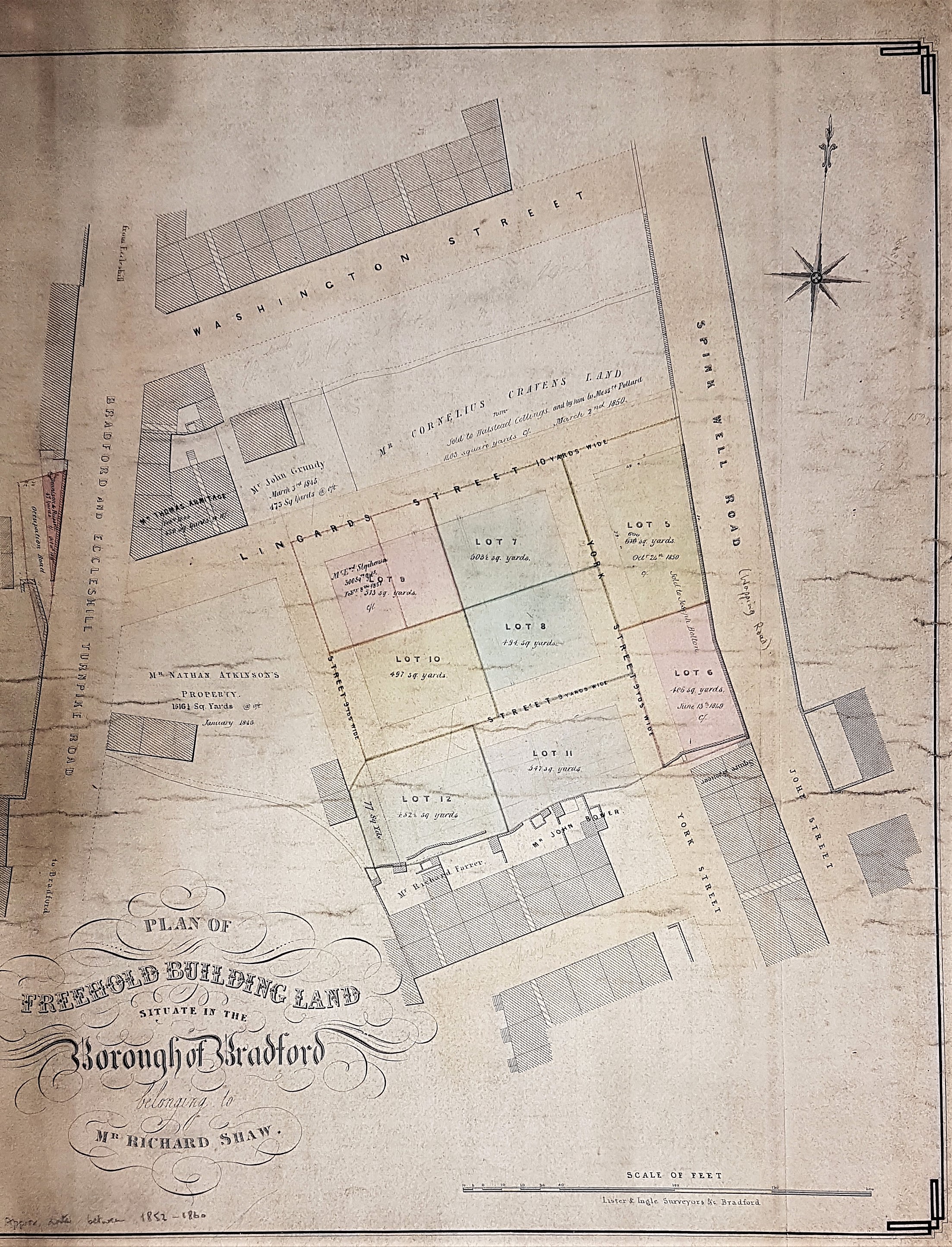
Title: Plan of Freehold building land situate in the Borough of Bradford, belonging to Richard Shaw
Size: 20” * 18” Material: paper
Scale: 30’ to 1” Condition: Good
This is a Lister & Ingle sale plan which provokes the usual questions of where and when? Spinkwell Road soon became known as Wapping Road, although ‘Spinkwell’ was retained for the name of the famous sandstone quarry a little further north along Wapping Road. Unusually a date may have been provided for this map since an unknown predecessor of mine has hand-written ‘1852-1860’ under the title: ‘Freehold building land, situate in the Borough of Bradford, belonging to Mr Richard Shaw’. The fact that Bradford is described as a ‘borough’ certainly places the map after 1847 in date.
Where are we? If Lingard Street is correctly identified then this thoroughfare once connected Wapping Road to Bolton Road, and is present on the 1893 25” OS map. Washington Street, on this plan, is in the position of Irving Street on the 1893 OS map. The street grid south of Lingard Street on the plan is only approximately correct, and the streets have different names. In the much earlier 1852 6” OS map Washington Street is in existence, and there is an empty space where our sale plan would fit nicely. But the Lingard Street on our plan is called York Street: this name is also present on our map, but the street provided with it is running in a different direction.
Where would we be today? Well, Wapping Street and Bolton Road survive but there has been wholesale demolition, and the Shipley-Airedale Road has been pushed through between them. Fortunately, a stub of Lingard Street remains. Walk up Bolton Road from the Corn Dolly (Cross Sun Street) and it is the second right turn along after Captain Street. I don’t think there’s any doubt that the location of our plan has been fixed correctly but I imagine that if Mr Richard Shaw was summoned back from Valhalla he wouldn’t recognise his property today.
I imagine that my predecessor gave 1852 as the earliest possible date for the plan because the development is not on the OS map published in that year, and must therefore post-date it. Can we firm up this date from consideration of the various landowners’ names? The only one I recognise is Nathan Atkinson. I assume he is the Nathan Atkinson, the ‘milkman of Bolton’, who hit the jackpot in 1854 and inherited the vast Jowett Clockhouse Estate – at the price of a long and expensive legal action (the Clockhouse Case), and the change of his name to Nathan Atkinson Jowett.
Another landowner, Cornelius Craven, has an unusual name. Very plausibly he is on the Bolton Road Electoral register for 1848, and seemingly died in 1850. One oddity is that in the 1841 census he is recorded as a cart driver, nearby in Wharf Street. That doesn’t sound like a property owner’s calling, but perhaps he too came up in the world. Naturally, since it is a commoner name, I have more difficulty with Richard Shaw. In the 1841 census there is a Richard Shaw of Millbank, butcher. On our plan neither the death of Cornelius Craven nor the elevation of Nathan Atkinson seems to have occurred so I shall suggest 1850 as its approximate date.
