X32 DEN c.1830 PLA
Size: 21” * 25”
Material: paper
Date: unk Scale: 2 chains to 1”
Condition: good
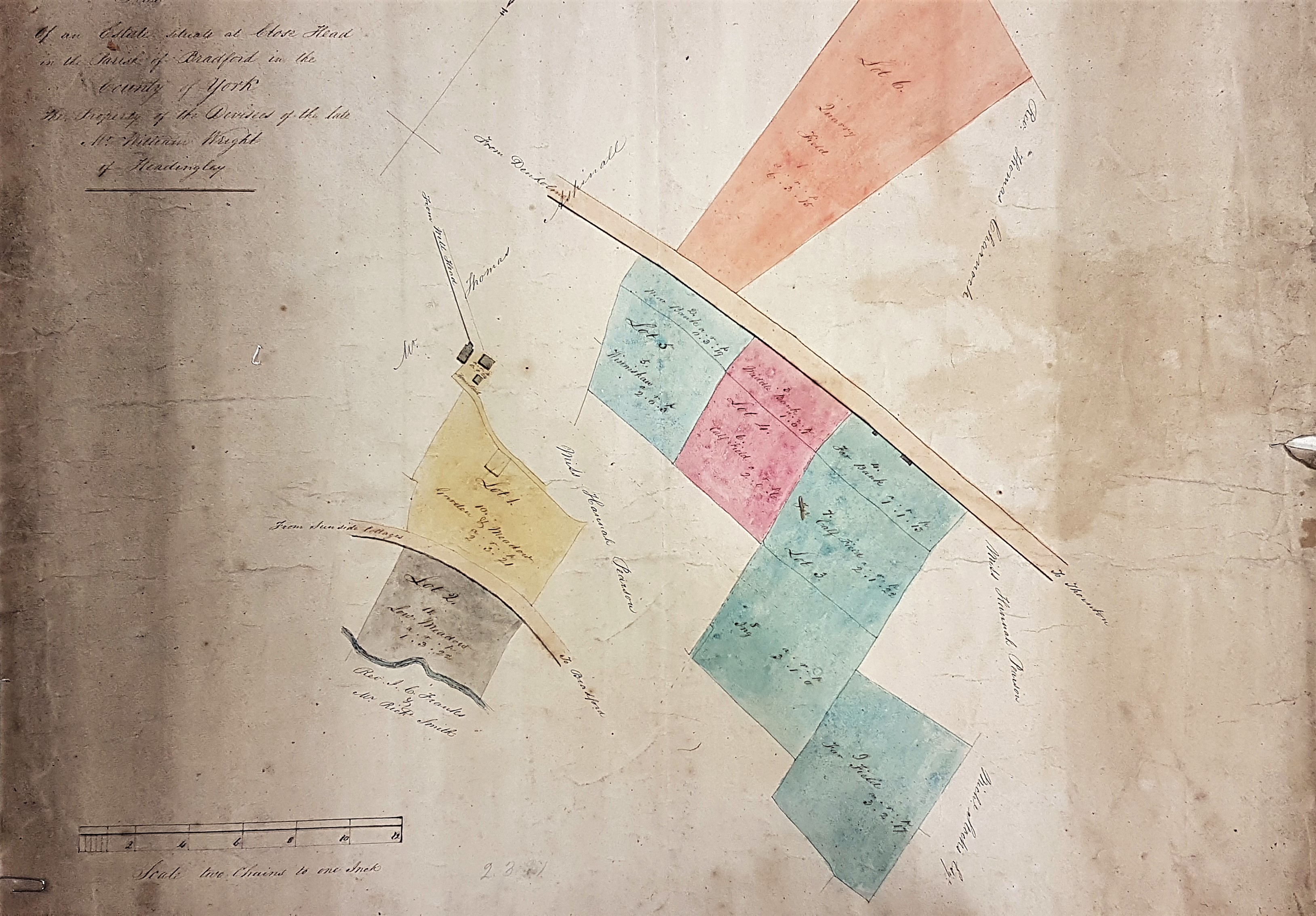
This beautiful, tinted, map is another plan from the Thornton – Denholme area. It is undated but stylistically it would fit the late 18th or early 19th century I would imagine. It is beautifully labelled in copperplate script. The rubric reads: ‘Plan of an estate situate at Close Head, in the parish of Bradford in the County of York, property of devisees of the late William Wright of Headingly’. A devisee is a person to whom something, especially real estate, is left by the terms of a will.
Unfortunately, William Wright is by no means a unique name, even though we know he lived in Headingley at the time of his death. In Low Lane, in nearby Horsforth, there are the remains of a Grade II listed corn mill which the listing document describes as: ‘built between 1772 and 1787 by William Wright’. This could be our man, but that is really supposition. Without a date or birth of death I doubt if I can take the identification any further.
So, where are we? Close Head is a recognised district of Thornton in the first Ordnance Survey map (1852) it is the high ground above the Bradford & Thornton Trust turnpike, to the west of the township of Thornton itself. Well Head still exists as a place name within Close Head. If I am correct the blue watercourse marked is the Pinch Beck. The road above this marked Sunside Cottages to Bradford is in fact the Bradford & Thornton turnpike. Why this is labelled Sunside Cottages – Bradford, I am uncertain. I cannot find Sunside Cottages on the OS map. To continue, there is a fragment of road with some cottages, which would be the ‘Bottom of the Row’ from the OS map. Above this, and various portions of the estate, is a second road which must be ‘Close Head Lane’. Lot 6, the ‘Quarry Field’, would then be the Thornton Heights Delf. A good guide to placement is field boundaries and field shapes, which do seem to fit my analysis.
As usual the owners of lands adjacent to the estate in question are included on the plan. Examples which we might hope to identify are Miss Hannah Pearson, Thomas Aspinall, Rev. Thomas Charnock and Rev. JC Franks. Now there are difficulties, which I will illustrate with the two clerks in Holy Orders.
I have heard that a Rev. Thomas Charnock was a friend of Patrick Bronte. The best bet may be a 65 year old man of independent means who at the 1841 census lived in Mill Cottage, Thornton. But I can also identify a Thomas Charnock in Ovenden in 1802, in Howarth in 1807, and a Thomas Brooksbank Charnock in nearby Cullingworth on the 1845 Electoral Register. Is this one person, and does that person have any relationship with the landowner on the map? In none of these cases is the title ‘Reverend’ employed.
The name Rev. Franks has appeared before in the Local Studies Library Reserve Collection maps. There is a plan of Kipping in the 1860s entitled ‘plan of projected Upper Kipping Estate, property of Rev James Clark Franks MA’. I made a note then that Rev. Franks (1793 – 1867) was the Vicar of Huddersfield but that he clearly owned properties in this area, possibly through his wife who was born in Kipping. James Clark Franks, then incumbent of Sowerby Bridge, married an Elizabeth Firth in 1824 at St Peter’s Church, Bradford. He had been a fellow at Trinity College Cambridge and seems to have been quite a distinguished scholar. If this is indeed the man than the map must date the 1820s at the very earliest, and probably later.
I would welcome the views of a reader familiar with the area or the personalities.

