X30 PLA c.1845 RAI
Size: 12” * 74” inches
Material: paper
Date: unk Scale: unk
Condition: good
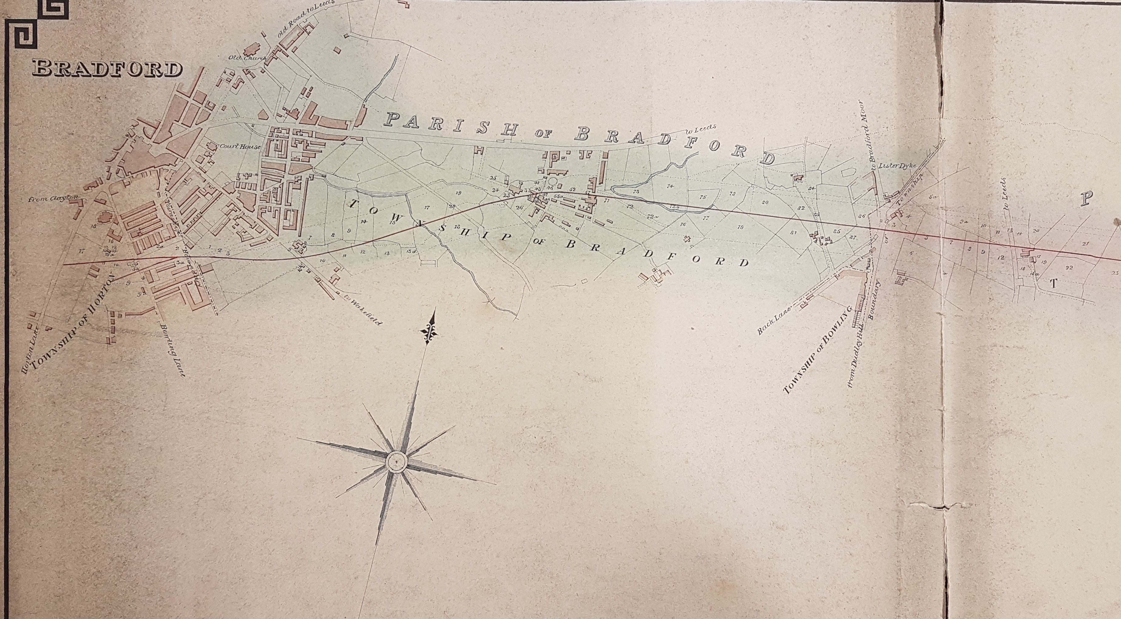
This very long map plots the whole of a proposed track between the two boroughs. At present I am only putting the Bradford section on-line which includes the location of a previous plan – ‘Property between Hall Ings and Dead Lane (1834-1850)’. This map is undated, nor is the railway company involved named anywhere. Before speculating further, it may be worth reviewing the history of Bradford’s rail links. In the 19th century there were several railway companies who were fiercely competitive. When a route from Leeds to Bradford was initially surveyed a route via Shipley required the least engineering. The Leeds & Bradford Railway was formed in 1843 and opened ‘Bradford Station’ in 1846 when the line first became operational. Its name was changed to Midland Station when Midland Railway Co. took over the line in 1851. The station was later known as Bradford Market Street by 1890, and was finally renamed Bradford Forster Square. A straight line from Halifax to Bradford via Low Moor was built by the Lancashire and Yorkshire Railway into Drake Street station (1850). This terminus was later called Exchange Station. L&Y subsequently became part of Great Northern Railway.
A more direct route from Leeds to Bradford was eventually constructed in 1854 and terminated at Adolphus Street Station, south of Leeds Road. Passengers had quite a long walk west into the town centre so this route was never really popular. Trains from Halifax often wanted to bypass Bradford and in 1854 the GNR Laisterdyke – Bowling Junction line opened for Leeds – Halifax direct trains. In 1867 Drake Street was enlarged to become a shared L&Y/GNR station called Bradford Exchange, and a loop line was opened to allow GNR trains from Leeds direct access into Bradford Exchange, which is still used today. Adolphus Street Station became ‘goods only’ at this time. Much later Exchange Station evolved into the Bradford Interchange. The main problem with Bradford’s rail services is that no link line was ever constructed to join the two main stations, so that even today there is no ‘passing traffic’ through Bradford.
The first thing obvious on this map is that the proposed line crosses Wakefield Road well south of the site of the proposed Drake Street station (at Goodmans End) and appears to end in Horton, south of the (unnamed) St John’s Church, between Horton Lane and Manchester Road. The map is undated but must predate the construction of Drake Street Station in 1850 but be later than the Bradford Court House in Hall Ings and St John’s Church (c.1840).
When the Leeds to Bradford line was finally constructed it didn’t follow this track. Adolphus Street station was constructed where the ‘TOW’ of township is printed and the actual line took a more southerly course which didn’t involve any demolition in New Leeds. By the time it got to Lister Dyke (Laisterdyke) the actual line was further north and involved the construction of a station.
The purpose of the map is unknown. I suppose one possibility is that it was produced by the Leeds & Bradford Railway before a route through Shipley was decided upon, or by GNR before the construction of Adolphus Street. Unfortunately I really don’t know sufficient railway history to be able to do more than guess.
