
X 19 SHE c.1850, PLA
‘Plan of the Township of Shelf’
Size: 28” * 24”
Material: Paper Scale: unknown
Condition: good
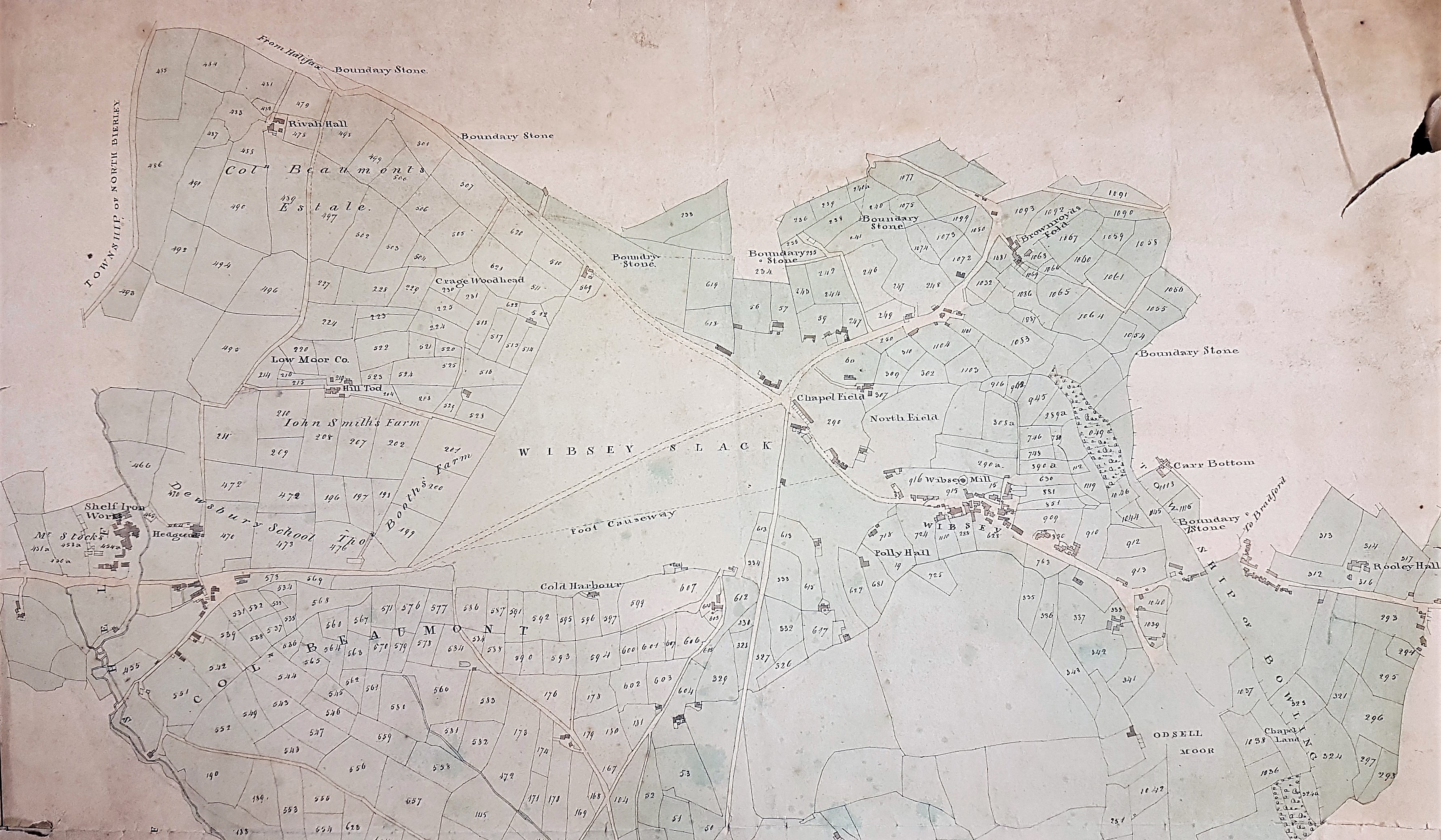
This detailed map is only marked ‘Plan of the Township of Shelf’ with no explicit comment about its age and purpose. I’ve given it a provisional mid-19th century date but this is mere guess work until such time as more detailed study is possible. It is a little hard to believe that this lovely map is not a copy of one already in the permanent collection, but with Covid restrictions I’ve no way of checking this at present. In 1828 or 1829 surveyor Joseph Fox drew up a similar map recording the property of the Low Moor Iron Company, although that map is entitled ‘North Bierley’. I should add, for the benefit of readers who don’t know this region, that the Low Moor and Bowling Iron Companies smelted iron ore, obtained locally from the roof of the Black Bed coal seam, using coke made from the deeper Better Bed seam. The production of cast iron and ‘best Yorkshire wrought iron’ was extremely profitable for more than a century. The West Yorkshire Archives (Bradford) have a copy of the Fox map, generously donated by Geoff and Mary Twentyman. The donors suggested that it was kept on display at the Low Moor ironworks, and it has certainly been annotated at a later date. With maps, other than those of the Ordnance Survey or specially surveyed town plans, it was common to redraw an older plan with additions. With maps from this general area I do usually ask the advice of Mary Twentyman who is a noted local historian with a special interest in Low Moor.
As far as this present map is concerned Mary has seen photocopies of a quite similar map from 1811 prepared by George Leather, and because of her detailed local knowledge she has been able to make many useful observations. She notes that what is now called Old Hanna Wood in Judy Woods is named here as ‘Neddy Wood’. She speculated that the name might refer to Edward Rookes/Leedes but the 1811 Leather map is the only place where she had seen the wood with this name. (She has found a reference in some notes at York Minster Library to a teenaged Edward Leedes being referred to as Neddy Rookes). Evidence that whoever prepared the map has definitely copied from another is provided by the fact that some of the other names are wrongly transcribed: Polly Hall instead Folly Hall, Grage Woodhead instead of Grace Woodhead, and Hill Tod instead of Hill Top. There are other mistakes too, most noticeably the words Willin Hall and Wm Hall at the bottom where there is a crease in another copy. She is not sure about the significance of the green wash applied to the map. It could be where the Low Moor Iron Company had mineral rights/leases, or speculation over where it could get them. Even the title is wrong – ‘the Township of Shelf’ seems to be in a different hand.
You can see that the place name ‘Glass House’ is very clear on this map. This represents the site once occupied by Bradford’s only known glass-making furnace. The builder of the glass-works, known to be in existence by 1748, was again Edward Rookes Leeds (1715-1788) of Royds Hall, Lord of the Manor of Wibsey. In that era the space needed for a furnace, and its attendant glass-workers, was enclosed by a brick cone, and there were large underground flues. An excellent surviving example of such a cone can still be seen at Catcliffe, South Yorkshire. The Fox map in the WY Archives places a large circle at this site which could easily represent a glass cone in plan, but the map illustrated here has no such feature. The fate of the glass works was actively researched by Mary Twentyman and myself and ‘Glass House’ long remained as a place name in Low Moor. It provides a timely reminder that with this series of on-line maps I am only scratching at the surface of the long and complex history of the City of Bradford, and even to do this much I need, and receive, a good deal of support.


