Title: Bingley, Green Hill & Micklethwaite
Paper
Undated
Scale: unknown
Condition: Good
Comments:
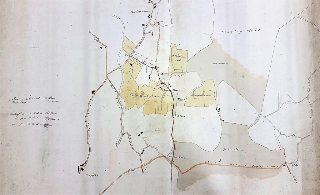
Very little information is recorded about this map. It is undated and although it records an estate there is no indication of the use to which it was put. Here the limitations imposed by my ignorance of Bingley history are severe, and I am hoping that a reader will be able to improve my interpretation.
Central to the map is evidently Green Hill, Bingley. It, and the adjacent fields, are the property of ‘Mr Hodgson’. An estate sale plan is perhaps the most plausible function of the map. What about the date? Green Hill and Green Hill Hall resemble the arrangements shown on the 1852 OS map, but with fewer buildings. This map may well be older than 1852 then. Another indication of an early date is given by the ‘open moorland’ east of Green Hall. By the time of the OS map these are enclosed fields. This fact suggests our map is earlier than the operation of the Enclosure Act in this area, which I believe was in 1816. Finally, it must be remembered that an old map can be reused, many years after its first publication, for an entirely different purpose.

If you start at Green Hill then moving west brings you to Stye Lane, which is spelled Sty on the OS map. Both our map and the OS show the Leeds-Liverpool canal where it meets Micklethwaite Lane. This section of the canal was completed in the 1770s so at least our map cannot be older than that! Oddly our map shows nothing of the limekilns, the remains of which are still present at the crossing site, although they are well displayed on the first OS map. I’ve assumed that they were created at the time that the canal was being constructed, but that may not be correct. Another possibility is that they were of no interest to the surveyor of the estate plan, and were simply omitted.
Green Hill Hall and Cottage are grade II listed buildings. Who is the landowner involved? The Bradford Observer records a sale of books and furniture at Green Hill in July 1855, but this did not seemingly include estate land, and in any case was very late for the presumed date of the map. In the mid-nineteenth century (1851 census) there was a solicitor, Richard Huddleston Hodgson, living at Main Street, Bingley who was son of Thomas Hodgson a lime merchant. I wouldn’t have thought that a lime merchant and his son would have been affluent enough to have a considerable estate, and again their dates are perhaps a little late.
Harry Speight in his Chronicles of Old Bingley states that in the early nineteenth century the owner of Green Hill was Sarah Murgatroyd. Lacking heirs the Greenhill property was eventually bequeathed to a relative, Mercy Carter. Mercy Carter had became the wife of Richard Hodgson, of Keighley in 1802. This event links the Hodgson surname with Green Hill. Mercy died in 1836. Speight goes on to say that ‘Mr. and Mrs. Hodgson left Greenhill about 1880’, but gives no first names relating to this later generation. Unless someone can help me the best I can say is that the designation ‘Mr Hodgson’s Estate’ could fit most of the middle section of the century, say 1836-1880. Rishworth is a distinguished Bingley surname so it is not surprising that we can also read ‘Mr Rishworth’s land’. But Thomas Rishworth died at Thwaites House in 1809, aged 70. Could the map be as early as this?

I believe this map was for the creation of a link road between Crossflatts and Park Road ( A-D). This explains why today the road to Greenhill Gate (B on the map) from Micklethwaite Lane is called ‘Stye Lane’ ( where the bad corner is ) and the rest upwards is named ‘Greenhill Lane’.
Style lane originally connected Micklethwaite Lane to Greenhill Gate only (B).
B-C became Greenhill Lane which then connected with Lady Lane ( Lady house ). Prior to this Lady Lane ran down past Greenhill Hall and onto Bridle Road at Peaseacre, Micklethwaite presumably as drovers track beyond B. There doesn’t appear to be a continuation of Lady Lane to Walsh Lane as there is today.
Interestingly, this probably was to replace the road that went along the canal called ‘High Road’ ( today’s Canal Rd, Crossflatts) and then onto Beck Lane. This might explain why the canalpath is so wide between these points. I would appreciate if anyone finds a date for the map.
LikeLike