X13 ECC c.1825 PLA
Plan of the Eccleshill and Bradford Turnpike Road c.1825
Size: 58” * 21”
Material: Paper
Scale: unk
Condition: Good
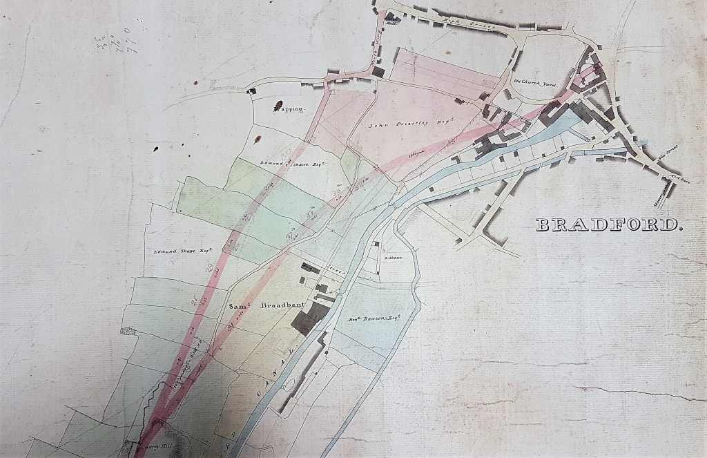
This map is undated but the well-known Benjamin Rawson (1758-1844) is quite clearly indicated as a landowner. He was a wealthy businessman who purchased the Lordship of the Manor of Bradford, a role in which he and his two daughters, Miss Mary and Miss Elizabeth Rawson, will be familiar to local historians. The map clearly must date from before 1844, the year that he died. Samuel Broadbent, whose name you will also see, was a Bradford vitriol maker. The two men were linked by the North Brook Vitriol Works which was situated between Wharf Street and Canal Road. Vitriol (sulphuric acid) and aqua fortis (nitric acid) were first made there by Benjamin Rawson. He is believed to have been in operation by 1792, which makes the works one of Britain’s first chemical plants. In this, and much else subsequently, Bradford was ahead of the game. In 1838 Rawson sold the works to Samuel Broadbent, who lived in Northbrook House where his garden led to the canal.

The Old Church Yard is drawn on the map, but curiously not St Peter’s itself. The Bradford Beck, Canal basin and the canal itself are easily visible. You can see the name John Priestley. I believe this was ‘Captain’ John Priestley (1776-1832) who served in the Bradford militia and was the son of Joseph Priestley, instigator of the Bradford Cabal and for many years was the canal engineer, a most important post. If I have the right man John’s date of death is another clue to the date of the map.
You might like to try fitting other mapped features such as Paper Hall, North Wing and Wapping into a modern map. The main feature, in red, is the Eccleshill & Bradford Turnpike Road the lower portion of which evolved into Bolton Road. The upper portion became Wapping Road. The two roads united at Spinkwell Quarry which is described in the plan as Quarry Hill. The geography of this area has changed so much that cannot say of routes follow exactly this course but they must be at least approximately correct. The Eccleshill & Bradford turnpike opened in 1826 having been designed by Joseph Smith. Joseph’s son, George Belk Smith, was equally well-known and acted for Sir Titus Salt as a land agent.
If you follow the course of the turnpike past Quarry Hill you will see the name of Rev.G(odfrey) Wright as a landowner (he features regularly in this series) and then past various quarries (Boar Well and Cliff Wood) to Bolton Fold. Finally, it reaches the land of William Rawson who I don’t think was directly related to Benjamin Rawson. The obvious meaning of the map is that it was surveyed to show the course of the turnpike road prior to its construction in order to show how property along the route would be affected. This would suggest a date of 1820-25 but I’m surprised on stylistic grounds that it is as early as this.

