My number: X 09 H Index: MAN c.1851 PLA
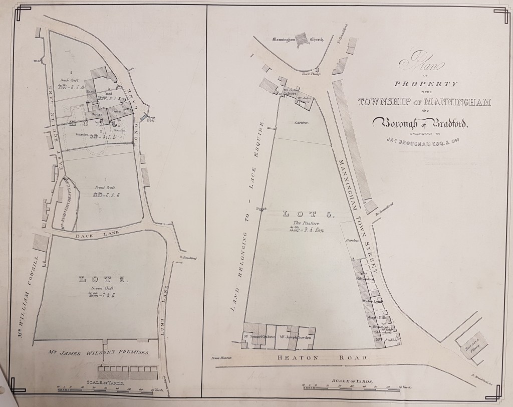
Plan of property in the township of Manningham
Size: 19” * 23”
Material: Paper
Scale: 20 yards : 1”
Condition: good
This sale plan of The Pasture (lot 5 on this plan) resembles a map already displayed, X05, but the present plan is more detailed, and shows an additional piece of Manningham estate. It is undated, but St Paul’s Church (constructed 1847-48) is clearly marked. The year 1847 was the date in which Manningham was incorporated into the new Borough of Bradford and I imagine that the plan was drawn up soon after. The later Victorian terraced housing, now present in this location, is of course unbuilt. The Pasture, on the Manningham Tithe map, is somewhat over 2 acres in area. The vendors are trustees acting for the late James Brougham (Mary Brougham, Rev. Thomas Austin and Ann Idle). Cudworth records that these trustees sold much of the estate to Sir Titus Salt and Henry Forbes in 1851, so this is the date I have taken for the plan.
With the help of Cudworth it is possible to work out the history of these plots. They are part of the land belonging to the well-known Northrop family. The last male member, William Northrop, died in 1800, aged 63. His daughter Mary Northrop had married James Brougham. On the death of her mother in 1820 Mary and her sister Ann Northrop, who had married John Idle, inherited. I assume their respective husbands initially benefitted but both were outlived by their wives.

So where are we exactly? The general view is easily seen in a detail of the first OS map of the area (published 1852). The two plots in our plan are at the points occupied by ‘G’ and ‘H’. The real orientation of The Pasture is W-E. Manningham Town Street is now called Church Street: Heaton Road retains its name. Their junction is a couple of hundred yards from Toller Lane. The first section of our plan is in the correct N-S orientation. The section of ‘Tong Lane’ drawn is now the other end of Church Street but East Squire Lane retains its name. I assume that Back Lane is incorporated into Carlisle Road but there was Victorian terrace construction throughout the entire area which may have disrupted the pre-existing road network. Manningham is starting to emerge from a rural past: lot 4 is clearly a farmhouse.
One of the fascinating aspects of such sale plans is the snapshot they provide of local owners and occupiers. For a family historian this plan would fit well with the 1851 census reports. So, in a large font, we have landowners James Wilson, William Cowgill, Joshua Patchett, and (F J) Lace Esq. In a smaller font we have cottagers and occupiers. James Wilson may be a company name. When James Wilson died on 15th April 1867 the Bradford Observer describes him as ‘the senior partner of the old and respected firm of James Wilson & Sons, joiners and builders, White Abbey.’ I know that the firm did a good deal of construction work in Manningham and the speculative nature of some of it led to its bankruptcy in the 1890s.
