
7.004 BRA 1849 REG
REGINA v MIDLAND RAILWAY showing Midland Rail Station & Canal Basin
Paper Scale: 30 yards = 1 inch Size: 65*50 cm Condition: Fair
Bradford merchants took a leading role in promoting the Leeds-Liverpool Canal in the late eighteenth century. This had a connecting spur to Bradford with a canal basin near the town centre. The development of the waterway, the first section of which (Skipton to Shipley and Bradford) was open by 1774, greatly aided the export of coal from Bradford’s mines. An important import was lime from the quarries at Skipton: this was needed for mortar, iron smelting, and agriculture. Canal-side limekilns were developed to calcine the limestone to quick lime.
The first map is detail from a very clear litigation plan showing the canal basin, a crucial area of contemporary Bradford. Presumably an existing map has been annotated as evidence in litigation. The Leeds & Bradford Railway is part of the Midland Railway Co. and the terminus is name has been changed to Dunkirk Street Station. The station site has been developed more than once and is now represented by Forster Square Station. As you can see it is very close to the canal basin and the attendant warehouses. To the right of the map is the Well Street Coal Staithe. At an earlier period this was supplied with coal by the Low Moor Iron Company. I don’t know if it had a different owner in 1849 nor how coal supplies were brought to the site. The whole area is well-developed and there are several neighbourhood textile mills. Litigation involving detailed maps often involved compulsory purchase or the compensation for such purchases, but if so here I cannot see how the crown, Regina, would be involved. It is annotated by a Borough Surveyor, Charles Gott, which must place it after 1847 and I think of him as being active in the late 1850s. He is known for designing Scholemoor Cemetery. Here is another section of the map:

It is possible to compare this map with two others in the collection at 20-25 year intervals. Map 10.005 (BRA c1820 CAN) is described as ‘Thornton & others against Pollard’ and evidently arises from another Canal Basin legal dispute which took place around 1820. It is labelled as the Defendant’s plan. It is undated but use and ownership dates added to the map are between 1791 & 1819. Its value lies in very precise surveying of land and property between Spinkwell Lock and the Canal Basin about 30 years before first Ordnance Survey map. Naturally there are no railway tracks. The basin looks very close to the churchyard although on the ground there is a substantial gradient between the two locations.
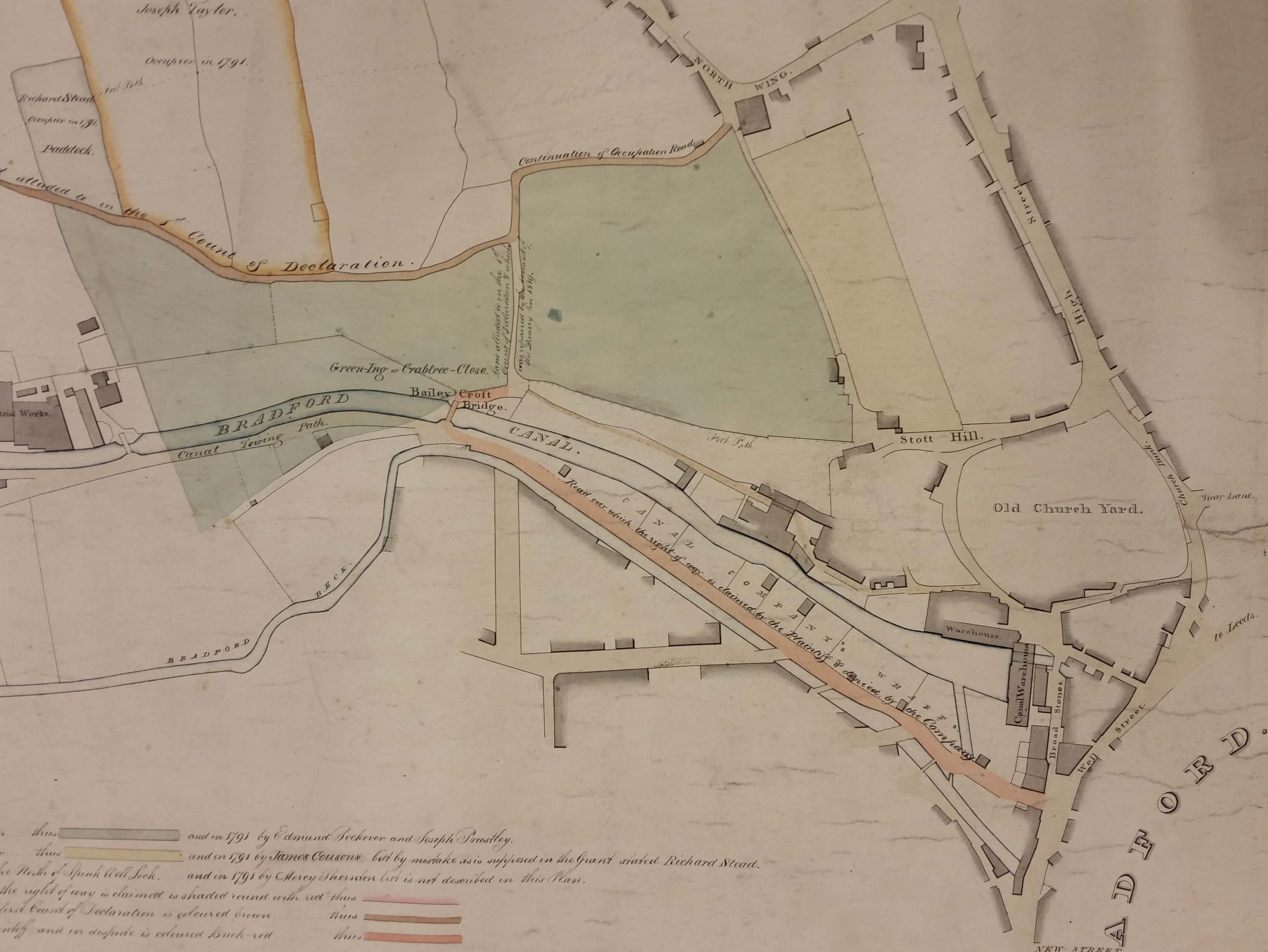
Finally we have the same area taken from the 1802 map of Bradford. Note how the Bradford Beck originally meandered. It has been substantially straightened and culverted over the last 200 years.

Since this account was first posted I am grateful, not for the first time, to photographer and local historian Kieran Wilkinson for correcting a mistake I made. The Bradford Canal Basin plan, which I originally described as being from 1849, is actually from 1864. Kieran explained that the purpose of it was to show the positioning of Commercial Street prior to 1849 (as it says at the top of the plan). Litigation was brought by the Corporation over whether Commercial Street remained a public highway after the Midland Station had been built, or not. The Midland Railway Company maintained that it was their private property. The Corporation claimed that it was a public highway.
The reason Dunkirk Street is shown on the plan is because part of the Corporation’s case was that the Midland Railway Company were legally obliged to provide an alternative route to Dunkirk Street and Dodgson Hill and that the redeveloped Commercial Street provided that alternative. The rubric ‘Dunkirk Street Station’, rather than being a marker to name the station, is actually pink shading to overlay what had been Dunkirk Street and Dodgson Hill over which the station was subsequently built.
The Corporation won and it was held that Commercial Street was a public highway. Many thank Kieran.
