
3.036 BRA c1866 DIX BHM 784 B11
Tracing paper Scale:10 yards per inch Size:58*51 cm Condition: fair
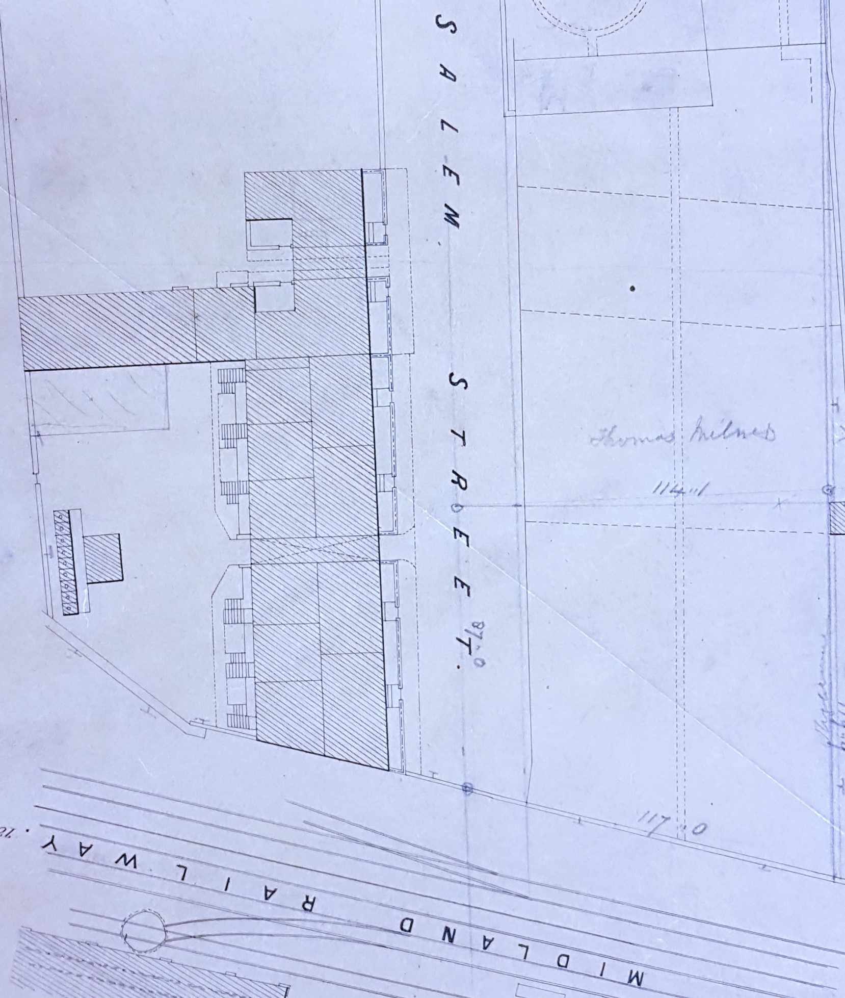
This plan was drawn up by Dixon & Hart, surveyors. It shows the lower part of Salem Street, off Manor Row. This is one of a collection of short streets leading towards the railway lines after the late 1840s: Broad Street, Stone Street, Salem Street and Grammar School Street. The plan is annotated in pencil, presumably by an earlier student of maps, ‘c.1864-68’. This may be too late a date since the census returns for 1861 seem to show more residents in Salem Street than might be expected from the plan itself.
The origin of the street name is easily explained by the first Ordnance Survey map of the area (published 1852). The Salem Independent Chapel (Manor Row) was placed there, although the road itself is not named. It would seem that originally the entrance to Salem Street from Manor Row was framed by the Leeds & Liverpool Canal offices (upper) and the classically inspired Salem Chapel (lower). These beautiful stone buildings are still present today, although their functions have naturally changed. They are not present on the above plan since it shows the lower part of Salem Street, approximately from Hallgate Road (which didn’t then exist) to the Midland Railway lines.
On the right-hand side of Salem Street, in both the plan and the 1852 OS map, is terraced housing which features, somewhat extended, in the OS map of the 1890s. You may just be able to discern a row of closets belonging to these properties. The houses were seemingly truncated in the later nineteenth century when the land occupied by the Midland Railway was extended, and have subsequently been swept away. The interest lies more on the left-hand side. The open space is annotated in pencil ‘Thomas Milner’ who is presumably the vendor, purchaser or occupant of at least one of the plots. There was a grocer and tea dealer of this name by 1850 known to have a house in Salem Street and premises in Wall Street & Ivegate.
A short terrace of town houses must have been erected on the plots indicated soon after the plan was drawn up since they remain today. What I found most challenging is trying to establish the function of the buildings adjacent to the space they were to occupy. There is also what appears to be an annular path and central garden feature. In the detailed 25 inch OS map of 1889 more terraced housing has been constructed but what was going on 30 years earlier? We know quite a lot about Victorian Salem Street from small adverts in the Bradford Observer and in contemporary trade directories.
The Freemasons’ Rooms were situated there in which the English Church Union held its annual meetings. In 1850 Rev JG Miall was the minister at Salem Chapel. His first name was James and in the 1841 census he was living in Brunswick Place. Among his children was Louis C Miall and in due course a schoolmaster called LC Miall gave lectures on botany at the Freemasons’ Rooms. It appears that there was also a Gymnastic Club there. In an 1861 directory we get a complete list of inhabitants of the Street confirming that there were slightly more than 30 households. The odd numbered houses seem slightly more affluent and their occupants are: woolstaplers, wine merchant, merchants and drysalters. The even numbered houses are more likely to be occupied by tradesmen.
Since the only name on the plan is Thomas Milner (1822-1899) I have looked at him in a little more detail. He was born in Armley, Leeds and married Mary Green in 1849 at St Peters Church, both being literate. His father in law is described on the certificate as a ‘gentleman’ but both Thomas, and his father of the same name, were grocers. I can identify the newly married couple living at 41 Salem Street. By 1861 they had daughters: Ruth, Martha, Mary and Sarah and they were to have three sons after this time. Thomas identifies himself as a grocer and tea dealer and shares his house with various assistants and apprentices. In 1881 he is still alive and a grocer living at 23 Springfield Place and by 1891 a tea merchant of Aireville Place Heaton. He died in 1899 in Heysham, Lancashire. This is a pleasant spot near Morecambe and might have been chosen as suitable for retirement.
In conclusion I have wondered how much of the history of this location can be deduced from the study of other old Bradford plans. In the 1802 map the future Salem Street and its surroundings is a green field site with no buildings or roads from Skinner Lane (the embryo Manor Lane) to the canal and Bradford Beck. By 1834 Skinner Lane has become Manor Place. School Street is named and contains buildings and a truncated Grammar School Street is also present. Even then the space between these two roadways, including the future site of Salem Street, does not appear to have been built on. Within 15 years, as illustrated by the 1849 map, we have Manor Row: also Broad Street, Stone Street, and Salem Street. The Congregational Salem Independent Chapel (1836) and the Leeds & Liverpool Canal offices (1840) have both been constructed, and there is now a railway line from Bradford to Shipley (1846). The Apkin map of 1854 shows terraced housing along School Street, Broad Street and Stone Street. No other building has taken place in Salem Street aside from the chapel and canal offices. By the time of the 1861 Bradford town plan the constructions illustrated in the initial plan are in existence but little has changed by 1876 although further buildings are present by the late 1880s. I assume the Canal Offices functioned until the canal closed in the 1920s. I’m not sure at what stage Salem Chapel ceased its function but I gather the building was used as a School Health clinic for many years.
