
3.040 ALL 1876 PLA BHM 723 B11
Paper Scale: 30 feet per inch Size: 62*50 cm Condition: fair
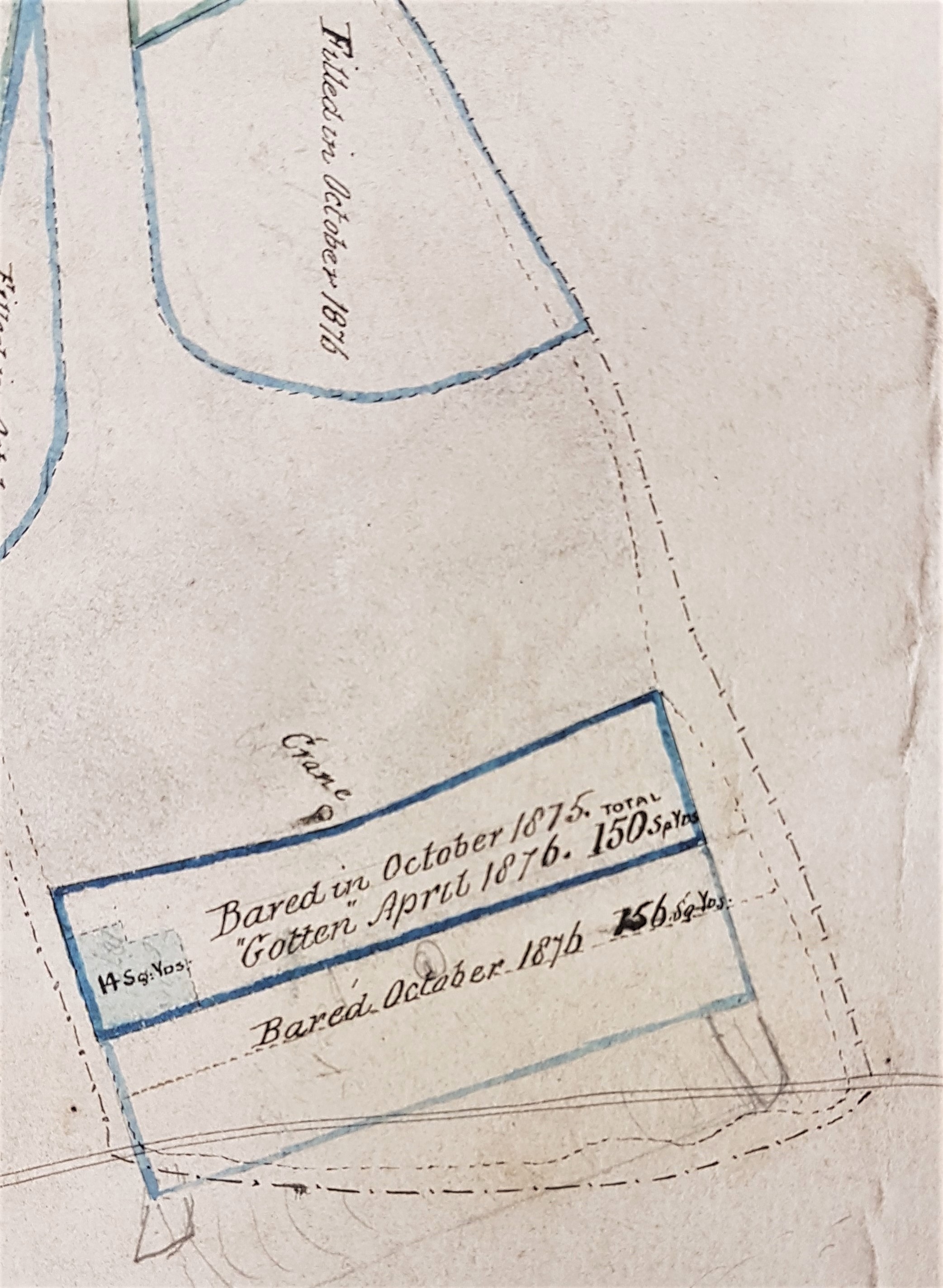
This rather dusty plan is annotated, on the back, Allerton Grange Quarry (Open). It is a favourite of mine which I have already used for the Local Studies Library blog. Stone quarries in Bradford often had fairly short lives but this one had evidently been working for two years at least. Some of the active sections of the quarry have dates attached: 1875-76. Note the position of a crane placed to handle the stone pieces. Cranes could be worked manually but a steam crane was purchased for the Allerton quarry of J. Farrar & son in 1865. The fact that this was worth reporting in the Bradford Observer probably indicates it was the first in the district.
Where was Allerton Grange quarry? There is an extraction track drawn which is leading to Grange Lane. This name is crossed out and ‘Dog Lane’ substituted in pencil. Dog Lane it remained until post-War housing development in Allerton. The quarry is marked as Upper Grange in the second Ordnance Survey map of the area (surveyed 1891). By 1905 a cricket pavilion seems to be sitting on the site and in the 1930s the area consists of fields again.
The plan itself contains no evidence of ownership. Nearby Allerton Grange Farm was on Atkinson-Jowett land. The owner and operators are not necessarily the same people of course. Contemporary trade directories list many stone merchants situated in Allerton any of whom could have been involved with this site. As well as J Farrar & Son other Allerton quarries of this period were operated by Wilkinson Patefield, Patefield & Greenwood, John Roper, D & C Roper, and Moulson & Geldard. What rock was exploited in Allerton? The local geological guides record Elland Flags being quarried there in common with much of north Bradford where on high ground it is conveniently near the surface. Elland Flags were sandstone strata consisted of several bands of varying thickness and quality which were located under the Better Bed coal seam, itself extensively mined in south Bradford.
Three technical terms are used on the plan: bared, gotten and filled. I assume that baring involved removal of the overburden of topsoil and non-commercial rock to expose a bank of the desirable material on which the quarrymen could work. At this date blasting powder was used to bring rock pieces down to the quarry floor. ‘Barers’ seem to be recognised as a sub-trade and are advertised for in the press under that name. Unfortunately taking quarry ‘barings’ seems to have a quite separate meaning which implies measuring the dimensions of an exposed stratum of stone to enable the royalties for the owner to be assessed. ‘Gotten’ must mean an area from which stone has been won or removed. ‘Filled’ must be a quarried area returned to the state specified in any lease. As far as I can see the intention was normally to return a site to agricultural use. The land-owner frequently imposed strict boundaries to the degree of exploitation allowed.
Valuable strata of stone could be mined as well as quarried. Shafts and ‘old shafts’ may be marked on plans, although not here. Quarries tend to be noticed in the press when accidents occur to the workers. Stone miners appear to form a high percentage of these.
