
4.013 MAN 1838 BOO BHM 1050 B13
Catherine Booth’s land in Manningham
Paper Scale: unk Size: 100*62 cm Condition: fair
It can be very difficult to orient yourself correctly when examining an old map. Map-makers often did not identify the direction of north and a convenient local building that would have provided an obvious fixed point, such as Bradford Parish Church or Manningham Mill, may not be included. The names of roadways are often not given, or if they are provided their names may differ from those used today. This beautifully drawn plan of Manningham, taken from the Bradford Local Studies Library reserve collection, exemplifies such difficulties.
The first image constitutes about half the original map which is helpfully annotated on the back: ‘late Miss Booth’s property, Manningham’. The question that naturally arises will be who is Miss Booth likely to have been? As so often William Cudworth provides the answer: ‘In one square house, which is still standing in Skinner Lane, (lived) Jonas Booth with his maiden sister Catherine. Booth was one of the old race of stuff-makers, his warehouse being in the rear of his house. He died in 1837 bequeathing his property to his sister, who died the following year.’ I’ve dated the map to 1838 after this last comment. I should explain that ‘stuff’ is woven worsted cloth. Since Jonas Booth was of ‘the old race’ his stuffs will have been woven on hand looms using tops derived from hand combed wool.
Many of the roads in this part of Manningham appear to have changed their names: this is often because an old trackway has been replaced by a new road which is on a different alignment, although still running in the same general direction. In this way, for example, Hesp Lane was succeeded by North Park Road. Then again there may be inconsistencies in spelling so that Hesp Lane may be called Esp Lane, as here, or Lily Croft Lane can sometimes be Law Croft Lane.
Neither of these possibilities explains why, starting at the left hand side of the map (west), the road labelled as Lilly Croft Lane is now called Heaton Road, from its junction with Church Street. This thoroughfare leads from Bradford to Heaton, as the map indicates, in a direction that is a few degrees west of due north. Today there is another Lilycroft Lane, which is an extension of Oak Lane leaving the now Heaton Road to the left of the map, at what I might call Manningham Mill corner. From comparison with the first Ordnance Survey map of the area, which was being surveyed about a decade later, the lower block of housing on the left is the short terrace called Lilly Croft and the upper block is a terrace, no longer existing, which was in front of the first Manningham Mill. This mill itself was rebuilt by Samuel Cunliffe Lister in 1873 after its predecessor was destroyed by a disastrous fire. The mill buildings themselves, which would have permitted instant positional recognition, are not drawn on this map.
Moving right (east) we cross property of ECL Kaye (Samuel Cunliffe Lister’s father) where the field patterns closely resemble those of the first OS map. To the right of the map we reach Skinner Lane in Manningham village which still in part possesses that name. It would appear that Jonas & Catherine Booth owned property on either side of Skinner Lane, but none of the blocks drawn here look exactly square as Cudworth’s comment would lead us to expect. Skinner Lane splits and the portion included on the map is now represented by Rosebery Road. Running parallel to the east, but not drawn here, is St Mary’s Road.
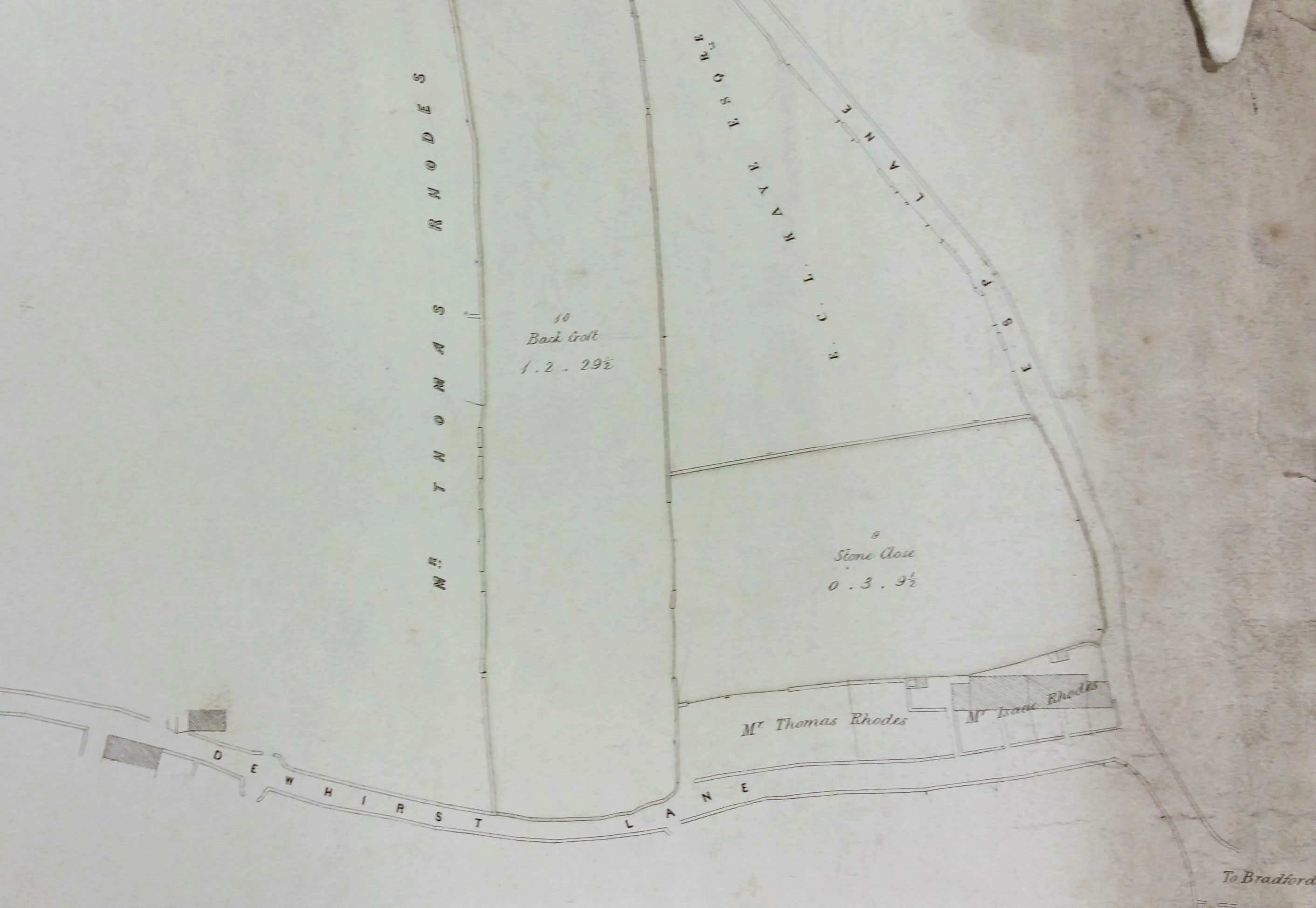
Both Rosebery Road and St Mary’s Road join the thoroughfare leaving the village to the east, and reappearing on the second detail, which is Dewhirst Lane (now called Oak Lane although I think you would struggle to find any oaks). Many readers will be familiar with the ancient, but sadly ruinous, ‘Old Manor House’ near the Rosebery Road – Oak Lane junction. An English Heritage historical and architectural survey of this building exists based on the work of noted local architectural historian Dr George Sheeran. It fairly conclusively identifies the Old Manor House as the Square House of Jonas & Catherine Booth. They were but two of a great many owners.
In the first OS map Dewhirst Lane is called Duce Lane. I assume that Dewhirst is formally correct but that ‘Duce’ was a contraction by which it was generally known. Again Cudworth writes:’ (Skinner Lane) was formerly the only outlet from Manningham to Duce Lane (now Oak Lane) which obtained its name from one Dewhirst (locally pronounced Duce) having long been resident there.’ Whatever its name the lane ends at property belonging to Thomas and Isaac Rhodes. Here is joins Esp Lane (otherwise Hesp Lane) which eventually evolved into North Park Road when the land surrounding Manningham Hall was developed as a public open space (Lister Park) after 1870. Here you may just be able to make out the words ‘to Bradford’, at the bottom right of the image, which is approximately the position of the beautiful Manningham Park gates. The road shown here links to Manningham Lane – Keighley Road, which is not drawn.
So, to conclude, who are Thomas and Isaac Rhodes? The surname is known in Heaton, Frizinghall and Manningham in the eighteenth century and earlier. In 1832 a farmer of the name of Thomas Rhodes is paying land tax in Manningham (as indeed are the executors of the late Mr. Booth). In the 1861 census a butcher and farmer called Isaac Rhodes (aged 56) is resident in Skinner Lane, Manningham. As late as 1870 John and Thomas Rhodes were Manningham butchers with an interest in Bradford Old Bank. I think we are probably looking at one extended family.
