3.033 BRA c1870 PLA BHM 812 B11
The creation of Midland Road and area between Manor Row and Valley Road
Material: paper Scale: 4 chains per inch Size: 78*28 cm
Condition: good
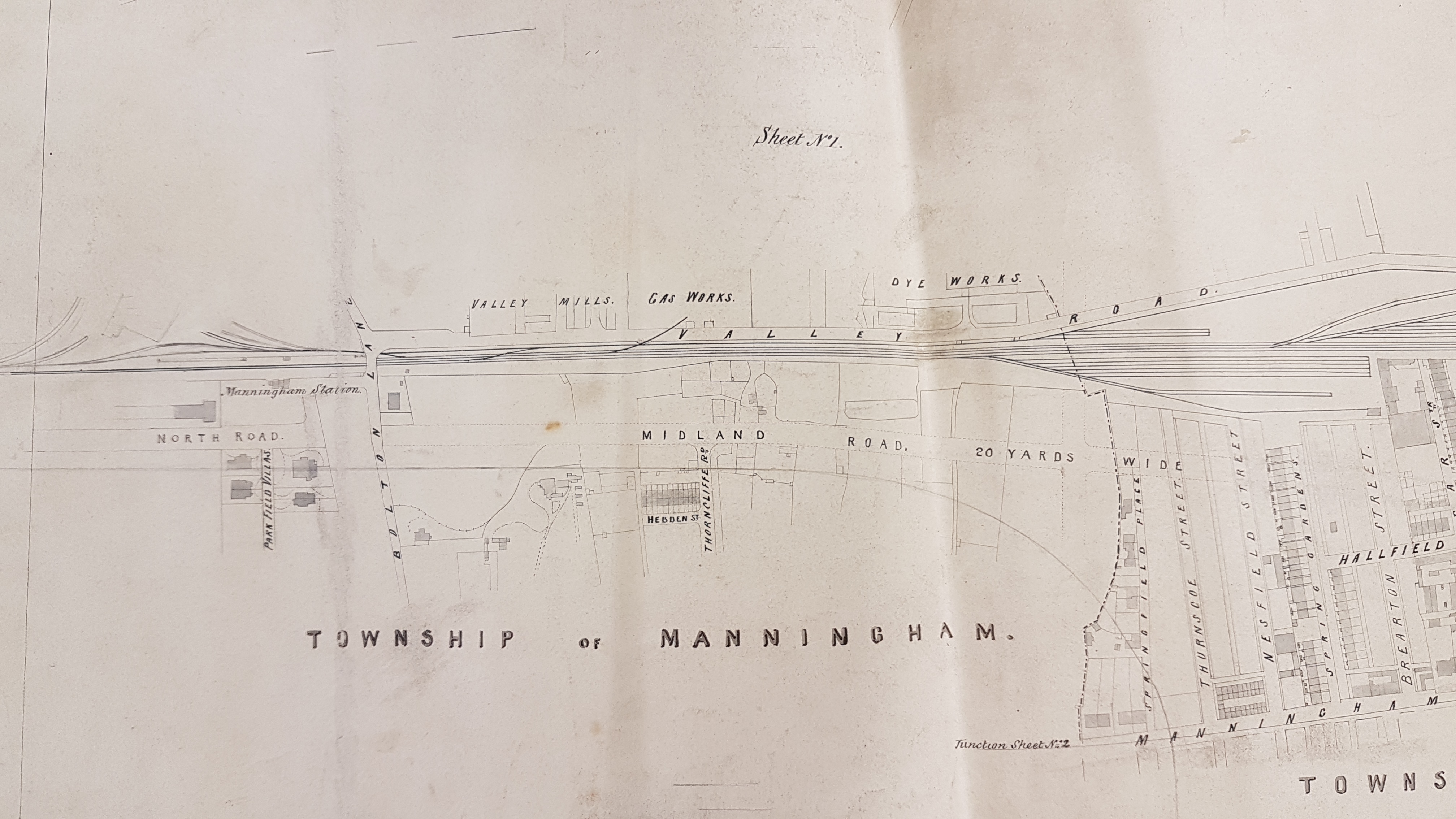
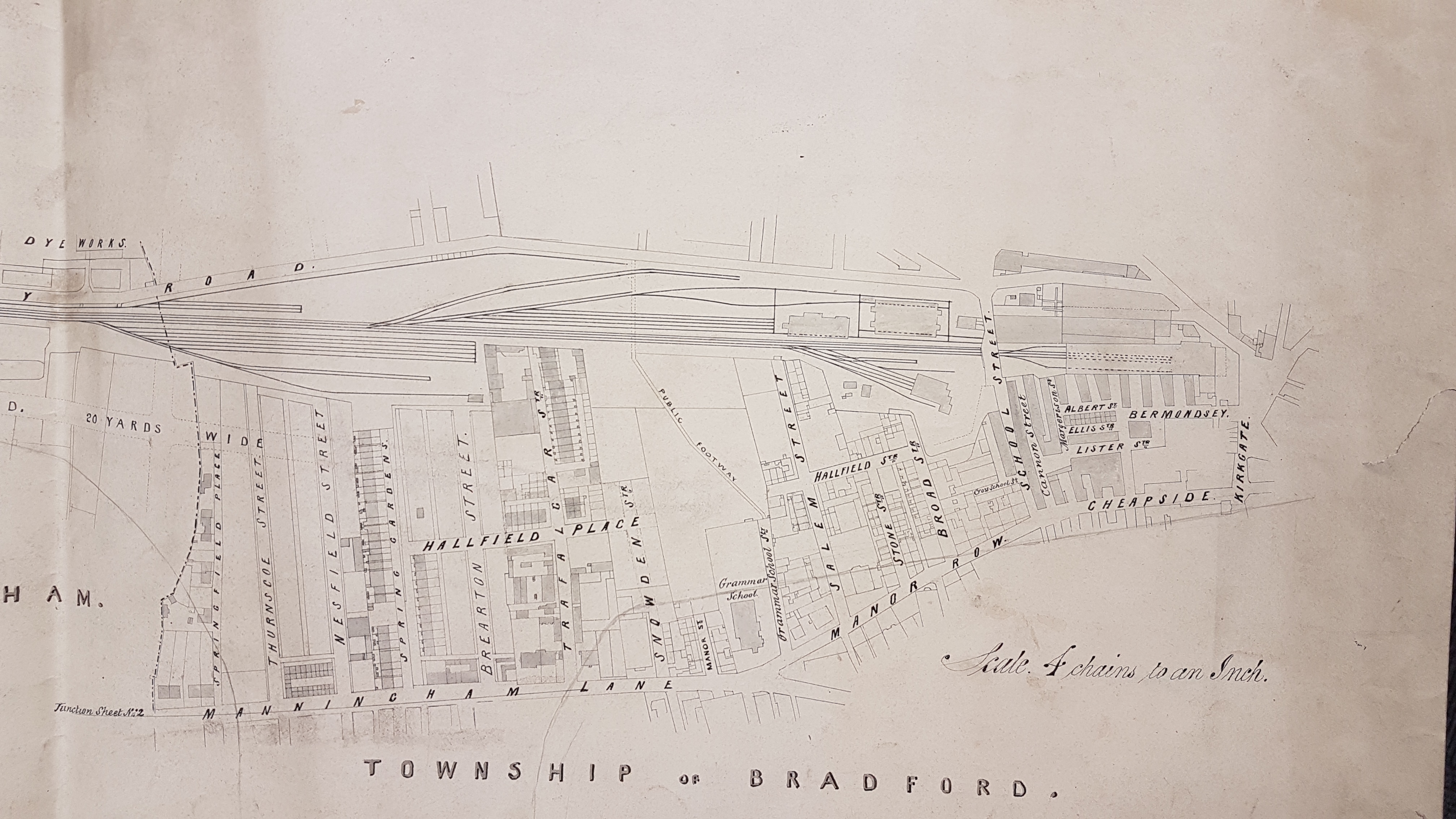
I have shown this plan in two sections. It is not dated or titled although it is marked ‘Sheet no 1’. It may well have been one of a series of such maps. We can be sure that at least one more existed since at the ‘end’ of Manningham Lane is printed ‘junction sheet No.2’. The plan seems to have been a working copy: there are corner pin perforations and several additional pencil lines. It may not show on this reproduction but several sections of track, and the shadowy outline of a building have been added in pencil above Manningham Station. This suggests that the railway and its track is the main focus of the surveyor, although the extension of Midland Road and the street plan between Manor Row and Valley Road are shown in considerable detail. The interrupted line close to Springfield Place is a parliamentary boundary.
The railway reached Bradford by this route in 1846. In overall appearance the plan fits between the first (1852) & second (1895) Ordnance Survey maps of the area, and I initially suggested a date of c.1870 on this basis. This is probably too early. Reports of an appalling gale that struck Bradford in December 1873 described how much building work was then being undertaken between Manningham Lane and Midland Road, this being adjacent to our area of interest. In the Bradford Observer January 1874 stones are reported to be conveyed to Midland Road damaging the existing roadways. An extension of North Road – Midland Road in the direction of Shipley was being discussed publicly the same year and the railway company was reported to be constructing it the following year. The main distinction between this plan and the appearances in the OS map of 1890 is the demolition of the streets north-east of Cheapside and the construction, on the site provided, of the new Midland Station and the Midland Hotel. The hotel construction started in 1885.
If you imagine the line of Cheapside projected straight onwards, after the point at which in reality it bends to form Manor Row, then everything north-east has disappeared by 1895 with the space being used to accommodate railway track. Hallfield Street has gone completely and those roads which once joined it, such as Broad St, Stone St and Salem St have been truncated. The same situation applies to Hallfield Place and the roads joining it. By now you should be able to see where Midland Road is being created. The dotted lines representing it stop at Nestfield Street on the plan although, by 1895, Midland Road had reached Trafalgar Street.
As we follow the course of Midland Road everything between it and Valley Road (east) was to be given over to track. West of Midland Road there was some alteration, such as the construction of the football ground. In general villa development has proceeded apace. The short terrace of Hebden Street has gone and everything between its position and Bolton Lane is replaced by Clifton Villas and similar constructions. Manningham Station remained in the position indicated in the plan. I believe that it was finally closed in 1965.
