3.041 BAR c1860 PLA
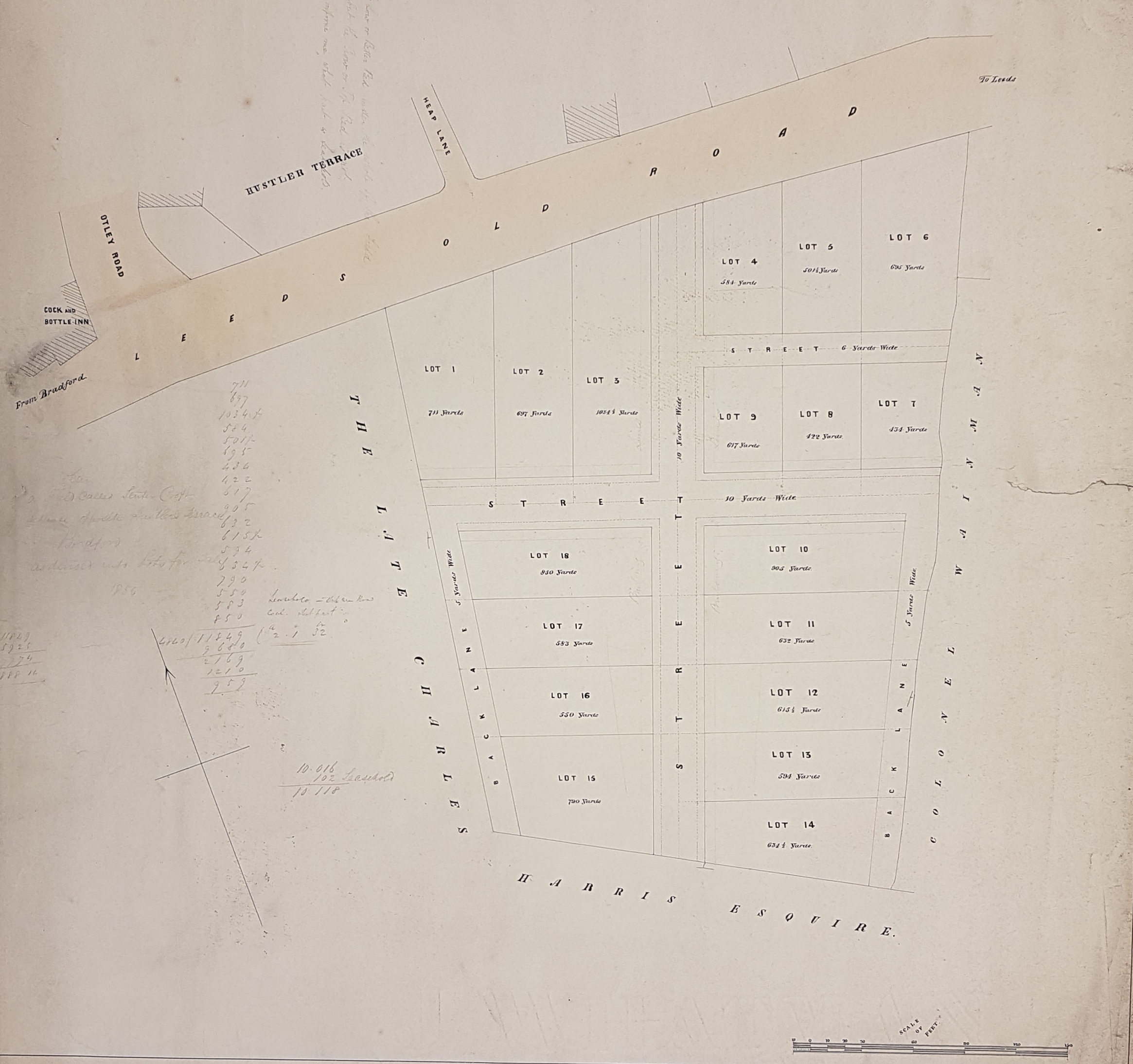
Sale plan: Land south of Barkerend Road, Bradford
Paper Scale: 30 ft per inch Size: 65* 57cm Condition: fair
This plan is not dated nor identified but it is annotated on the reverse ‘plan of Hustlers Field, Leeds Old Road’. It can be placed exactly since Otley Rd, Heap Lane and the Cock & Bottle are named and survive to the present day. We are dealing with a probable sale of building plots on land that was once attached to the site of the Bradford Union Workhouse, south of Barkerend Road.

There are many pencil annotations: what we have was evidently a working plan. One refers to the coal seams and states ‘all the Low or Better Bed under the whole of the field is got but the Crow or Top Bed is not. Cannot inform me what part is leasehold‘. In conventional naming it is the Black Bed seam which is above the Better Bed but, in the past, the naming of seams was often inconsistent. The ground was plausibly mined by the Bunkers Hill Colliery immediately to the east: this is generally associated with the names Rawson, Clayton & Cousen.
By map comparison we are looking at a date after 1850 yet earlier than the 1871 town plan. My preliminary suggestion was c.1860. In the first OS map (1852) Bunkers Hill is described as ‘Wainman’s Pit’ and on our plan the land is identified as belonging to Colonel Wainman. I really don’t know a great deal about this Colonel Wainman. He doesn’t feature among the Bradford ‘gentry and clergy’ in the 1828 or 1834 directories. His name has cropped up as a neighbour of John Wilmer Field in Heaton, and as an owner of Shipley Low Hall and other estate in Shipley. I think he was probably Richard Bradley Wainman (1783-1842) of Carr Head, Cowling near Kildwick but if so I have no idea on what basis he was awarded a colonelcy.
The ‘late Charles Harris’ is also mentioned as a landowner; I assume this was the well-known banker of that name. In 1803 he joined his cousin Edmund Peckover in the firm of Peckover, Harris & Co. The new company evolved into the Bradford Old Bank at Bank Street and then, in 1813, Kirkgate. After Peckover’s death Charles’s two brothers, Henry (1812) and Alfred (1824) also became partners at the bank. Charles Harris, at his retirement in 1840, moved to Fulford Grange, York where he died in 1847. The Hustler of Hustler’s Field is presumably the famous John Hustler, a Quaker merchant to whom the city of Bradford owes a great deal. He died in 1790 and his property would have passed to his sons. He certainly had coal mining interests. Heap Lane (and later Heap Street) was plausibly named after Rev. Henry Heap (1789-1839), Vicar of Bradford.
The continued development of the area is clear from 25 inch map which would have been surveyed in the late 1880s. The Cock & Bottle Inn had been built around 1820. Across Otley Road (at the site labelled Hustler Terrace) is a house and large garden whose presence is only hinted at in our plan. Due south of this was by then the Roman Catholic Church which is still present. Heap Street is the central road on our plan and terrace housing had been constructed on either side of it. Further along Leeds Old Road (Barkerend Road) there is further housing fronting the carriageway but behind this, and extending into ‘Colonel Wainman’s land’, is a Bradford Corporation Yard.
The Leeds Mercury 21 January 1899 published some reminiscences of a George Field, given to the The Bradford Historical and Antiquarian Society which still exists today. Mr Field was describing the situation 60 years earlier, rather before the likely date of the plan then. He stressed the importance of Barkerend Road. Henry Heap was noted to be the vicar: upon his death the remaining glebe land in the area was sold. The Garnett’s had just constructed nearby Barkerend Mill, and Charles Harris was living at Eastbrook House. Hustler Terrace had just been built and was respectable for ‘lesser gentry’. The last of the Hustlers themselves had ‘left for York’ in 1841. The Bradford Workhouse had owned three fields which had been sold off in 1857 to help defray the costs of the new construction at Horton Green, which evolved into St Luke’s Hospital. This date is satisfactorily close to my estimate of 1860 and may be the actual transaction recorded in the plan, although Mr Field states that the land was called ‘workhouse fields’ not Hustler’s Field. Otley Road and Heap Lane survive to the present, as does the listed Cock & Bottle building, but you would struggle to find more survivors from this plan.
