3.023 BRA c.1837 PLA BHM 567 B9
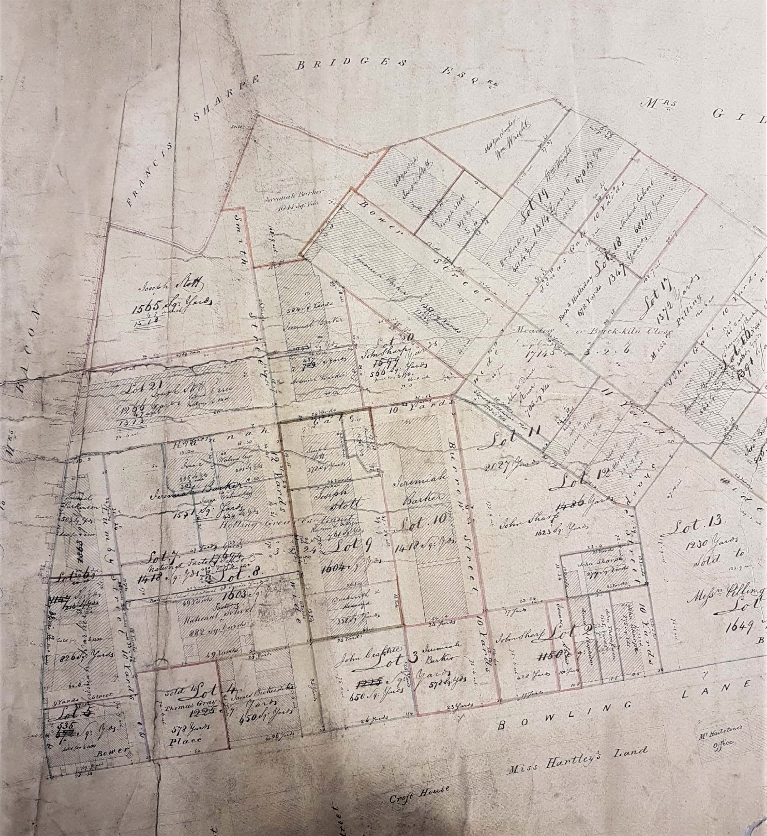
A 22 lots sale plan of land between Bowling Lane & Horton Lane
Paper on linen Scale: unk Size: 110 *76 cm
Condition: poor (old repair and modern reinforcing)
Sometimes I feel I can never get to the end of the information that a single map provides. Here is a good example of one that includes a huge amount of Bradford history. It shows a large parcel of land south of the junction between Horton Lane (now Little Horton Lane) and Bowling Lane (now Manchester Road). Attempts to photograph the whole map result in too much loss of detail so I shall have to illustrate this account with several details. After looking at these you may find the explanatory text helpful.


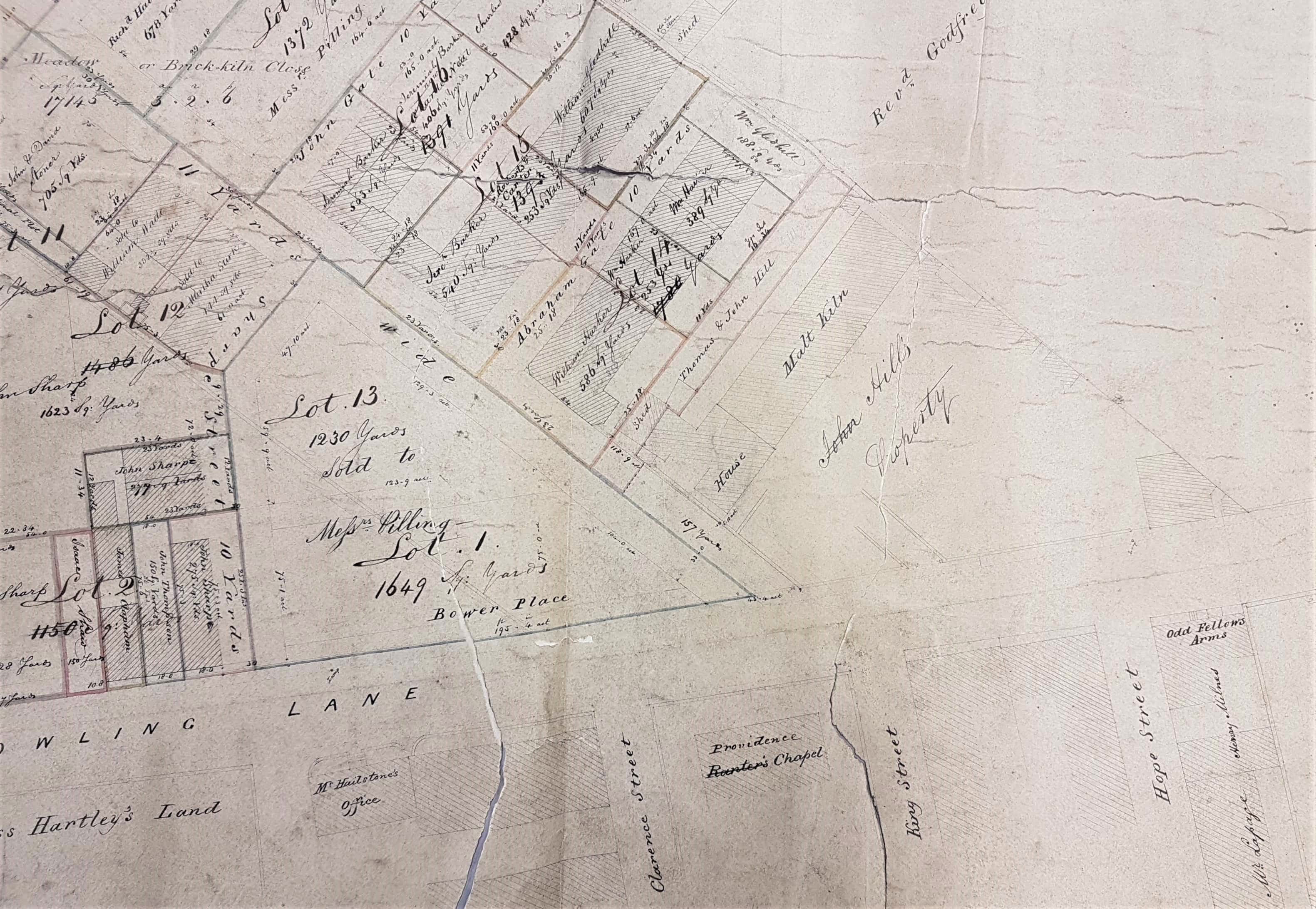


The complete map is untitled but is clearly a sale plan for a fairly large estate divided into 22 lots. It is also undated but must have been drawn up between the years 1836-40 (Queen Victoria ascended to the throne in 1837). To understand the map please note that it is oriented with west at the top. At the time of the sale the estate was effectively a green-field site. The map surveyed in 1834 for the House of Commons commissioners shows the whole area devoid of buildings, except for Mrs Bacon’s house and garden. Within twenty years there was substantial construction, but today everything illustrated is ‘one with Nineveh and Tyre!’
A number of very familiar Bradford land-owning names are included on the map: Rev Godfrey Wright, Mrs Ann Giles, Francis Sharp Bridges of Horton Old Hall (1766-1844), and Mrs Bacon who has a house and garden at the junction of the two principle roads. It is clear from newspaper reports that Mrs Bacon supported many worthy causes: Temperance, the Mechanics Institute, Distressed Scotland, destitution in Canada, and Airedale College. In 1829 she gave two estates, in Fagley and Undercliffe, to support the college. In these reports she is never identified by first name or initial. However William Cudworth, in Rambles Round Horton, describes her as Mary, the daughter of John Balme, the widow of William Bacon. Her residence, unnamed in this map, was known as Spring House. She died in 1853 having been a widow since 1818. After her death there was a substantial sale of her estates fronting Manchester Road and Horton Lane.
Several places of worship are included. Evidently, St John’s Church was soon to be constructed on land belonging to Godfrey Wright adjacent to Mrs Bacon’s property. The church dedication is a common one and the first unambiguous reference to this building in the Bradford Observer is in October 1840. Tenders for its construction were advertised in 1838 and the expense was to be met by a Mr Berthon of the Isle of Wight. The report helpfully lists the other places of worship which, in this age of faith, would be within a ‘stone’s throw’: an independent chapel, a Primitive Methodist chapel, a Unitarian chapel and a new connection Methodist chapel which Mary Bacon herself probably attended. On the other side of the garden is ‘New Chapel’. I believe this must be a portion of land, previously a bowling green (also once the property of Godfrey Wright), acquired in 1836 for the building of Ebenezer chapel. This was rebuilt in 1861 but did not see out the nineteenth century. Higher up Horton Lane is the chapel-yard of Horton Lane chapel. In Bowling Lane is the Ranters’ chapel which has seemingly just changed its name to Providence chapel. I assume this was the home of the ‘Jumping Ranters’ in whose chapel I have read that Chartist meetings were once held. The Ranters seem to have grown out of Primitive Methodism and I assume it was the exuberance of their worship that resulted in the name. Can anyone tell me more?
Also mapped is Rand’s Mill: John & William Rand founded their company in 1803. There is indication of a new malt kiln, and ‘Meadow’ or brick kiln close. Malting barley was necessary for beer brewing. Since 1793 an area of Horton in Manchester Road opposite the Primitive Methodist Church was known as ‘brick kiln field’. I presume that at this early stage itinerant brick-makers took a short-term lease, dug and moulded suitable clay, and then fired the bricks in clamps. Samuel Hailstone (1768-1851) was a famous Bradford solicitor and botanist: his office and residence (Croft House) are drawn. He later moved to Horton Hall. As yet I haven’t been able to identify the vendor of this estate but in 1837 Hailstone offered for sale the land between Croft Street & Bridge Street. This this land was further south and we have a separate map. On the other hand this map is stylistically very similar and of approximately the right date. Could he have been the land-owner?
