3.006 BRA 1868 DIX
Dixon & Hart, surveyors
Paper Scale: 20 yards per inch Size: 70*55 cm Condition: v. poor
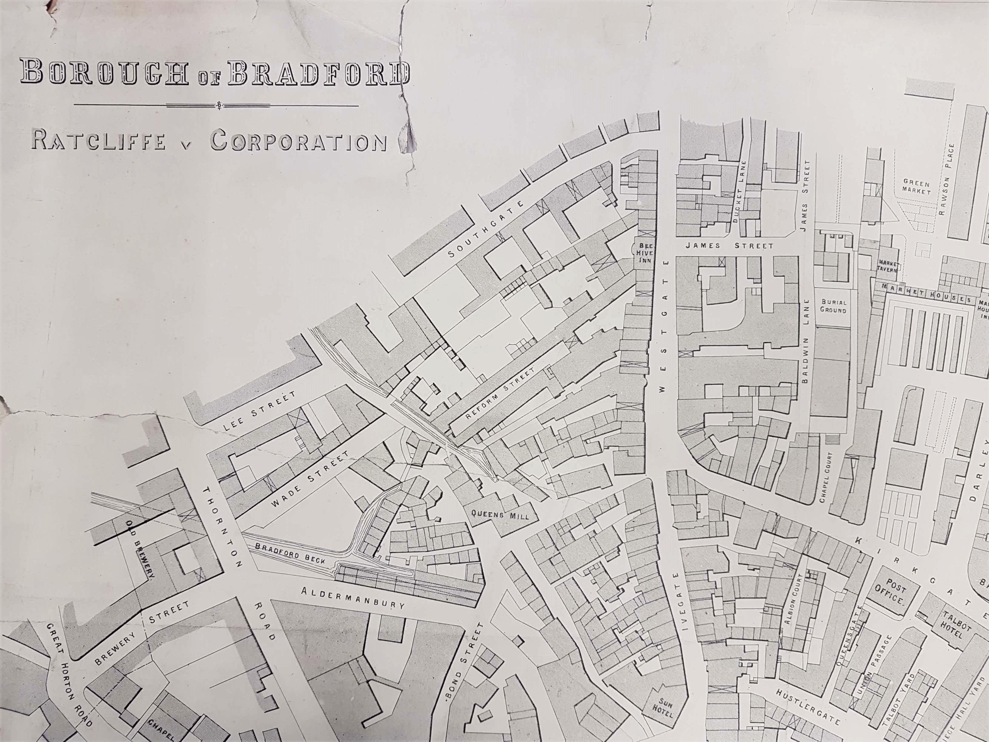
The Local Studies Library has a number of maps with this general configuration in the reserve collection. I assume that the corporation’s planning office had the basic copy which could be amended by over-printing whenever necessary. This map is not dated, nor is any explanation given of who was the ‘Ratcliffe’ mentioned. Evidently he was taking issue with the corporation in some way. The fact that Bradford is a borough places the date of the map as after 1847.

The best chance of obtaining a complete explanation was to identify the case involved. The Bradford Daily Telegraph 19 August 1868 reported the outcome of a compulsory purchase compensation case between John Ratcliffe of Bowling Green and Bradford corporation. This involved property at the corner of Market Street and Bowling Green belonging to him. The sum of £4455 was eventually decided by mutual consent. The property marked 1 on the map would certainly fit this description: possibly there was no dispute over the compensation to be paid for other properties.
A puzzle is that earlier in the year, 9 April 1868, the Bradford Observer had reported the sale of nine pieces of corporation land by J Buckley Sharp. Nine pieces are clearly marked on this map but I can’t make them fit with the reported sale. The account does reveal that John Ratcliffe was a butcher of Bowling Green and that he bought three small portions of land in this sale (named 2,3,5 in the newspaper) fronting New Market Street. It may be that 2 and 5 are plausible, but 3 would be the new Wool Exchange site. In essence the report and the map don’t fit exactly but at least in the census of 1871 there is a John Ratcliffe (52) living with his wife Jane, and six children, at 1 Spring Gardens, off nearby Manningham Lane. He is a butcher with two apprentices, born in Thornton.
The map shows a number of significant buildings including: Midland Station and the Bowling Green Hotel. I initially dated the map as 1868 because the Bradford Wool Exchange (constructed 1867) was included but not Goodwin Street which I believed was established in 1870. The road marked James Street on this map was renamed Godwin Street and the thoroughfare was pushed through to join Duke Street. At the opposite end Godwin Street joined the newly created Sunbridge Road approximately where the Beehive Inn is placed on the map. The name Godwin was given in honour of Alderman Godwin, a recent mayor, and had been decided upon in 1866 (Bradford Observer, November 15 1866). Since Goodwin Street is mentioned in the quoted newspaper land sale reports of 1868 I was unwise to consider its creation could be in a single year.
