3.027 MAN c1850 PLA BHM 817 B11
Land attached to Lady Royd Farm. Squire Lane.
Paper Scale: unk Size: 73*46 cm Condition: fair
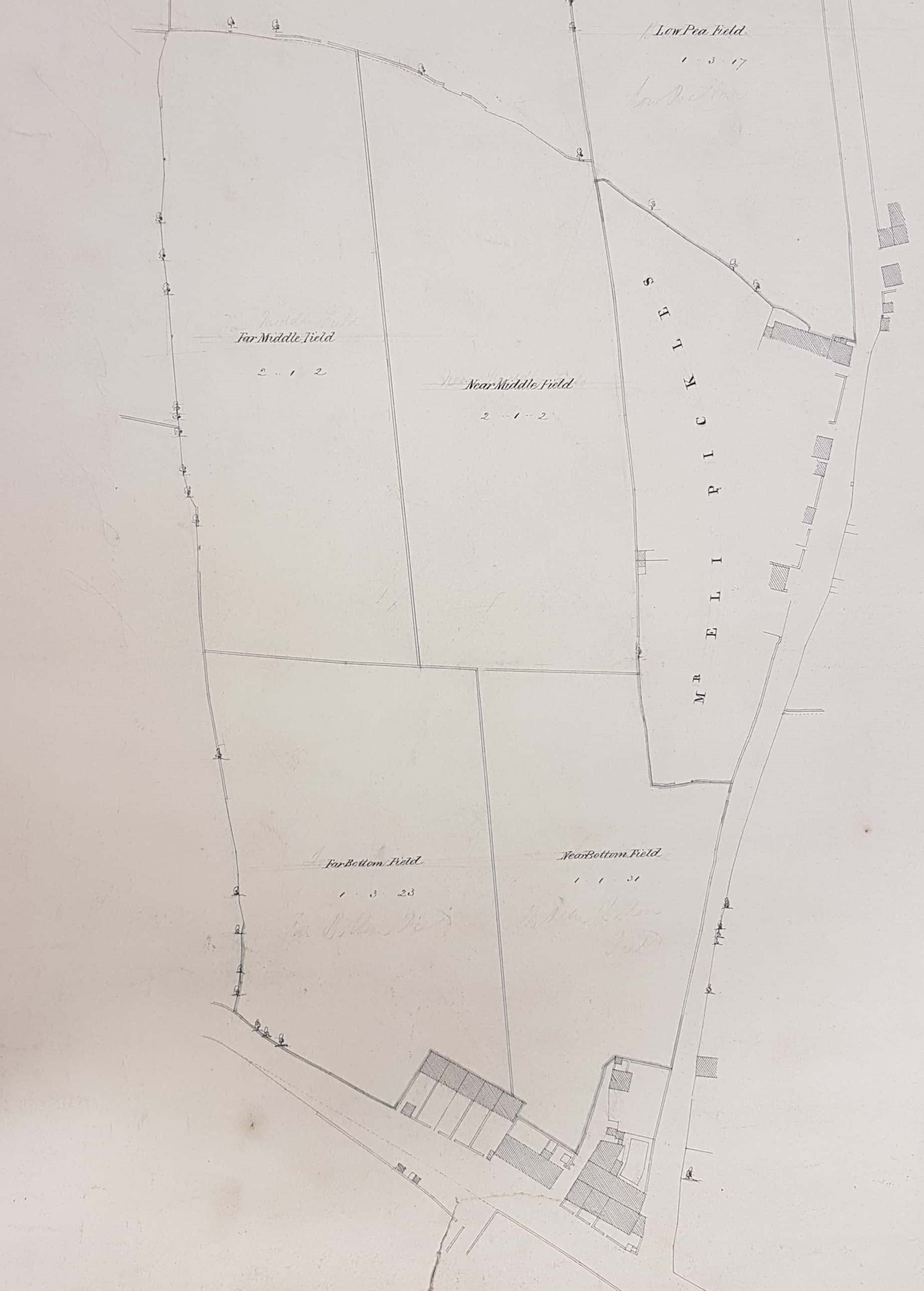
This plan is undated and untitled. Most helpfully on the back it is annotated ‘A148 Lady Royd Farm, Manningham’. To improve visibility I have split it in half and the first image is the bottom and the second the top or the original. As well as Indian ink lines and lettering there are also pencil construction lines which are faint and may not be visible in this image. I would imagine that these were normally erased in the ‘final correct’ version of such a plan. The name Lady Royd or Rode is a very ancient one, and the two sets of dwellings marked on the two images were probably called Upper and Lower Lady Royds.
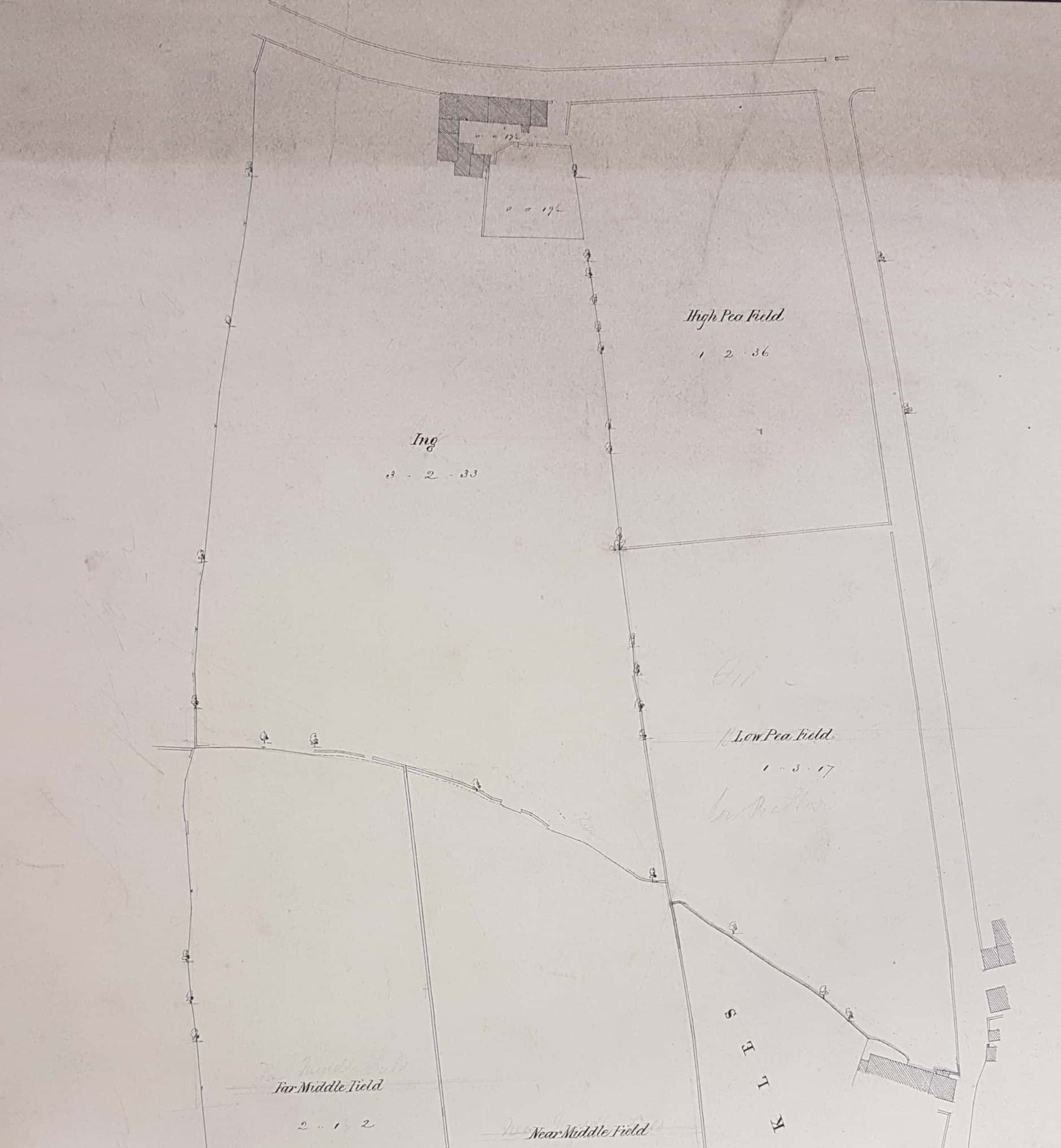
It is easy to check the overall topography with the first Ordnance Survey map of the area (1852). Although there is no direction indicator the plan is aligned conventionally with north at the top. The hamlet at the bottom is Lower Lady Royds. None of the roadways are named here and several names would not be recognisable if they had been. The first OS map indicates that at the bottom of the plan Snake Hill Lane is the road from Bradford and at Lady Royds its name changes to Topham Lane (according to Cudworth named after a local farmer). Today both are accurately, but less charmingly, known as Allerton Road. The road running north is Squire Lane which at the top of the map joins Duckworth Lane. At this point there is a cluster of unnamed buildings which evolved into Lady Royd Hall and Cottage.
On this plan the fields names are given and the boundary pattern is identical to the OS map, which I have used for confirmatory dating purposes. These rectangular field shapes are typical of enclosed land resulting from the various late eighteenth and early nineteenth century Enclosure Acts. The field names themselves are fairly pedestrian: Far Bottom and Near Bottom and so forth. Low and High Pea Fields suggest a crop, and indeed nearby Heaton was famous for its peas, according to its historian Stanley King. The roughly diagonal line running across the centre of the plan, with little formalised trees growing along it, is probably an unnamed watercourse. The plan seems to be quite accurate but the overall rustic impression it gives now is quite misleading. In the real world the bottom right-hand corner was occupied by Four Lane Ends Colliery in the middle of a cluster of ‘old pits’. At the top right corner was a sandstone quarry. In many ways the immediate area looks more rural in the second OS map of 1889 as signs of these extractive industries have vanished. At the time of our plan the only scholars would have been at the Baptist Lady Royds School in the lower hamlet but which is not identified on the plan. This was seemingly a Sunday School erected in 1827. Clearly Mr Eli Pickles is mentioned as a separate landowner. A man of this name was a quarry and delph owner in Bolton and it is his name which unlocks the purpose of the whole plan.
An advertisement in the Bradford Observer indicates that the well-known auctioneer, George Thompson Lister, had arranged to sell the Lady Royd Estate in June 1849 at the Swan Inn, Bradford. The estate was being occupied by Samuel Ackroyd, and ‘Lady Royd’ was his dwelling house, barn, mistal etc. Since these buildings abutted onto Duckworth Lane we are talking about the top of the original plan. This estate and other properties seem to have been the possessions of the late Mr Francis Ackroyd and before him his father Thomas Ackroyd. Eli Pickles receives a mention as an owner of adjacent land. The Baptist School is also mentioned and the land to the west of the estate seems to have been the property of wool-stapler Joshua Lupton. Interestingly prospective purchasers are assured that the land, with its ‘extensive views of Thornton Valley’, would be suitable for villa development but in the event this never occurred. After the time of the Ackroyds, and after 1865, William Cudworth associates Lady Royd Hall with the names of Greenwood Tetley and Henry Illingworth, the brother of textile magnate Alfred Illingworth. The families were also linked with nearby Daisy Bank House, now in the grounds of Bradford Royal Infirmary. They evidently improved the properties and surrounding gardens. Lady Royd Hall was much later (1875) occupied by the Bradford Girls Grammar School.
