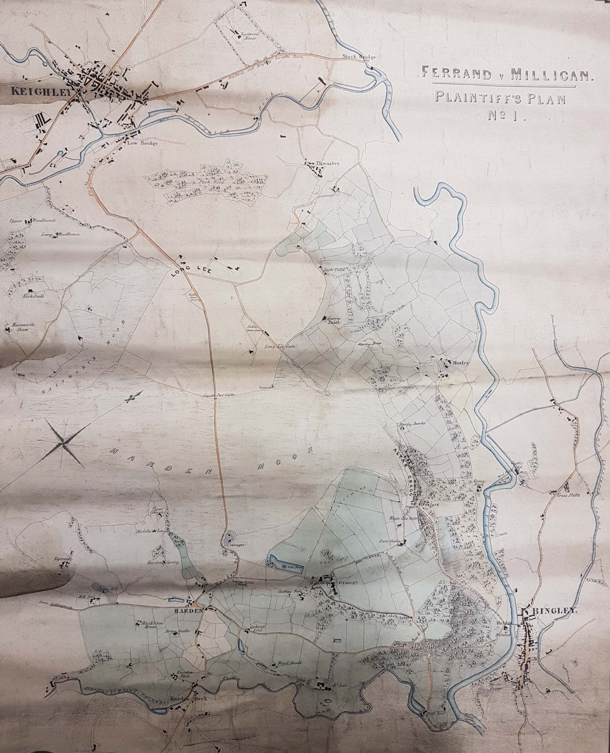
2.15 BIN 1845 FER
Material: linen Scale 12 chains: 1 inch Size: 60 * 45 cm Condition: fair (previously rolled and some water damage)
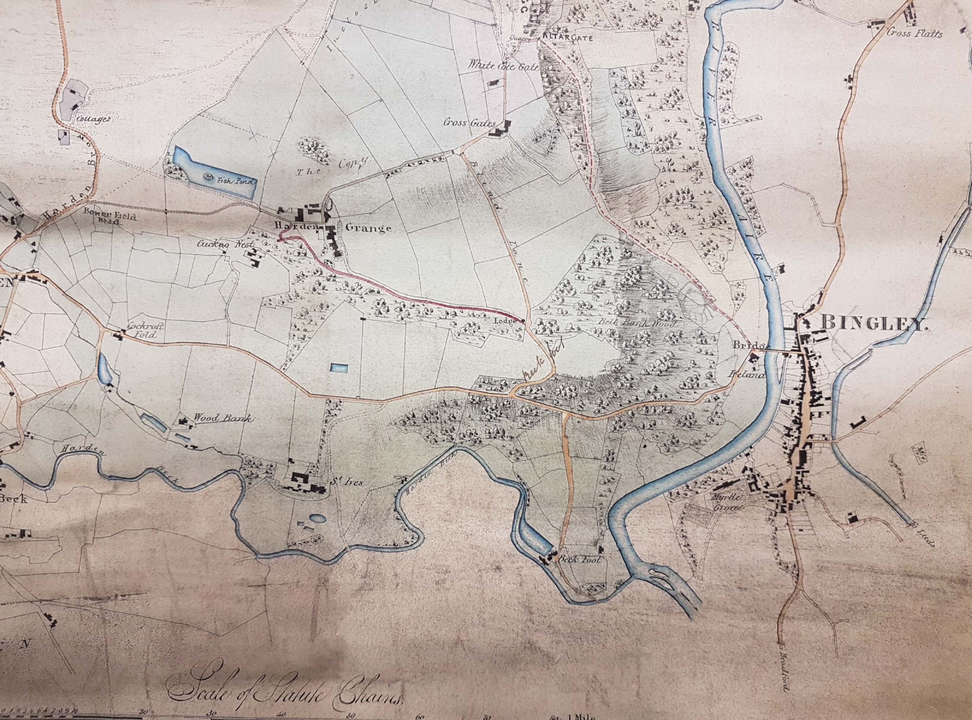
This is a map of the land between Bingley & Keighley surveyed just before the mid-nineteenth century. No railway track is drawn which would indicate a date earlier than 1847. The plan is marked ‘Ferrand v. Milligan plaintiff’s plan No 1’; when I described this map in the Local Studies Library blog I found out a good deal about the legal case which gave rise to it in 1845. The case involved the Harden Grange and St Ives estates which William Busfeild Ferrand ultimately inherited from mother in 1854. I should say at once that subsequent to this map, in 1858, Harden Grange and St Ives exchanged names which is potentially confusing.
William Busfeild Ferrand (1809–1889) was Conservative MP for Knaresborough and lived at Harden Grange (now St Ives). Ferrand v Milligan was a case brought by him to consider the right of the public to use a road to Harden Grange, which I assume is the one that this map identifies in red. The principle defendant is variously named as Mr Milligan or Robert Milligan: who was he? The 1851 census suggests he was Robert Milligan, aged 32, of Harden Mill, worsted spinner. There was also a Walter Milligan, aged 57 and born in Scotland, a worsted & alpaca manufacturer of 38 Myrtle Place, Bingley. Possibly the two men were son and father, certainly Walter Milligan & Son are listed as the proprietors of Harden Mill in many reports until 1861.
An account was first published by The Bradford Observer and Halifax, Huddersfield, and Keighley Reporter, under the title of ‘a village in uproar’, on 18 May 1843. It describes how a certain James Bower walked, with a terrier dog at his heels, along a road through Harden Grange Fold. There he was allegedly seized by Mr Ferrand and his servants while the terrier was ‘worried to death’ by their dogs. Because of local indignation the whole episode was reported to Mr R Milligan, who was then Surveyor of the Highways, and he it was who insisted on the right of the public to use the road concerned. After that things got rapidly out of hand. Robert Milligan proceeded to break down the gate that led on to the road, and to walk ostentatiously down it with a crowd looking on. Mr Ferrand, it was said, hired men to guard what he evidently considered to be his own property. If necessary his rights were to be protected ‘by force’. An emergency meeting of the ratepayers of Harden was summoned and held in Bingley churchyard. Mr Milligan’s conduct was cordially approved by the gathering. Mr Holden of Cullingworth (the future Sir Isaac Holden but then merely the manager of Townend’s Worsted Mill) proposed a motion empowering Milligan ‘to take such steps in law as may be found necessary for defending the right of the public to use the said road’. The newspaper report was very partisan to the inhabitants of Harden who were praised for resisting ‘oppressive encroachments’.
The inevitable legal case was heard at York Spring Assizes in March 1844 before Judge Coltman. It is clear from reports that the action was for trespass against Milligan, and others, in order to establish whether the road which went through the grounds of Harden Grange was indeed a public highway or not. Mr Baines represented the defendants and examined no fewer than 31 witnesses! Mr Knowles for the plaintiff admitted that some local residents and their carts were accustomed to use the road, which ran through a considerable portion of the Harden Grange estate, but he disputed that they had a ‘right’ so to do. He explained that the road had been created in a Major Ferrand’s time (that is c.1797) when he was a tenant. He also confirmed that the plaintiff was not actually the owner of Harden Grange but was ‘entail expectant on his mother’s death’. He further stated his belief that Mr Milligan was animated in his actions by some private feeling, and finally he demanded in excess of 40 shillings damages. The unfortunate jury were then locked away from 7.00 pm until 4.00 am the following morning! With nice judgement they found that there was indeed ‘no carriage road or public foot road’ in existence, but rather than £2 or more the plaintiff (William Busfeild Ferrand that is) was awarded only the derisory sum of one farthing in damages. This was not quite the end of the matter. In another bizarre twist there was an associated criminal case, against Milligan and his servants, which saw him hauled up for ‘riot and assault’. The plaintiff and his barrister seem to have understood that Milligan honestly believed he had a right of way past Harden Grange. Mr Ferrand stated that he wished to live in ‘peace and goodwill with his neighbours’ and as a result offered no evidence against him: consequently the prosecution failed.
A point at issue was under what circumstances the road had been repaired in Major Ferrand’s day and whether repair was at his own expense, or that of the parish. There was also some doubt over whether this evidence was really admissible: a rather a complicated point for a non-lawyer like me to follow. In any event a further action was not allowed by the court. That didn’t restrain the Bradford & Wakefield Observer who reported that ‘in this weather’ it was dangerous to cross the path of William Ferrand on the moors about Harden Grange. If this is all true the map dates from the years immediately before Benjamin Disraeli’s novel Sybil was published in 1845. I am indebted to my fellow library volunteer, Bob Duckett, who tells me that Ferrand and Disraeli were on very friendly terms and that Disraeli had stayed at the house that was to become St Ives. The plot of Sybil involves the increasing discrepancy between rich and poor in industrial towns. The phrase ‘two nations conservatism’ originates with this novel, and is by no means dead now. Was Disraeli, I wonder, witness to any of the events I have mentioned? You can read more of Bob’s conclusions at:
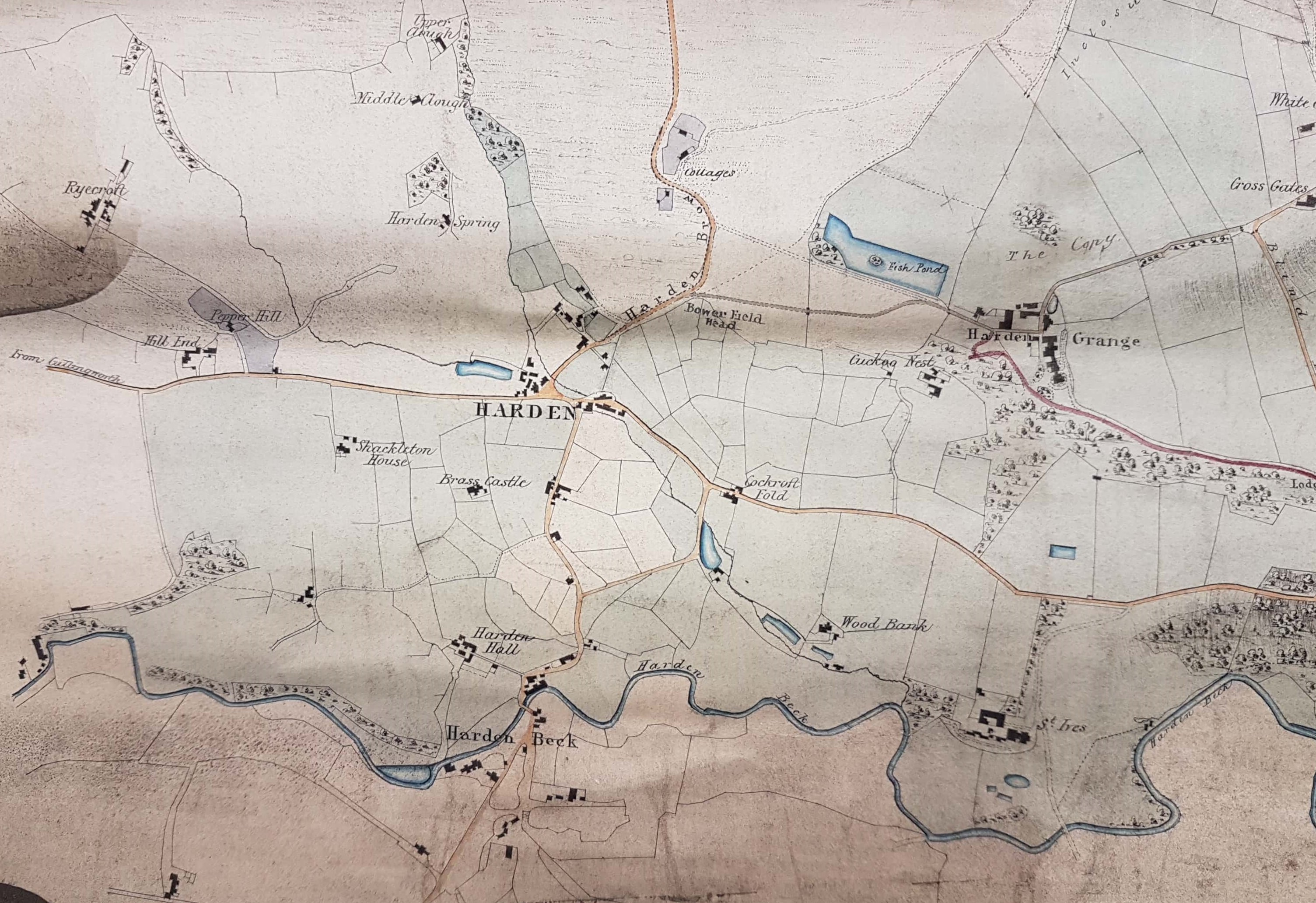
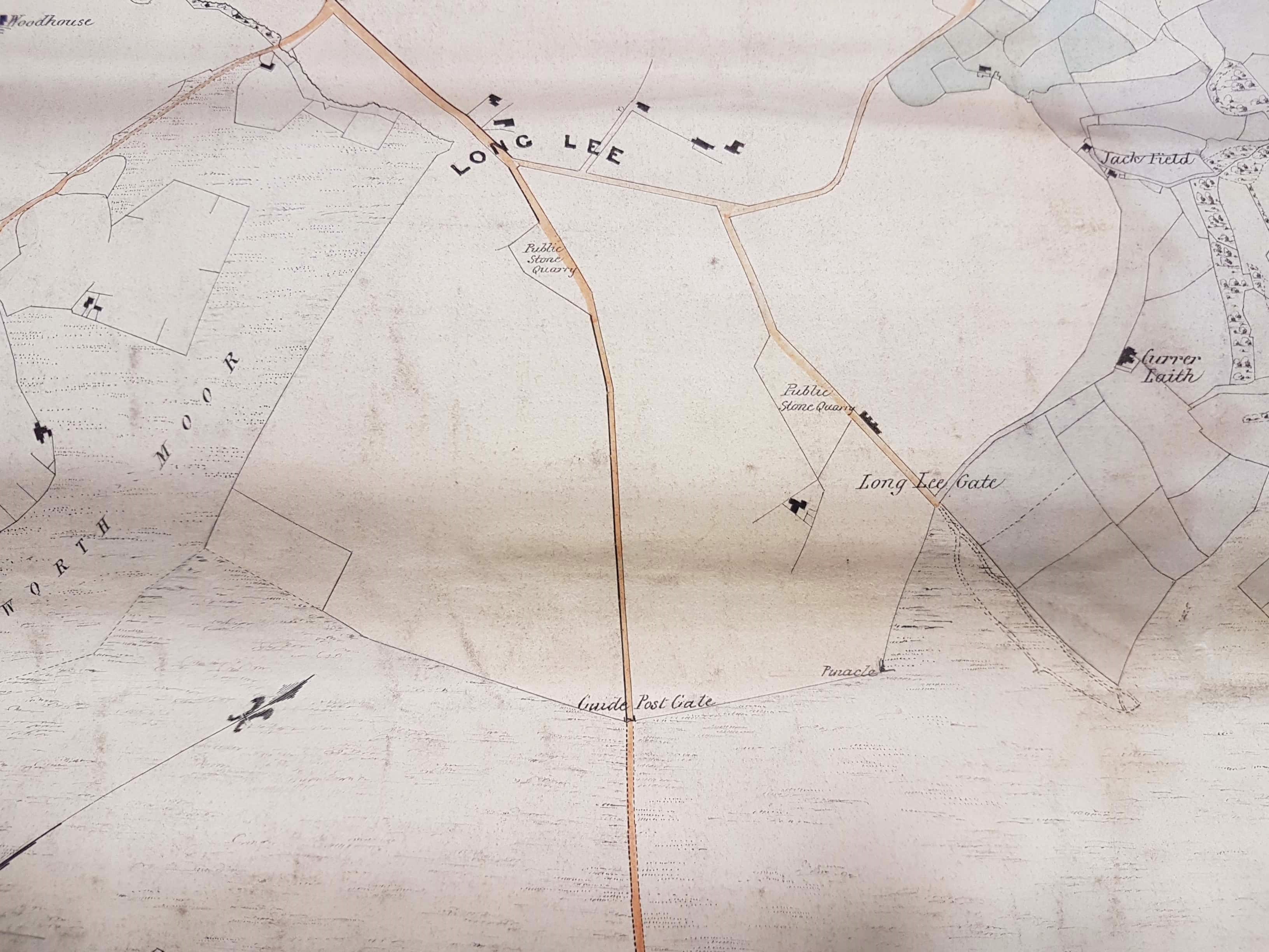
For those of us interested in landscape topography rather than property law the map has other features of interest. Several names seem to have been written onto the original plan for example Altar Cragg and possible Altar Gate and a quarry. A broken red line connects this quarry to Ireland Bridge. I don’t see its relevance to the case but possibly the map was subsequently used by Ferrand’s agent for other purposes. The has been extensive stone quarrying on Harden Moor and many features are still visible to walkers. Near Long Lee are two ‘public stone quarries’. If this description has the obvious meaning of places from which the public could remove stone then it is strange. They seem to be placed on what was then common land but the Lord of the Manor would normally have expected to have mineral rights in such areas. There are several place names of interest. ‘The Copy’ may be a name originating in the old form of land tenure known as copyhold. ‘Clough’ is a deep wooden valley: North Cliffe (Clough) in Shipley is a well-known local example. ‘Spring’ is usually a reference to coppice woodland, springs being coppiced trees from which the poles grow. ‘Laith’ seemingly derives from the Old Norse (ON) meaning a barn and ‘thwaite’ is ON for a village. A ‘flatt’ is a flat area in otherwise hilly ground.

Testing
LikeLike
Great blog! I’d hazard that Harden Spring is more likely to be a spring, there are many issues along the valley sides where water percolates from Harden Moor. These sources provided drinking water to Harden and Bingley. There is still evidence in Deep Cliff wood of 19thC pipework and St Ives estate still uses springs for some of its potable water.
LikeLiked by 1 person