Coal-mining within the city of Bradford was once an extensive and important industry. Bolling Hall is a Grade 1 listed building open to the public as a museum. Along with the cathedral, it must represent the city’s premier historical site. Combining these two interesting and important local history topics produced my favourite plan from the Local Studies Library reserve collection.
Towards the end of the 18th century the owner of the Bolling Hall estate was Captain Sir Charles Wood RN, a painting of whom is still displayed on the main staircase. Captain Wood died of wounds and was succeeded as land-owner and baronet by his son Sir Francis Lindley Wood (1771-1846). Both as estate owner and Lord of the Manor of Bowling Sir Francis controlled access to an immensely profitable asset, the sub-surface minerals. In 1794 Sir Francis gave the nearby Bowling Iron Company (BIC) permission to mine coal and iron ore under his whole estate. After five years he evidently grew tired of being surrounded by mines and spoil tips, however rich they made him, and moved to another of his houses, Hemsworth Hall near Barnsley.
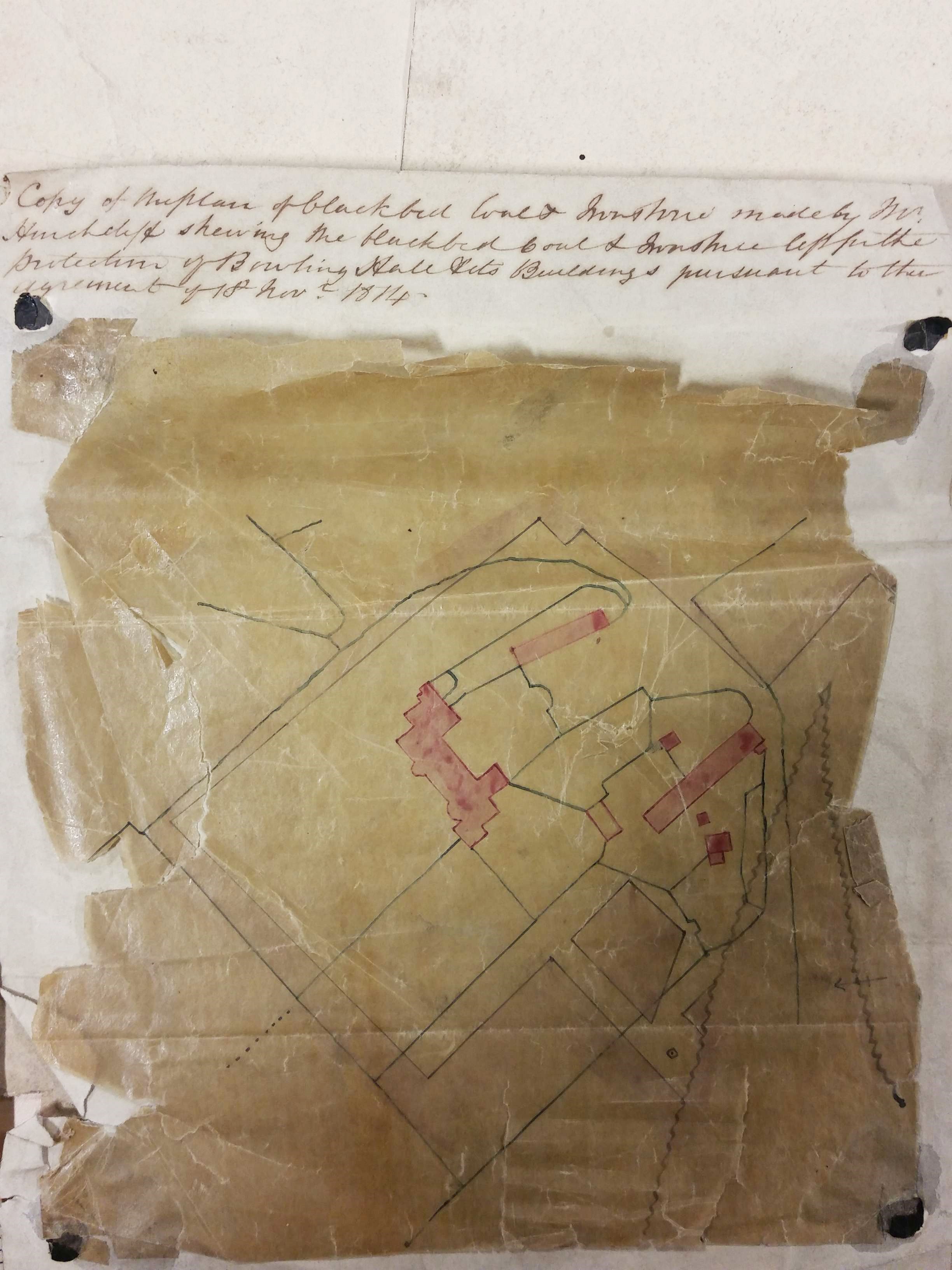
The plan illustrated is 200 year old and is highly relevant to the history of the Bolling Hall estate at a date immediately before it was sold outright to BIC. Victorian hand-writing is not always easy but, with small adjustments to spelling and capitalisation, it reads: ‘Copy of the plan of Black Bed coal and ironstone made by Mr Hinchcliffe showing the Black Bed coal left for the protection of Bolling Hall and its buildings pursuant to the agreement of 18th November 1814‘. Pink blocks represent Bolling Hall and its attendant out-buildings. Many of the black lines are property and field boundaries. This whole central area is slightly paler in colour than the region outside the precinct boundary, which is darker and I assume represents winnable coal. The wavy line, in an inverted V shape to the right, is probably a geological fault. In his description of the area historian William Cudworth reported a Bolling Hall fault which threw minerals ‘down 28 yards to the south’. BIC had been established in 1780 and smelted iron ore found in the roof of the Black Bed coal seam, both of these minerals being mentioned in the plan rubric. A deeper coal seam, the Better Bed, could be turned into a sulphur and phosphorous-free coke which was ideal for iron smelting but this seam is not mentioned on this plan, nor is the shallower Crow Coal seam. The removal of the Black Bed and its ironstone naturally left a gap into which the overburden of rock could collapse, resulting in surface subsidence. The common practice was to leave pillars of minerals unmined to support the gallery roof. Under especially sensitive areas, which included churches, and the mine-owner’s residence, no mining at all took place. To indicate such restraint must be the purpose of this plan.
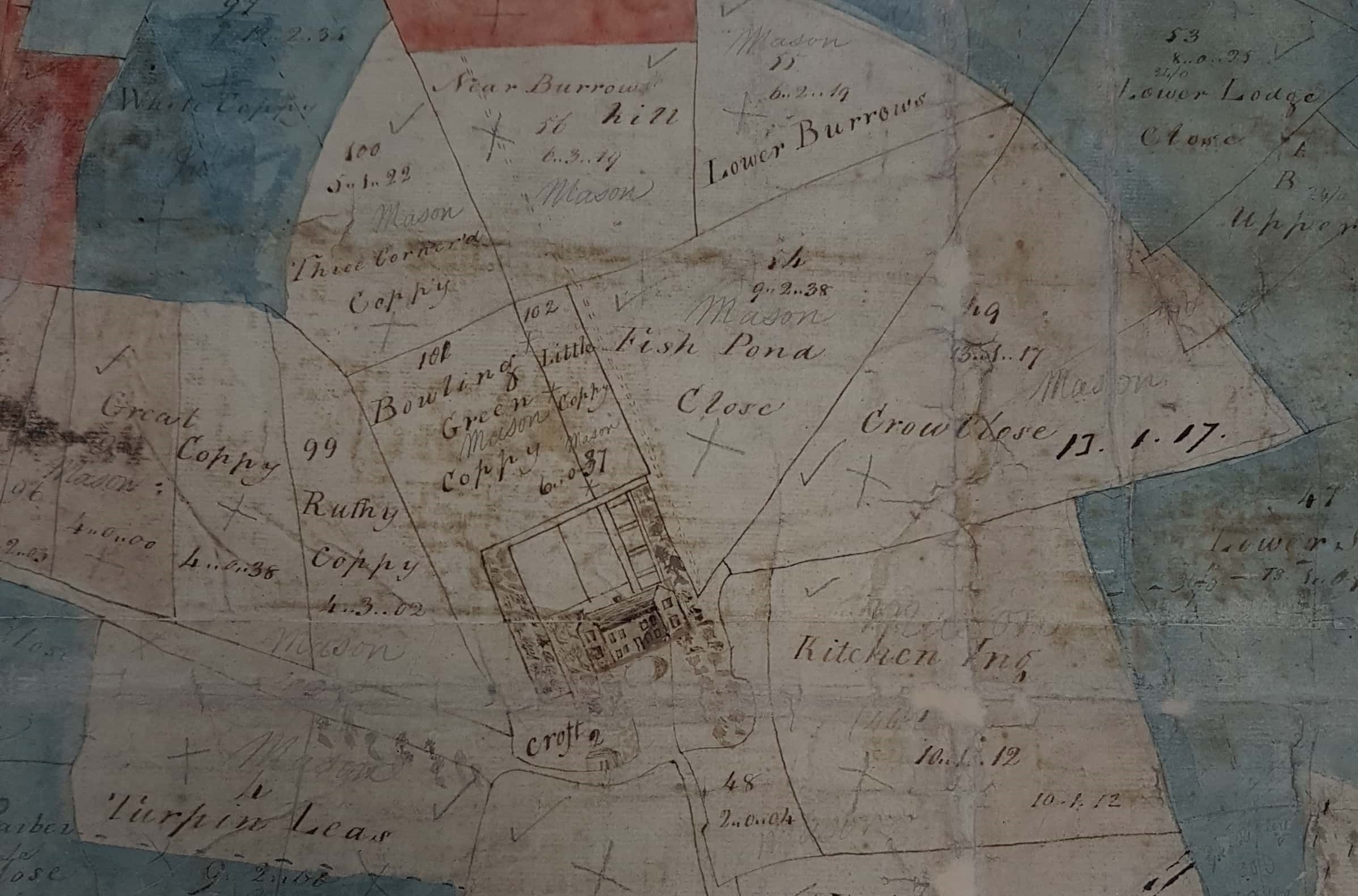
The history of the area can be explored at an even earlier date. The West Yorkshire Archives (Bradford) have a beautiful plan of the entire estate dating from the period of ownership by Sir Francis Lindley Wood (94D85/16/6/1). This map is protected by plastic which makes photography difficult but obtaining images of small sections is possible. The tops of these sections, and indeed the whole map, is south. The map is entitled ‘Plan of Bowling Hall Estate, property of Sir Francis Lindley Wood, Baronet’. When was this title an accurate description? Clearly it was in the period between the death at sea of Capt. Charles Wood RN, in 1782, and the date when Sir Francis sold the entire estate to BIC in 1816. The style of the map is certainly 18th century. Possibly it was originally surveyed when Sir Francis succeeded to the land and title, or when BIC were first given permission to mine. The map has been added to on several occasions, for example an inscription in ink reads: ‘The deed dated 9th August(?) 1806 relating(?) to the Road from the Close No. 47 above the Spring Woods across the Hall Lane to the East side of the Wakefield turnpike road which is to be 20 feet in breadth and the Co(mpany). are to make good and sufficient fences on each side of this (?) road and forever repair the same fences and roads.’ The planned road is indicated on the map as a double broken line; it presumably connected BIC with one of its coal fields. If it survived until modern times it is perhaps represented by Bowling Park Close and New Hey Road or Paley Road. The other end of the new roadway began adjacent to Spring Wood. (Usually ‘spring’ indicates a piece of coppiced woodland rather than referring to surface running water). The second hand-written supplement is dated 1815 (BM12). It is entitled Park House Ing Augt 1815 and gives a series of areas measured in acres, roods and perches. The list includes a ‘Pit Hill’ but I found the writing especially impenetrable.
It is very obvious that some of the fields have been coloured red or blue after the production of the original plan, and the names Mason, Sturges and Paley have been added in pencil, although the surnames and colours do not match exactly. The names are those of the original BIC partners and the division of the estate among these men is likely to have occurred when it passed into the ownership of the company in 1816. The hall and its immediate surrounds carry the name of Mason on the map. At first sight the small picture of Bolling Hall does not look very accurate. You have to remember that the present entrance is via the medieval tower at the rear but the map illustration shows the front elevation, the medieval tower is therefore concealed. The Georgian bay at the left of the building seems to be present and was constructed in 1779-80.
It is interesting to note that a carriage turning circle is illustrated but the range of ancillary buildings (believed to be medieval) down to the right as you face the front entrance is omitted. The arrangements of the garden to the rear are not entirely clear but are evidently complex. The field names recorded: Bowling Green Coppy, Kitchen Ing, Fish pond Close presumably refer to domestic supply arrangements for the hall at an earlier period. ‘Coppy’, which occurs in several of the field names, may refer to the medieval system of copyhold which resembled leasehold. In this system lands belonging to the Lord of the Manor were entrusted to tenants at meetings of the Manor Court.

On the left of the plan is the Wakefield Road turnpike, created in 1752. Adjacent to Wakefield Road, are two unidentified houses (one seemingly quite distinguished). I’m interested in the house which appears to be above (south of) the junction of Wakefield Road and Bowling Back Lane. The image may represent Upper House which Cudworth describes and associates with a man called Joshua Walker, and his son in law John Robinson, towards the end of the 18th century. This section of the map also shows also one, and possibly two, coal fields. The top of the map (south) shows a wide thoroughfare labelled ‘Brierley’ (sic) and ‘turnpike road Leeds to Wibsey’. These roads must be represented by modern Bierley Lane and Rooley Lane. Along the turnpike the map shows a number of dwellings of which the largest is New Hill Hall. Remarkably this building is still extant and is the Grade II listed former clubhouse of the West Bowling Golf Club (Grid Reference: SE 17035 30254). This house was built in the 17th century by the Richardson family of Bierley Hall but, unless there was substantial 18th century redevelopment, the image on our map is not very accurate.

Bolling Hall remained in the ownership of the descendants of the BIC partners for a century. It was given by the last owner, Mr GA Paley, to the City of Bradford in 1912. A good deal of refurbishment has been undertaken since, including the creation of some formal gardens. Architecturally the hall is complex and not, I think it is fair to say, entirely understood even now. The medieval pele tower at the south-west corner contains the modern entrance and is believed to date from c1370. The south-east front Georgian bay was created in 1779-80 and (with its sash windows) contrasts sharply with the 17th century masonry present elsewhere. The hall is a magnificent and fascinating local asset well worth visiting: and I haven’t even started on the famous ghost.
